Yutan, Nebraska | |
---|---|
Coordinates: 41°14′40″N96°23′54″W / 41.24444°N 96.39833°W | |
Country | United States |
State | Nebraska |
County | Saunders |
Township | Union |
Area | |
• Total | 0.57 sq mi (1.49 km2) |
• Land | 0.57 sq mi (1.49 km2) |
• Water | 0.00 sq mi (0.00 km2) |
Elevation | 1,155 ft (352 m) |
Population (2020) | |
• Total | 1,347 |
• Density | 2,346.69/sq mi (906.30/km2) |
Time zone | UTC-6 (Central (CST)) |
• Summer (DST) | UTC-5 (CDT) |
ZIP code | 68073 |
Area code | 402 |
FIPS code | 31-54115 |
GNIS feature ID | 2397396 [2] |
Website | www |
Yutan is a city in Saunders County, Nebraska, United States.
Yutan was originally called Clear Creek, and under the latter name was platted in 1876 when the Omaha and Republican Valley Railroad was extended to that point. It was renamed in 1884 after Ietan, an Otoe Indian chief. [3] [4] [5]
According to the United States Census Bureau, the city has a total area of 0.53 square miles (1.37 km2), all land. [6]
Census | Pop. | Note | %± |
---|---|---|---|
1890 | 168 | — | |
1900 | 263 | 56.5% | |
1910 | 353 | 34.2% | |
1920 | 300 | −15.0% | |
1930 | 313 | 4.3% | |
1940 | 268 | −14.4% | |
1950 | 287 | 7.1% | |
1960 | 335 | 16.7% | |
1970 | 507 | 51.3% | |
1980 | 631 | 24.5% | |
1990 | 626 | −0.8% | |
2000 | 1,216 | 94.2% | |
2010 | 1,174 | −3.5% | |
2020 | 1,347 | 14.7% | |
U.S. Decennial Census [7] |
As of the census [8] of 2010, there were 1,174 people, 432 households, and 324 families living in the city. The population density was 2,215.1 inhabitants per square mile (855.3/km2). There were 449 housing units at an average density of 847.2 per square mile (327.1/km2). The racial makeup of the city was 98.0% White, 0.9% African American, 0.1% Native American, 0.1% Asian, 0.4% from other races, and 0.5% from two or more races. Hispanic or Latino of any race were 1.9% of the population.
There were 432 households, of which 41.7% had children under the age of 18 living with them, 56.5% were married couples living together, 12.0% had a female householder with no husband present, 6.5% had a male householder with no wife present, and 25.0% were non-families. 20.4% of all households were made up of individuals, and 8.4% had someone living alone who was 65 years of age or older. The average household size was 2.72 and the average family size was 3.12.
The median age in the city was 35.4 years. 30.9% of residents were under the age of 18; 7.3% were between the ages of 18 and 24; 25% were from 25 to 44; 26.8% were from 45 to 64; and 10% were 65 years of age or older. The gender makeup of the city was 50.1% male and 49.9% female.
As of the census of 2000, there were 1,216 people, 406 households, and 319 families living in the city. The population density was 2,561.3 inhabitants per square mile (988.9/km2). There were 423 housing units at an average density of 891.0 per square mile (344.0/km2). The racial makeup of the city was 96.71% White, 0.16% African American, 0.82% Native American, 0.49% Asian, 0.25% from other races, and 1.56% from two or more races. Hispanic or Latino of any race were 1.15% of the population.
There were 406 households, out of which 45.1% had children under the age of 18 living with them, 63.1% were married couples living together, 11.8% had a female householder with no husband present, and 21.4% were non-families. 17.7% of all households were made up of individuals, and 7.1% had someone living alone who was 65 years of age or older. The average household size was 3.00 and the average family size was 3.43.
In the city, the population was spread out, with 35.0% under the age of 18, 8.1% from 18 to 24, 31.8% from 25 to 44, 17.8% from 45 to 64, and 7.3% who were 65 years of age or older. The median age was 32 years. For every 100 females, there were 103.0 males. For every 100 females age 18 and over, there were 92.7 males.
As of 2000 the median income for a household in the city was $44,844, and the median income for a family was $52,273. Males had a median income of $36,310 versus $25,850 for females. The per capita income for the city was $16,675. About 1.9% of families and 2.6% of the population were below the poverty line, including 3.5% of those under age 18 and 9.3% of those age 65 or over.
Yutan's schools are administered by Yutan Public Schools. Yutan Elementary School and Yutan High School are located in the city.
Ainsworth is a city and county seat of Brown County, Nebraska, United States. The population was 1,728 at the 2010 census.
Edgar is a city in Clay County, Nebraska, United States. The population was 498 at the 2010 census. It is part of the Hastings, Nebraska Micropolitan Statistical Area.
Mason City is a village in Custer County, Nebraska, United States. The population was 171 at the 2010 census.
Bennington is a city in Douglas County, Nebraska, United States. The population was 2,026 at the 2020 U.S. Census.
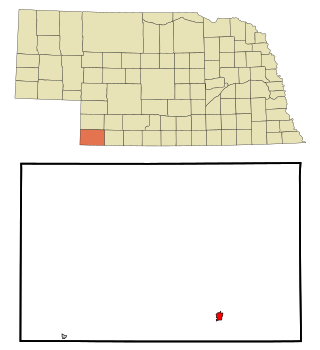
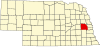
Valley is a city in Douglas County, Nebraska, United States. The population was 3,037 at the 2020 census.
Franklin is a city in Franklin County, Nebraska, United States. The population was 1,000 at the 2010 census. It is the county seat of Franklin County.
Blue Springs is a city in Gage County, Nebraska, United States. The population was 282 at the 2020 census.
Creighton is a city in Knox County, Nebraska, United States. The population was 1,154 at the 2010 census.
Fullerton is a city in, and the county seat of, Nance County, Nebraska, United States. The population was 1,307 as of the 2010 Census.
Osmond is a city in Pierce County, Nebraska, United States. It is part of the Norfolk, Nebraska Micropolitan Statistical Area. The population was 791 at the 2020 census.
Wilber is a city in Saline County, Nebraska, United States. The population was 1,855 at the 2010 census. It is the county seat of Saline County. Wilber is the official "Czech Capital of the USA" and hosts an annual Czech festival in August. Wilber's school is the Wilber-Clatonia High School.
Gretna is a city in Sarpy County, Nebraska, United States. The population was 5,083 at the 2020 census.
Springfield is a city in Sarpy County, Nebraska, United States. The population was 1,501 at the 2020 census.
Leshara is a village in Saunders County, Nebraska, United States. The population was 108 at the 2020 census.
Valparaiso is a village in Saunders County, Nebraska, United States. The population was 595 at the 2020 census.
Rushville is a city in Sheridan County, Nebraska, United States, in the remote Sandhills Region. Its population was 890 at the 2010 census. It is the county seat of Sheridan County.
Fort Calhoun is a city in Washington County, Nebraska, United States. The population was 908 at the 2010 census. The city includes Fort Atkinson, the first fort built west of the Missouri River.
Wayne is a city in Wayne County, Nebraska, United States. The population was 5,660 at the 2010 census. It is the county seat of Wayne County and the home of Wayne State College.
Wakefield is a city in Dixon and Wayne Counties in the State of Nebraska. The population was 1,451 at the 2010 census.
Newman Grove is a city in Madison and Platte Counties in the U.S. state of Nebraska. The population was 721 at the 2010 census.