Taiga, generally referred to in North America as boreal forest or snow forest, is a biome characterized by coniferous forests consisting mostly of pines, spruces, and larches.

Oxisols are a soil order in USDA soil taxonomy, best known for their occurrence in tropical rain forest within 25 degrees north and south of the Equator. In the World Reference Base for Soil Resources (WRB), they belong mainly to the Ferralsols, but some are Plinthosols or Nitisols. Some oxisols have been previously classified as laterite soils.

Alfisols are a soil order in USDA soil taxonomy. Alfisols form in semi-arid to humid areas, typically under a hardwood forest cover. They have a clay-enriched subsoil and relatively high native fertility. "Alf" refers to aluminium (Al) and iron (Fe). Because of their productivity and abundance, the Alfisols represent one of the more important soil orders for food and fiber production. They are widely used both in agriculture and forestry, and are generally easier to keep fertile than other humid-climate soils, though those in Australia and Africa are still very deficient in nitrogen and available phosphorus. Those in monsoonal tropical regions, however, have a tendency to acidify when heavily cultivated, especially when nitrogenous fertilizers are used.

Mollisols are a soil order in USDA soil taxonomy. Mollisols form in semi-arid to semi-humid areas, typically under a grassland cover. They are most commonly found in the mid-latitudes, namely in North America, mostly east of the Rocky Mountains, in South America in Argentina (Pampas) and Brazil, and in Asia in Mongolia and the Russian Steppes. Their parent material is typically base-rich and calcareous and include limestone, loess, or wind-blown sand. The main processes that lead to the formation of grassland Mollisols are melanisation, decomposition, humification and pedoturbation.

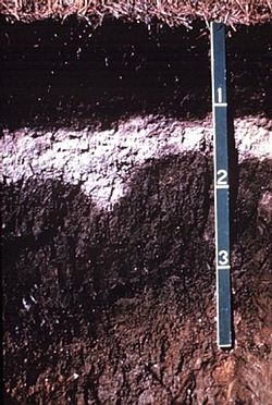
In soil science, podzols are the typical soils of coniferous or boreal forests. They are also the typical soils of eucalypt forests and heathlands in southern Australia. In Western Europe, podzols develop on heathland, which is often a construct of human interference through grazing and burning. In some British moorlands with podzolic soils, cambisols are preserved under Bronze Age barrows.

Gelisols are an order in USDA soil taxonomy. They are soils of very cold climates which are defined as containing permafrost within two meters of the soil surface. The word "Gelisol" comes from the Latin gelare meaning "to freeze", a reference to the process of cryoturbation that occurs from the alternating thawing and freezing characteristic of Gelisols.
A soil horizon is a layer parallel to the soil surface whose physical, chemical and biological characteristics differ from the layers above and beneath. Horizons are defined in many cases by obvious physical features, mainly colour and texture. These may be described both in absolute terms and in terms relative to the surrounding material, i.e. ‘coarser’ or ‘sandier’ than the horizons above and below.
In USDA soil taxonomy, a Psamment is defined as an Entisol which consists basically of unconsolidated sand deposits, often found in shifting sand dunes but also in areas of very coarse-textured parent material subject to millions of years of weathering. This latter case is characteristic of the Guiana Highlands of northern South America. A Psamment has no distinct soil horizons, and must consist entirely of material of loamy sand or coarser in texture. In the World Reference Base for Soil Resources (WRB), Psamments are known as Arenosols.
The World Reference Base for Soil Resources (WRB) is an international soil classification system for naming soils and creating legends for soil maps. The currently valid version is the Update 2015 of the third edition 2014. It is edited by a working group of the International Union of Soil Sciences (IUSS).

In soil classification, an Umbrisol is a soil with a dark topsoil and in which organic matter has accumulated within the mineral surface soil—in most cases with low base saturation—to the extent that it significantly affects the behaviour and utilization of the soil. Umbrisols are the counterpart of comparable soils with a high base saturation.

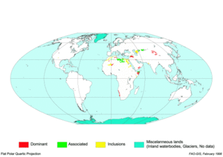
Gypsisols in the World Reference Base for Soil Resources are soils with substantial secondary accumulation of gypsum (CaSO4.2H2O). They are found in the driest parts of the arid climate zone. In the USDA soil taxonomy they are classified as Gypsids (USDA Soil Taxonomy), in the Russian soil classification they are called Desert soils (USSR).

Brown earth is a type of soil. Brown earths are mostly located between 35° and 55° north of the Equator. The largest expanses cover western and central Europe, large areas of western and trans-Uralian Russia, the east coast of America and eastern Asia. Here, areas of brown earth soil types are found particularly in Japan, Korea, China, eastern Australia and New Zealand. Brown earths cover 45% of the land in England and Wales. They are common in lowland areas on permeable parent material. The most common vegetation types are deciduous woodland and grassland. Due to the reasonable natural fertility of brown earths, large tracts of deciduous woodland have been cut down and the land is now used for farming. They are normally located in regions with a humid temperate climate. Rainfall totals are moderate, usually below 76 cm per year, and temperatures range from 4 °C in the winter to 18 °C in the summer. They are well-drained fertile soils with a pH of between 5.0 and 6.5.

A Cambisol in the World Reference Base for Soil Resources (WRB) is a soil with a beginning of soil formation. The horizon differentiation is weak. This is evident from weak, mostly brownish discolouration and/or structure formation in the soil profile.

A Regosol in the World Reference Base for Soil Resources (WRB) is very weakly developed mineral soil in unconsolidated materials. Regosols are extensive in eroding lands, in particular in arid and semi-arid areas and in mountain regions. Internationally, Regosols correlate with soil taxa that are marked by incipient soil formation such as Entisols in the USDA soil taxonomy or Rudosols and possibly some Tenosols in the Australian Soil Classification.

A Planosol in the World Reference Base for Soil Resources is a soil with a light-coloured, coarse-textured, surface horizon that shows signs of periodic water stagnation and abruptly overlies a dense, slowly permeable subsoil with significantly more clay than the surface horizon. In the US Soil Classification of 1938 used the name Planosols, whereas its successor, the USDA soil taxonomy, includes most Planosols in the Great Groups Albaqualfs, Albaquults and Argialbolls.

A Stagnosol in the World Reference Base for Soil Resources (WRB) is soil with strong mottling of the soil profile due to redox processes caused by stagnating surface water.

A fluvisol in the World Reference Base for Soil Resources (WRB) is a genetically young soil in alluvial deposits. Apart from river sediments, they also occur in lacustrine and marine deposits. Fluvisols correlate with fluvents and fluvaquents of the USDA soil taxonomy. The good natural fertility of most fluvisols and their attractive dwelling sites on river levees and higher parts in marine landscapes were recognized in prehistoric times.
Luvisols are a group of soils, comprising one of the 32 Reference Soil Groups in the international system of soil classification, the World Reference Base for Soil Resources (WRB). They are widespread, especially in temperate climates, and are generally fertile. Luvisols are widely used for agriculture.
The Polish Soil Classification is a soil classification system used to describe, classify and organize the knowledge about soils in Poland.
A Retisol is a Reference Soil Group of the World Reference Base for Soil Resources (WRB). Retisols are characterized by clay migration and an additional specific feature: The clay-poorer and lighter coloured eluvial horizon intercalates netlike into the clay-richer more intensely coloured illuvial horizon. The illuvial horizon is the diagnostic argic horizon, and the intercalation is called retic properties.


