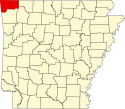
Apple Spur, Arkansas

Last updated

Apple Spur
USA Arkansas location map.svg
Red pog.svg
Apple Spur
Apple Spur's position in Arkansas
Usa edcp location map.svg
Red pog.svg
Apple Spur
Apple Spur (the United States)
Coordinates: 36°21′22″N94°09′42″W / 36.35611°N 94.16167°W / 36.35611; -94.16167
Country Flag of the United States (23px).png  United States
State Flag of Arkansas.svg  Arkansas
County Washington
Township 2
Elevation
[1]
400 m (1,300 ft)
Time zone UTC-6 (Central (CST))
  Summer (DST) UTC-5 (CDT)
ZIP code
72745
Area code 479
GNIS feature ID75365 [1]

Apple Spur is an unincorporated community in Township 2, Benton County, Arkansas, United States. [1]

Related Research Articles

<span class="mw-page-title-main">Interstate 530</span> Highway in Arkansas

Interstate 530 (I-530) in Arkansas is a spur route of the Interstate highway system, traveling 46.65 miles (75.08 km) from Pine Bluff north-northwest to Little Rock at an interchange of I-30/I-440/U.S. Highway 65 (US 65)/US 67/US 167. The highway also travels through the cities of Redfield and White Hall. In the future, I-530 will be extended to I-69 west of Monticello. A short section near the future I-69 alignment has been signed as Highway 530 (AR 530).

<span class="mw-page-title-main">Interstate 540 (Arkansas)</span> Highway in Arkansas

Interstate 540 (I-540) is a freeway spur route of I-40 in the US state of Arkansas in Fort Smith. The total length is 14.7 miles (23.7 km). At first, I-540 was a short spur connecting Fort Smith and Van Buren to I-40 as one of the original five Arkansas Interstates. The route ran 14.7 miles (23.7 km) to U.S. Highway 271 (US 271) near the Oklahoma state line. The growing Northwest Arkansas area and the University of Arkansas needed an Interstate connection to Little Rock, and through traffic north to Kansas City had also outgrown the winding US 71 north from I-40. The route was extended north to Mountainburg in the late 1990s on an all-new alignment with the route being completed to Bella Vista in January 1999. However, the segment north of I-40 became a part of I-49 in 2014.

<span class="mw-page-title-main">Arkansas Highway 367</span> State highway in Arkansas, United States

Arkansas Highway 367 is a designation for two north–south state highways in Arkansas. A southern route of 15.03 miles (24.19 km) travels north from U.S. Route 167 (US 167) in East End north to US 70/AR 365 in Little Rock. A northern route of 81.52 miles (131.19 km) begins in Cabot at US 67/AR 5/AR 321 and travels northeast to US 412B in Walnut Ridge.

<span class="mw-page-title-main">Arkansas Highway 321</span> State highway in Arkansas, United States

Highway 321 is a designation for two north–south state highways in central Arkansas. One route of 11.20 miles (18.02 km) runs from Highway 5/Highway 367 in Cabot north to Highway 38 east of Austin. A second route of 3.79 miles (6.10 km) begins at AR 31 north of Beebe and runs north to Highway 267.

<span class="mw-page-title-main">Arkansas Highway 127</span> State highway in Arkansas

Highway 127 is a designation for four state highways in Northwest Arkansas. One route of 4.13 miles (6.65 km) begins at Madison County Road 3345 (CR 3345) and runs northwest to Highway 23 at Aurora. A second route of 4.86 miles (7.82 km) begins at US Highway 412 (US 412) at Old Alabam and runs north to Highway 23 at Forum. A third route of 8.58 miles (13.81 km) begins at Highway 12 and runs north to Highway 12 near Clifty. A fourth route of 5.82 miles (9.37 km) begins at Lost Bridge Village and runs north to US Highway 62 in Garfield. Highway 127 Spur is a spur route of 0.25 miles (0.40 km) near the southern terminus of the Lost Bridge Village route that provides access to Lost Bridge Marina. All routes are maintained by the Arkansas State Highway and Transportation Department (AHTD).

<span class="mw-page-title-main">Arkansas Highway 8</span> State highway in Arkansas, United States

Highway 8 is an east–west state highway in Lower Arkansas. The route of 229.83 miles (369.88 km) runs from Oklahoma State Highway 63 (SH-63) at the Oklahoma state line east across the state to US Route 65 (US 65) south of Eudora.

<span class="mw-page-title-main">Arkansas Highway 9</span> American state highway

Highway 9 is a designation for two north–south state highways in Arkansas. A southern segment of 51.44 miles (82.78 km) begins at U.S. Route 79 at Eagle Mills and heads north to U.S. Route 67 in Malvern before terminating. The northern segment of 174.17 miles (280.30 km) runs from AR 5 to U.S. Route 63 in Mammoth Spring. The route was created during the 1926 Arkansas state highway numbering, and has seen only minor extensions and realignments since. Pieces of both routes are designated as Arkansas Heritage Trails for use during the Civil War and the Trail of Tears.

<span class="mw-page-title-main">Arkansas Highway 69</span> State highway in Arkansas, United States

Highway 69 is a designation for three north–south state highways in northeast Arkansas. A western route of 57.64 miles (92.76 km) runs south from Highway 9 at Melbourne to Highway 14/Highway 367 in Newport. A second route of 15.31 miles (24.64 km) begins at Highway 163 and runs north through Trumann to Highway 158 at Lunsford. A third route begins at U.S. Route 49/Highway 1 (US 49/AR 1) at the city limits of Paragould and runs north to terminate at US 412B in the city.

<span class="mw-page-title-main">Arkansas Black</span> Apple cultivar

The Arkansas Black is an apple cultivar that originated in the mid-19th Century in Benton County, Arkansas. It is not the same as the cultivar 'Arkansas' or 'Arkansas Black Twig'.

<span class="mw-page-title-main">Business routes of Arkansas Highway 1</span> Highway system

Six business routes of Arkansas Highway 1 currently exist, with one spur route. Each of the routes is a former alignment of Arkansas Highway 1, which is common practice.

<span class="mw-page-title-main">Auxiliary routes of Arkansas Highway 7</span> State highway in Arkansas, United States

Six auxiliary routes of Arkansas Highway 7 currently exist. Four are spur routes, one is a business route, and one is a truck route. They are listed below in south-to-north order.

<span class="mw-page-title-main">Auxiliary routes of Arkansas Highway 25</span> State highway in Arkansas, United States

Three auxiliary routes of Arkansas Highway 25 currently exist. Two are spur routes, with one serving as a business route.

Three auxiliary routes of Arkansas Highway 18 exist in Northeast Arkansas, with one former alignment.

<span class="mw-page-title-main">Arkansas Highway 20</span> State highway in Arkansas, United States

Arkansas Highway 20 is an east–west state highway in Phillips County, Arkansas. The route of 31.76 miles (51.11 km) runs from Lambrook northeast to US 49 in Helena-West Helena. Segments of the route make up the western routing of the Great River Road.

<span class="mw-page-title-main">Arkansas Highway 39</span> State highway in Arkansas, United States

Highway 39 is a designation for two state highways in southeast Arkansas. The western segment of 9.98 miles (16.06 km) runs from US Route 49 (US 49) at Blackton to US 49/Highway 241. Another segment of 8.89 miles (14.31 km) runs north from Highway 1 and Highway 316 near Turner to US 49 in rural Phillips County.

Eight auxiliary routes of Arkansas Highway 69 currently exist. Four are spur routes, with four serving as business routes.

<span class="mw-page-title-main">Goldspur</span> Apple cultivar

Goldspur or Golden Spur is a Golden Delicious-like apple cultivar which is spur bearing. It is a very compact tree, dwarf and column growing.

<span class="mw-page-title-main">Wijcik McIntosh</span> Apple cultivar

Wijcik McIntosh is a mutation of the McIntosh apple that has a columnar growing habit, meaning that it grows straight and upright, and is spur-bearing, without any major branching. This property is very much appreciated for use as an ornamental plant for itself, and also in the breeding of other apple cultivars, to make them columnar as well.

References