
Ernakulam, IPA: [erɐɳɐːguɭɐm]; IAST: Eṟaṇākuḷaṁ, in Malayalam: എറണാകുളം) is a district of Kerala, India, that takes its name from the eponymous city division in Kochi. It is situated in the central part of the state, spans an area of about 3,000 square kilometres (1,200 sq mi), and is home to over 9% of Kerala's population. Its headquarters are located at Kakkanad. The district includes Kochi, also known as the commercial capital of Kerala, which is famous for its ancient Hindu temples, churches, synagogues and mosques. The district includes the largest metropolitan region of the state: Greater Cochin. Ernakulam is the district that yields the most revenue and the largest number of industries in the state. Ernakulam is the third most populous district in Kerala, after Malappuram and Thiruvananthapuram. The district also hosts the highest number of international and domestic tourists in Kerala state.

Aluva is a region in the city of Kochi in Kerala, India. It is also a part of the Kochi metropolitan area and is situated around 15 km (9.3 mi) from the city center on the banks of Periyar River. A major transportation hub, with easy access to all major forms of transportation, Aluva acts as a corridor which links the highland districts to the rest of the state. Cochin International Airport at Nedumbassery is 11.7 km from Aluva. Aluva is accessible through rail, air, metro along with major highways and roadlines. Aluva KSRTC bus station is an important transport hub in Kerala and one of the busiest stations in central part of the state.

Mattanur, also spelled Mattannur, is a town, municipality, and an aerotropolis in Kannur district, Kerala, India. Mattanur is about 27 km east of Kannur and Thalassery, two major towns of the district.
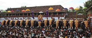
Sree Poornathrayesa temple is a Hindu temple situated in Tripunithura, Kochi, the capital of the former Kingdom of Cochin, Kerala, India. The temple is considered among the greatest temples in Kerala and was the first among eight royal temples of the erstwhile Kochi Kingdom. The deity was also considered the national deity of Cochin and protector guardian of Tripunithura. The deity in this temple is Lord Vishnu, who is in the form of Santhanagopala Murthy. Lord Poornathrayeesa is known for his love of elephants. Hence more than 40 elephants participate in his Vrishchikotsavam. And most of the elephants are sent for the utsavam (festival) without a money return expected by the elephant owners as Poornathrayeesa is considered to be an elephant lover.

Thrissur is a district of Kerala situated in the central part of that state. Spanning an area of about 3,032 km2 (1,171 sq mi), Thrissur district is home to over 9% of Kerala's population.
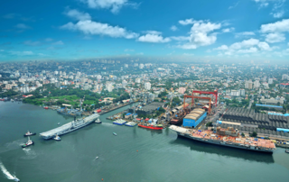
Ernakulam, is the central portion of the city of Kochi in Kerala, India and has lent its name to the Ernakulam district. Many major establishments, including the Kerala High Court, the office of the Kochi Municipal Corporation and the Cochin Shipyard are situated here. Ernakulam, which is where a huge part of the commercial activity in Kochi city happen, is known as the commercial capital of Kerala. The Ernakulam Junction is a major railway station of the Indian Railways, and the busiest railway station in Kochi city, the 2nd busiest in Thiruvananthapuram railway division and the 5th busiest in Southern Railways. Initially, Ernakulam was the headquarters of the Ernakulam District but was later shifted to Kakkanad, an eastern region in Kochi. Ernakulam was once the capital of the Kingdom of Cochin. It is located 220 kilometres (137 mi) north - west of the state capital Thiruvananthapuram. The city has served as an incubator for many Malayali entrepreneurs and is a major financial and commercial hub of Kerala. The Kochi Metro's first phase runs through Ernakulam region as well. The second phase aims to connect the CBD with the IT hub of Kakkanad.

Piravom is a Municipality in Ernakulam district and a suburb of Kochi in the Indian state of Kerala. It is located with in 31 km southeast of Kochi city center, at the boundary of the Ernakulam and Kottayam districts. Piravom is famous for its Hindu temples and Christian churches. Piravom has a river-front, verdant hills, and paddy fields.

Garudan Thookkam is a ritual art form performed in certain Kali temples in some Central Kerala districts in south India. The people who dress up as Garuda perform the dance. After the dance performance, the hang-designate dangle from a shaft hooking the skin on his back. In some places, the ritual is performed colorfully with Garudas taken in a procession on bullock carts or boats or hand pulled carts. It will be available in Devi temple during the festival of Meena bharani and Pathamudayam in Thiruvanchoor in Kottayam district.
Kondotty is a developing town, municipality, and aerotropolis in the Malappuram district state of Kerala, India which is located near Calicut International Airport, 24 km from Malappuram. It is the headquarters of Kondotty Taluk, which was declared as the seventh taluk in Malappuram district by chief minister Oommen Chandy on 23 December 2013.

Kochi is a city in the Indian state of Kerala. Kochi is located in the district of Ernakulam. Old Kochi loosely refers to a group of islands including Willingdon Island, Fort Kochi, Mattancherry and Mundamveli In Mundamveli there is an Ancient Portugal Significant church named St.Louis church and the Biggest celebration of this church is related to the feast of St.Jacob which is celebrate every year on 30 December. Lakh of people even from different parts of India. Today Kochi includes Ernakulam, old parts of Kochi, Kumbalangi, and outlying islands. For many centuries up to and during the British Raj, the city of Kochi was the seat of the eponymous princely state — the Kingdom of Cochin, which lay between 9.48° and 10.50° latitude and 76.5° and 76.58° E longitude.
Mala is a small town in Thrissur district of Kerala state, India. There is a Jewish synagogue in Mala town. At the moment, it is in ruins. The famous Pambu Mekkattu Mana (temple) is located here and attracts thousands of devotees every year.

Erumely, also spelt "Erumeli" is a panchayat in the southeast part of Kottayam district in Kerala state, India. Erumely is situated 49 km east of Kottayam town and 133 km North of capital city Trivandrum. It is situated on the way to Sabarimala and also an important halting place (idathavalam) for the Sabarimala pilgrims. Erumely is famed for its religious harmony and prosperity between Hindus and Muslims which existed from the early periods. It is a place which have strong roots in legends and myths associated with lord Ayyappa. A new airport has been proposed in Erumeli. The village is nourished by Manimala River.
Mulanthuruthy, also spelt Mulamthuruthy, is a south-eastern suburb of the city of Kochi in Kerala, India. The historic Marthoman church is located here. Chottanikkara Temple is situated nearby Mulanthuruthy.
Parassala (പാറശ്ശാല) is a small town located near the border of Kerala and Tamil Nadu.It comes under Thiruvananthapuram district at southern tip of Kerala. It is situated 34 km south of state capital Thiruvananthapuram in Kerala, bordering Tamil Nadu.
Velloor is a village in the Vaikom Taluk of the Kottayam district in Kerala, India.
Kanjiramattom in Ernakualm District, Kerala, India is a suburban area of the City of Kochi, Kerala, India, lying approx 25 km southeast to the City of Kochi. The place is known for the Sheikh Fariddudin Mosque and its proximity to the famous Arayankavu Temple.
Nettoor is a region in the city of Kochi. It is around 5 km (3.1 mi) from Vytilla Junction and around 8 km (5.0 mi) from Ernakulam Junction Railway Station. Nettoor is located on Panangad Island and is a part of Maradu Municipality.
Hinduism, Islam and Christianity are the prominent religions in Kollam district.

