Bailey Island Bridge

Last updated
Bailey Island Cobwork Bridge
BaileyIslandBridge.jpg
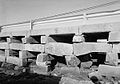
Bailey Island Bridge from Bailey Island, looking toward Orr's Island
Nearest city Harpswell, ME
Coordinates 43°44′57.8″N69°59′18.6″W / 43.749389°N 69.988500°W / 43.749389; -69.988500
NRHP reference No. 75000093 [1]
Added to NRHPApril 28, 1975

The Bailey Island Bridge (also called the Cribstone Bridge) is a historic bridge in the town of Harpswell within Cumberland County in the state of Maine.

Contents

History

For many years, the residents of Bailey Island, Maine, advocated that a bridge be built to connect their island with Orr's Island. [2] The town of Harpswell, Maine, which encompasses both islands, turned down the request. However, when the Maine Legislature drafted a law allowing the state and counties to fund bridge construction, a plan emerged to build such a bridge. A contract was signed in 1926, with construction beginning on the Bailey Island Bridge in 1927 and finishing in 1928. The engineer for the project was Llewelyn N. Edwards, bridge engineer for the Maine State Highway Commission. [2]

Design

Cribstones used in the cobwork construction of the bridge Bailey Island Bridge, Harpswell, ME - IMG 7901.JPG
Cribstones used in the cobwork construction of the bridge

Design of the 1,150-foot-long (350 m) bridge was complicated by the tides in the area known as Will's Gut. It was decided to build a cobwork bridge, using granite slabs as cribstones, acquired from local quarries in nearby Yarmouth, Maine. The slabs allowed the tide to ebb and flow freely without increasing tidal current to any great degree. [3]

Some 10,000 tons of granite were used in the project. A concrete road (now part of Route 24) was built on top of the cribstones.

Additions and recognition

A sidewalk was added in 1951 and guard rails in 1961. The Bailey Island Bridge was listed on the National Register of Historic Places in 1975; on July 19, 1984, it was recognized as a National Historic Civil Engineering Landmark. The Bailey Island Bridge is reported to be the only granite cribstone bridge in the world. [2] [4]

In 2009 and 2010, the bridge underwent reconstruction to repair cracked or sheared stones. [5] During the repairs, a 1,000-foot-long (300 m) temporary bridge was placed alongside the cribstone bridge so that traffic could continue without disruption. On November 20, 2010, a ribbon-cutting ceremony and parade took place to celebrate the reopening of the bridge. [6] The restored bridge maintains the dimensions of the original, and the replacement stones were obtained from the same quarry in Yarmouth that supplied the original.

See also

Related Research Articles

<span class="mw-page-title-main">National Road</span> Early American improved highway

The National Road was the first major improved highway in the United States built by the federal government. Built between 1811 and 1837, the 620-mile (1,000 km) road connected the Potomac and Ohio Rivers and was a main transport path to the West for thousands of settlers. When improved in the 1830s, it became the second U.S. road surfaced with the macadam process pioneered by Scotsman John Loudon McAdam.

<span class="mw-page-title-main">Harpswell, Maine</span> Town in the state of Maine, United States

Harpswell is a town in Cumberland County, Maine, United States, within Casco Bay in the Gulf of Maine. The population was 5,031 at the 2020 census. Harpswell is composed of land contiguous with the rest of Cumberland County, called Harpswell Neck, as well as three large islands connected by bridges: Sebascodegan Island, Orr's Island, and Bailey Island and over 200 smaller islands. Harpswell is part of the Portland–South Portland–Biddeford, Maine Metropolitan Statistical Area.

<span class="mw-page-title-main">Chebeague Island, Maine</span> Town in Maine, United States

Chebeague Island is located in Casco Bay, an inlet of the Gulf of Maine. It was originally used as a fishing ground by Abenaki Native Americans. Also known as Great Chebeague Island, today it is a town in Cumberland County, Maine, United States. It is located 10 miles (16 km) northeast of Portland, Maine. Chebeague Island is the largest island in Casco Bay that is not connected to the mainland by a bridge. The largest island is Sebascodegan, or "Great Island," which is part of the Town of Harpswell and connected to the mainland by a bridge.

<span class="mw-page-title-main">Granite Railway</span> Railroad between Quincy and Milton, Massachusetts

The Granite Railway was one of the first railroads in the United States, built to carry granite from Quincy, Massachusetts, to a dock on the Neponset River in Milton. From there boats carried the heavy stone to Charlestown for construction of the Bunker Hill Monument. The Granite Railway is popularly termed the first commercial railroad in the United States, as it was the first chartered railway to evolve into a common carrier without an intervening closure. The last active quarry closed in 1963; in 1985, the Metropolitan District Commission purchased 22 acres (8.9 ha), including Granite Railway Quarry, as the Quincy Quarries Reservation.

<span class="mw-page-title-main">Bailey Island (Maine)</span> Island in the United States

Bailey Island is an island in Casco Bay, and a part of the town of Harpswell, in Cumberland County, Maine, United States. As of the 2000 census, the island had a year-round population of 400.

<span class="mw-page-title-main">Fort Gorges</span> United States historic place

Fort Gorges is a former United States military fort built on Hog Island Ledge in Casco Bay, Maine, United States. Built from 1858 to 1864, no battles were fought there and no troops were stationed there. Advancing military technology, including iron clad ships and long range guns, rendered the fort obsolete before it could be used. The fort is now a park, accessible only by boat. It was added to the National Register of Historic Places in 1973.

<span class="mw-page-title-main">Bollman Truss Railroad Bridge</span> Historic truss bridge in Savage, Maryland, US

The Bollman Truss Railroad Bridge across the Little Patuxent River at Savage, Maryland, is one of the oldest standing iron railroad bridges in the United States and the sole surviving example of a revolutionary design in the history of American bridge engineering. The 160-foot (48.8 m) double-span was built in 1852 at an unknown location on the main line of the Baltimore and Ohio Railroad. It was moved 35 years later to its present location, where it replaced the very first Bollman bridge. Today, it carries the Savage Mill Trail.

<span class="mw-page-title-main">Thomas Viaduct</span> Railroad bridge in Maryland, US

The Thomas Viaduct spans the Patapsco River and Patapsco Valley between Relay, Maryland and Elkridge, Maryland, USA. It was commissioned by the Baltimore and Ohio Railroad (B&O); built between July 4, 1833, and July 4, 1835; and named for Philip E. Thomas, the company's first president. Some claim it to be the world's oldest multiple arched stone railroad bridge. However, the Sankey Viaduct on the Liverpool and Manchester Railway was opened in 1830, and finally completed in 1833.

<span class="mw-page-title-main">Canton Viaduct</span> Railroad viaduct in Massachusetts, U.S.

Canton Viaduct is a blind arcade cavity wall in Canton, Massachusetts, built in 1834–35 for the Boston and Providence Railroad.

<span class="mw-page-title-main">Bailey Island Library Hall</span> United States historic place

Bailey Island Library Hall is a historic community building at 2167 Harpswell Island Road, on Bailey Island in Harpswell, Maine. Built in 1911–12, it has been a center of community life on the island since its construction, and is a notable architectural work of the New York City architectural firm Mann & MacNeille. Originally built to house a lending library and social hall, it now only serves the latter function. It was listed on the National Register of Historic Places on December 31, 2008.

<span class="mw-page-title-main">Union Arch Bridge</span> Historic masonry structure in Maryland, U.S.

The Union Arch Bridge, also called the "Cabin John Bridge", is a historic masonry structure in Cabin John, Maryland. It was designed as part of the Washington Aqueduct. The bridge construction began in 1857 and was completed in 1864. The roadway surface was added later. The bridge was designed by Alfred Landon Rives, and built by the United States Army Corps of Engineers under the direction of Lieutenant Montgomery C. Meigs.

<span class="mw-page-title-main">Harpswell Meetinghouse</span> Historic church in Maine, United States

The Harpswell Meetinghouse is a historic colonial meeting house on Maine State Route 123 in Harpswell, Maine. Built in 1757-59 to provide space for both religious services and town meetings, it is a little-altered and well-preserved example of a once-common form, and is the oldest such surviving building in the state of Maine. It was designated a National Historic Landmark in 1968.

<span class="mw-page-title-main">Casselman Bridge</span> State park in Maryland, United States

The Casselman Bridge is a historic transportation structure on the Casselman River, located immediately east of Grantsville in Garrett County, Maryland. The bridge was built in 1813-1814 as part of the National Road. Historic markers posted at each end read:

Erected 1813 by David Shriver, Jr.,
Sup't of the "Cumberland Road". This 80 foot span
was the largest stone arch in America
at the time. It was continuously
used from 1813 to 1933.

<span class="mw-page-title-main">Bartlett's Bridge</span> United States historic place

Bartlett's Bridge is a historic stone arch bridge carrying Clara Barton Road over the French River in Oxford, Massachusetts. Built in 1889, it is a rare example of late 19th-century stone bridge construction in the state. It was originally built to provide improved capacity for vehicles servicing a nearby textile mill complex. The bridge was listed on the National Register of Historic Places in 2000.

<span class="mw-page-title-main">Contoocook Railroad Bridge</span> United States historic place

The Contoocook Railroad Bridge is a covered bridge on the former Contoocook Valley Railroad line spanning the Contoocook River in the center of the village of Contoocook, New Hampshire, United States. It is referred to in the National Register of Historic Places as the Hopkinton Railroad Covered Bridge, for the town of Hopkinton, New Hampshire, in which the village of Contoocook is located.

<span class="mw-page-title-main">Stone House (Bridgton, Maine)</span> Historic house in Maine, United States

The Stone House is an historic house located on Burnham Road in Bridgton, Maine, United States. Built 1828–1830, it is a rare example in Maine of a Cape style house built out of stone in the English masonry style. It was listed on the National Register of Historic Places in 1984.

<span class="mw-page-title-main">Yarmouth, Maine</span> Town in the state of Maine, United States

Yarmouth is a town in Cumberland County, Maine, United States, twelve miles north of the state's largest city, Portland. When originally settled in 1636, as North Yarmouth, it was part of the Massachusetts Bay Colony, and remained part of its subsequent incarnations for 213 years. In 1849, twenty-nine years after Maine's admittance to the Union as the twenty-third state, it was incorporated as the Town of Yarmouth.

<span class="mw-page-title-main">New Portland Wire Bridge</span> United States historic place

The New Portland Wire Bridge is a historic suspension bridge in New Portland, Maine. The bridge carries Wire Bridge Road across the Carrabassett River a short way north of the village center. Built in the mid-19th century, it is one of four 19th-century suspension bridges in the state. It is one lane wide, and has a weight limit of 3 tons. The bridge was listed on the National Register of Historic Places in 1970 and was designated as a Maine Historic Civil Engineering Landmark by the American Society of Civil Engineers in 1990.

The Great Chebeague Golf Club is a country club at 16 Stone Wharf Road on Chebeague Island, Maine. It has a nine-hole golf course on more than 28 acres (11 ha) on the north side of the island. Its clubhouse is a repurposed circa 1807 residence, which is probably one of the oldest buildings used for that purpose in the nation. The club was listed on the National Register of Historic Places in 2015.

<span class="mw-page-title-main">Songo Lock</span> United States historic place

Songo Lock is the last surviving lock of the Cumberland and Oxford Canal, a 19th-century canal in southern Maine, United States. The lock is located on the Songo River, just above its confluence with the Crooked River at the northern end of Sebago Lake State Park in the town of Naples. The lock, built in 1830, is now used primarily during the summer months by pleasure craft. It was listed on the National Register of Historic Places in 1970 and designated as a Maine Historic Civil Engineering Landmark by the American Society of Civil Engineers in 2001.

References

  1. "National Register Information System". National Register of Historic Places . National Park Service. January 23, 2007.
  2. 1 2 3 Hansen, Brett (January 2009). "Stacking Stones:The Bailey Island Bridge" (PDF). Civil Engineering. Reston, Virginia: American Society of Civil Engineers. 79 (1): 34–35. ISSN   0885-7024. Proposals were made many times in the 18th and 19th centuries to construct a bridge.
  3. Frank Beard (December 17, 1974). "National Register of Historic Places Inventory - Nomination Form: Bailey Island Cobwork Bridge" (PDF). National Park Service . Retrieved December 29, 2015. Accompanying two photos.
  4. "Bailey Island Bridge Historical Marker". The Historical Marker Database. Retrieved September 5, 2021.
  5. "Cribstone Bridge Undergoing Repairs".[ permanent dead link ]
  6. Delage, Sarah (November 20, 2010). "Community celebrates historic bridge restoration". WCSH. Archived from the original on February 9, 2013. Retrieved 2010-11-20.

Further reading