
North Mountain is a peak in the Catskill Mountains of New York, on the border between the towns of Catskill and Hunter, in Greene County. It is part of the Catskill Escarpment. Cairo Round Top is located northeast and Artists Rock is located southeast of North Mountain.

Pisgah National Forest is a National Forest in the Appalachian Mountains of western North Carolina. It is administered by the United States Forest Service, part of the United States Department of Agriculture. The Pisgah National Forest is completely contained within the state of North Carolina. The forest is managed together with the other three North Carolina National Forests from common headquarters in Asheville, North Carolina. There are local ranger district offices located in Pisgah Forest, Mars Hill, and Nebo.
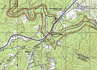
Balsam Gap is a mountain pass between the Plott Balsam Range to the northwest and the Great Balsam Mountains to the southeast on the county line dividing Haywood and Jackson counties in the U.S. state of North Carolina.

Waterrock Knob is a mountain peak in the U.S. state of North Carolina. It is the highest peak in the Plott Balsams and is the 16th-highest mountain in the Eastern United States.

Balsam is an unincorporated community in Jackson County, North Carolina, United States. Named after the Balsam Mountains, it is home of the highest standard-gauge railroad east of the Rocky Mountains, at 3,315 feet (1,010 m).

Black Balsam Knob, also known as Black Balsam Bald, is in the Pisgah National Forest southwest of Asheville, North Carolina, near milepost 420 on the Blue Ridge Parkway. It is the second highest mountain in the Great Balsam Mountains. The Great Balsams are within the Blue Ridge Mountains, which are part of the Appalachian Mountains. It is the 23rd highest of the 40 mountains in North Carolina over 6000 feet.

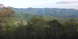
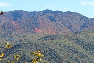
The Great Balsam Mountains, or Balsam Mountains, are in the mountain region of western North Carolina, United States. The Great Balsams are a subrange of the Blue Ridge Mountains, which in turn are a part of the Appalachian Mountains. The most famous peak in the Great Balsam range is Cold Mountain, which is the centerpiece of author Charles Frazier's bestselling novel Cold Mountain. Other notable peaks include Richland Balsam, which is the highest peak in the range, Black Balsam Knob, and Mount Pisgah.

Balsam Mountain is one of the High Peaks of the Catskill Mountains in the U.S. state of New York. Its exact height has not been determined, so the highest contour line, 3,600 feet (1,100 m), is usually given as its elevation. It is located in western Ulster County, on the divide between the Hudson and Delaware watersheds. The summit and western slopes of the peak are within the Town of Hardenburgh and its eastern slopes are in Shandaken. The small community of Oliverea is near its base on that side. Most of the mountain is publicly owned, managed by the New York State Department of Environmental Conservation as part of the state Forest Preserve, part of the Big Indian-Beaverkill Range Wilderness Area in the Catskill Park. The summit is on a small corner of private land.

Balsam Lake Mountain is one of the Catskill Mountains, located in the Town of Hardenburgh, New York, United States. It is the westernmost of the range's 35 High Peaks. Its exact height has not been determined, but the highest contour line on topographic maps, 3,720 feet (1,130 m), is usually given as its elevation.

Graham Mountain is the seventh highest of the Catskill High Peaks and the highest privately owned mountain in the range. It is located in the town of Hardenburgh, New York, United States.

Balsam Cap is a mountain located in Ulster County, New York. The mountain is part of the Catskill Mountains. Balsam Cap is flanked to the north by Friday Mountain, and to the southwest by Rocky Mountain.
Friday Mountain is a mountain located in Ulster County, New York. The mountain is part of the Catskill Mountains. Friday Mountain is flanked to the north by Cornell Mountain, and to the south by Balsam Cap.

Marks Knob is a mountain in the central Great Smoky Mountains, in the southeastern United States. It has an elevation of 6,169 feet (1,880 m), with 249 feet (76 m) of clean prominence. Its summit is a popular bushwhacking destination and one of the most difficult-to-reach summits of the Southern Sixers.
The Plott Balsams are a mountain range in western North Carolina in the southeastern United States.
Eaglenest Mountain is a mountain located 2 miles south of Maggie Valley, North Carolina in Haywood County. It is part of the Plott Balsams, a range of the Appalachian Mountains, and less than a mile south of North Eaglenest Mountain, a higher mountain which used to be called Mount Junaluska and is the highest mountain overlooking Lake Junaluska from the southwest. The closest town that is accessible by road is Hazelwood. Hazelwood was absorbed into the larger incorporated Town of Waynesville in 1995.
Richland Balsam is a mountain in the Great Balsam Mountains in the U.S. state of North Carolina. Rising to an elevation of 6,410 feet (1,950 m), it is the highest mountain in the Great Balsam range, is among the 20 highest summits in the Appalachian range, and is the ninth highest peak in the Eastern United States. The Blue Ridge Parkway reaches an elevation of 6,053 feet (1,845 m)—the parkway's highest point—as it passes over Richland Balsam's southwestern slope. The Jackson County-Haywood County line crosses the mountain's summit.

The southern Appalachian spruce–fir forest is an ecoregion of the temperate coniferous forests biome, a type of montane coniferous forest that grows in the highest elevations in the southern Appalachian Mountains of the eastern United States. The ecoregion is the highest and coldest forest type in the Appalachian range, thriving in elevations above 5,500 feet (1,700 m) where the climate is too harsh to support the broad-leaved hardwood forest that dominates the region's lower elevations. A relict of the last Ice Age, this forest type covers just over 100 square miles (260 km2) and is considered to be among the most endangered ecosystems in the United States.

The Balsam Lake Mountain Fire Observation Station is located at the summit of the mountain of that name in the Town of Hardenburgh, New York, United States. It comprises a steel frame fire lookout tower, the observer's cabin and privy and the jeep road to the complex.
Breath Hill is a mountain located in the Catskill Mountains of New York southwest of West Shokan. Little Rocky is located southeast, and Balsam Cap is located north of Breath Hill.
Hirams Knob is a mountain located in the Catskill Mountains of New York southeast of Mapledale. Balsam Lake Mountain is located southwest, and Haynes Mountain is located southeast of Hirams Knob.

