
Watauga County is a county located in the U.S. state of North Carolina. As of the 2020 census, the population was 54,086. Its county seat and largest community is Boone. The county is in an exceptionally mountainous region, known as the High Country. It is the home of Appalachian State University, which has approximately 21,570 students as of Fall 2024. Watauga County comprises the Boone, NC Micropolitan Statistical Area.

Madison County is a county located in the U.S. state of North Carolina. As of the 2020 census, the population was 21,193. Its county seat is Marshall. Madison County is part of the Asheville, NC Metropolitan Statistical Area.

Indian Lake is a town in Hamilton County, New York, United States. The population was 1,352 at the 2010 census. The name is from a lake of the same name that is largely inside the town. There are no permanent stop lights in the town. Law enforcement is provided by New York State Troopers and Hamilton County Sheriff's Office.

Edinburg is a town in northwestern Saratoga County, New York, United States. It is located in the Adirondack Park. The Batchellerville Bridge crosses Great Sacandaga Lake, connecting parts of the town on either shore.

Beech Mountain is a town in both Avery and Watauga counties in the U.S. state of North Carolina. At the 2020 census, the town population was 675. The town is located atop Beech Mountain and is the highest town east of the Rocky Mountains at 5,506 ft (1,678 m) in elevation. The nearest municipality at a higher elevation is Des Moines, New Mexico, some 1,220 miles away.
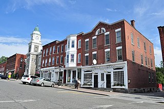
Litchfield is a town in and former county seat of Litchfield County, Connecticut, United States. The population was 8,192 at the 2020 census. The town is part of the Northwest Hills Planning Region. The boroughs of Bantam and Litchfield are located within the town. There are also three unincorporated villages: East Litchfield, Milton, and Northfield. Northfield, located in the southeastern corner of Litchfield, is home to a high percentage of the Litchfield population.

The Litchfield Hills are a geographic region of the U.S. state of Connecticut located in the northwestern corner of the state. It is roughly coterminous with the boundaries of Litchfield County, for which it is named. The geographic region includes colloquial subregions—rural Northwestern Connecticut and the area associated with the city of Torrington, also known as the Upper Naugatuck River Valley or simply Litchfield Hills—which have also variously corresponded to designated government councils both past and present. Much of the area makes up the lowermost section of the Berkshires and is culturally similar to the rest of western New England.

Washington Township is located in Will County, Illinois. As of the 2010 census, its population was 6,263 and it contained 2,404 housing units. Washington Township was formed from Crete Township and Sherburn Township on an unknown date.

Baktakék is a village in Borsod-Abaúj-Zemplén county, Hungary.

Vly Mountain is a mountain located in the town of Halcott, New York, United States in Greene County. The mountain is part of the Catskill Mountains. Vly Mountain is flanked to the northwest by Bearpen Mountain, to the east by Vinegar Hill, to the northeast by Kipp Hill, and to the southeast by Beech Ridge.
Rich Mountain is a mountain located in the North Carolina High Country, roughly 3 miles (4.8 km) northwest of the town of Boone. Its elevation reaches 4,748 feet (1,447 m).

Rum Hill is a mountain located in Central New York Region of New York northwest of the Hamlet of Pierstown. Red House Hill is located southeast, Metcalf Hill is located south, Allen Lake and Mohegan Hill are located north-northwest and Otsego Lake is located east of Rum Hill.
Kilkenny Hill is a mountain in the Central New York region of New York, United States. It is located northwest of Unadilla, New York. Kilkenny Hill is part of the Northern Allegheny Plateau Ecoregion.
Tanner Hill is a summit located in Central New York Region of New York located in the Town of Newport in Herkimer County, west-northwest of Middleville. Beech Hill is located south-southwest of Tanner Hill.
Beech Ridge is a ridge located in Greene County, New York southwest of Lexington, New York. Located to the northwest is Vly Mountain and to the north of Vinegar Hill. Beech Ridge drains north into Beech Ridge Brook, east into West Kill and south into Condon Hollow.
Gallis Hill is a 794-foot-tall (242 m) mountain in the Catskill Mountains region of New York. It is located northwest of Kingston in Ulster County. Jockey Hill is located north-northeast, and Morgan Hill is located west of Gallis Hill. In 1927, the Conservation Department built a steel fire lookout tower on the mountain. In 1950, the tower was closed and disassembled then moved to Overlook Mountain, where it still remains today.
Leonard Hill is a 2,592-foot-tall (790 m) mountain in Schoharie County, New York. It is located east-southeast of North Blenheim. Safford Hill is located northwest and Hubbard Hill is located southeast of Leonard Hill. In 1948, the Conservation Commission built an 80-foot-tall (24 m) steel fire lookout tower on the mountain. The tower ceased fire watching operations at the end of the 1988 season and was officially closed in early 1989. The tower remains on the summit, but is closed to the public. A local group is planning to restore the tower and reopen it to the public.
Rattle Hill is a mountain in Sullivan County, New York. It is located north-northwest of Grooville. Beech Mountain is located east-northeast, Burnt Hill is located west-southwest and Gray Hill is located south-southwest of Rattle Hill.
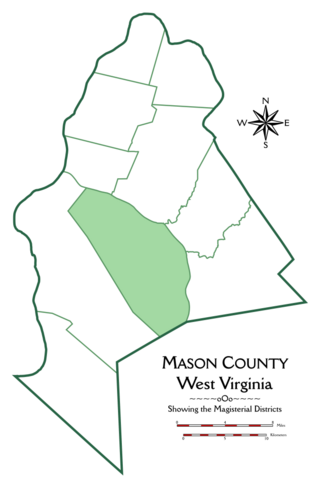
Arbuckle Magisterial District is one of ten magisterial districts in Mason County, West Virginia, United States. The district was originally established as a civil township in 1863, and converted into a magisterial district in 1872. In 2020, Arbuckle District was home to 1,054 people.

Cerro del Diablo is a mountain in the municipality of Ponce, Puerto Rico, located north-northwest of the city of Ponce. The 2,234-foot high hill sits at the foothills of the Cordillera Central and is located in Barrio Tibes.

