Related Research Articles

Shivaji I was an Indian ruler and a member of the Bhonsle dynasty. Shivaji carved out his own independent kingdom from the Sultanate of Bijapur that formed the genesis of the Maratha Confederacy.

Belgaum, officially known as Belagavi, is a city in the Indian state of Karnataka located in its northern part along the Western Ghats. It is the administrative headquarters of the eponymous Belagavi division and Belagavi district. The Government of Karnataka has proposed making Belgaum the second capital of Karnataka alongside Bangalore, hence a second state administrative building Suvarna Vidhana Soudha was inaugurated on 11 October 2012.

Bijapur is the district headquarters of Bijapur district of the Karnataka state of India. It is also the headquarters for Bijapur Taluk. Bijapur city is well known for its historical monuments of architectural importance built during the rule of the Adil Shahi dynasty. It is also well known for the popular Karnataka premier league team, the Bijapur Bulls. Bijapur is located 519 km (322 mi) northwest of the state capital Bangalore and about 550 km (340 mi) from Mumbai and 210 km (130 mi) north east of the city of Belgaum.

Sinhagad is an ancient hill fortress located at around 49 km southwest of the city of Pune, India.

Sangli district is a district of Maharashtra state in India. Sangli city is the district headquarters. It is bordered by Satara district, Solapur district to the North, Karnataka state to the South-East, by Kolhapur district to South-West and by narrow portion on the East side to Ratnagiri district. It is present on the southern tip of Maharashtra.

North Karnataka is a geographical region in Deccan plateau from 300 to 730 metres elevation that constitutes the region of the Karnataka state in India and the region consists of 14 districts. It is drained by the Krishna River and its tributaries the Bhima, Ghataprabha, Malaprabha, and Tungabhadra. North Karnataka lies within the Deccan thorn scrub forests ecoregion, which extends north into eastern Maharashtra.
Khanapur known as Khanapura is a panchayat town in Belagavi district, Karnataka, India. It is about 26 km from Belagavi, the administrative capital of the district. The Khanapur Municipal Council governs the town. Khanapur is the headquarters for Khanapur taluk. The town is on the Belgaum-Panaji National Highway, NH 4A. Khanapur is well connected by train and road to important cities in Karnataka, Goa, and Maharashtra. Kannada is the official language.

Karnataka, the sixth largest state in India, was ranked as the third most popular state in the country for tourism in 2014. It is home to 507 of the 3600 centrally protected monuments in India, second only to Uttar Pradesh. The State Directorate of Archaeology and Museums protects an additional 752 monuments and another 25,000 monuments are yet to receive protection.

Bhagwan Mahaveer Sanctuary and Mollem National Park is a 240 square kilometres (93 sq mi) protected area located in the Western Ghats of West India, in Dharbandora taluk, Goa State, along the eastern border with Karnataka. The area is situated near the town of Molem, 57 kilometres (35 mi) east of Panaji, the state capital of Goa. National Highway 4A divides it into two parts and the Mormugao - Londa railway line passes through the area. It is located between 15°15"30' to 15°29"30' N and 74°10"15' to 74°20"15' E. It contains several important temples dating to the Kadambas of Goa, and home to waterfalls, such as Dudhsagar Falls and Tambdi Falls. The parkland is also home to a community of nomadic buffalo herders known as the Dhangar.
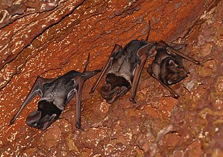
Wroughton's free-tailed bat is a free-tailed bat formerly considered to be confined to the Western Ghats area of India, though it has also recently been discovered in northeast India and in a remote part of Cambodia. It is classified as a Data Deficient species as little is known about their habitat, ecology, or foraging range.

Belawadi Mallamma (1624–1678) was a warrior queen from the Belawadi province in present-day Karnataka, India. She is known for her leadership and resistance against invaders during a period of significant conflict in the region.

Purandar Fort is a mountain fort in Pune district in Western Indian state of Maharashtra, India. The fort stands at 1,374 metres (4,508 ft) above the sea level in the Western Ghats, 50 kilometres (31 mi) to the southeast of Pune.

Sadashivgad or Sadashivagada is a village located in Karwar, Uttara Kannada district, in the state of Karnataka in India. Significant and picturesque, it is now a popular tourist destination located by the Kali river bridge, which has been built at the confluence of the river and the Arabian Sea.

Belgaum Fort is in the city of Belgaum, in the Belgaum district, in Karnataka state, India. It was begun by Jaya Raya, also called Bichi Raja, an ally of the Ratta Dynasty, in the year 1204. It has undergone several renovations over the centuries under dynastic rulers of the region.
Bhimgad Wildlife Sanctuary is a protected area in the Western Ghats, in Khanapur Taluk of Belgavi District near Jamboti Village, Karnataka state, India. This 19,042.58 ha (73.5238 sq mi) of Tropical and subtropical moist broadleaf forests forest area was long awaiting to be a wild life sanctuary and finally declared in December 2011.

The Mhadei Wildlife Sanctuary is a 208.5-km2 (80.5-mi2) protected area in the Indian state of Goa in the Western Ghats of South India. It is located in the North Goa District, Sattari taluka near the town of Valpoi. The sanctuary is an area of high biodiversity, and is being considered to become a Project Tiger tiger reserve because of the presence of Bengal tigers.
Nirmal Ulhas Kulkarni is a herpetologist, field ecologist, conservationist, and wildlife photographer. Director (Ecology) of Wildernest Nature Resort, an eco-tel in the Chorla Ghats (Goa), Chairman of the Mhadei Research Centre, Team Lead of Hypnale Research Station and promoter of HERPACTIVE, a study initiative on Herpetofauna. As of December 2012, he lives in Goa.

Tourism in India is economically significant and projected to continue a pattern of growth. In 2016, the World Travel & Tourism Council calculated that tourism generated ₹14.02 lakh crore (US$160 billion) or 9.6% of the nation's GDP and supported 40.343 million jobs, 9.3% of its total employment. The sector is predicted to grow at an annual rate of 6.8% to ₹28.49 lakh crore (US$330 billion) by 2027.
Mahipalgad Fort is a fort located 20 km (12 mi)from Belgaum. It is in the Chandgad taluka of Kolhapur district, of Maharashtra. This fort is an important fort in Kolhapur district. The fort is situated on the mountain ridge close to the line dividing Maharashtra and Karnataka state. The fort is amidst dense evergreen forest.
Vallabhgad Fort is a fort located 57 km (35 mi)from Belgaum. It is in the Hukkeri taluka of Belgaum district, of Karnataka. This fort is an important fort in Belgaum district. The fort is situated on the Khadya hill mountain ridge close to the Pune-Bangalore national Highway.
References
- 1 2 3 Bimgad Fort. Vol. 21. Bombay: Government Central Press. 1877. pp. 9, 552. Retrieved 14 January 2012.
{{cite book}}:|work=ignored (help) - 1 2 Purandare, Babasaheb (August 2003). "Raja Shivachhatrapati (Marathi: राजा शिवछत्रपती)" (15th ed.). Pune: Purandare Prakashan.
{{cite journal}}: Cite journal requires|journal=(help)