
Shenandoah Mountain is a mountain ridge approximately 73 miles (117 km) long in Virginia and West Virginia. The steep, narrow, sandstone-capped ridge extends from northern Bath County, Virginia to southern Hardy County, West Virginia. Along the way, its crest defines the borders between Highland and Augusta counties, Virginia, and between Pendleton County, West Virginia, and Rockingham County, Virginia. Its high point is 4397’/1340 m Reddish Knob along the Virginia/West Virginia border.

Mill Creek Mountain is a continuous mountain ridge that runs northeast through Hampshire and Hardy counties in the Eastern Panhandle region of the U.S. state of West Virginia. Rising to its greatest elevation of 2,650 feet (808 m) at High Knob, Mill Creek is a folded mountain ridge, belonging to the Ridge-and-Valley Appalachians. Mill Creek Mountain forms the western edge of the South Branch Potomac River Valley and is named for Mill Creek that carves through it at Mechanicsburg Gap allowing the Northwestern Turnpike to pass through as well. Along with Sawmill Ridge, Mill Creek Mountain forms the Trough along the South Branch.
Patterson Creek Mountain is a mountain ridge that forms the border between Mineral and Hampshire counties and Grant and Hardy Counties in West Virginia's Eastern Panhandle. The mountain's namesake, Patterson Creek, parallels its western flank. The southern end of the Patterson Creek Mountain is near the confluence of Lunice Creek and the South Branch Potomac River and its northern end is located southwest of Springfield. The mountain reaches its highest elevation at Charles Knob.
Dorsey Knob is a mountain summit located off U.S. Route 119 at the southern edge of Morgantown in Monongalia County, West Virginia, United States. Dorsey Knob is contained within a park spanning 71 acres that features the mountain's landmark Sky Rock. The top of Sky Rock is at an altitude of 1,398 feet (426 m), rising nearly 600 feet above the surrounding landscape. It overlooks the Monongahela River and the Appalachian Mountains. Also located in the park is Dorsey's Knob Lodge, operated by Boparc, Morgantown's municipal park authority.

Roan Mountain is a 6,277 ft (1,913 m) mountain straddling the North Carolina/Tennessee border in the Unaka Range of the Southern Appalachian Mountains in the Southeastern United States. The range's highpoint, Roan is clad in a dense stand of Southern Appalachian spruce-fir forest, and includes the world's largest natural rhododendron garden, and the longest stretch of grassy bald in the Appalachian range. The Roan Highlands also contain the highest quality remaining stretch of Fraser fir forest throughout the tree's entire range. The Cherokee National Forest and Pisgah National Forest converge atop the mountain, with Roan Mountain State Park located near its northern base. The Appalachian Trail traverses most of the Roan's crest. The Roan High Knob Shelter is the highest back-country shelter on the entire 2,174-mile (3,499 km) trail.

Waterrock Knob is a mountain peak in the U.S. state of North Carolina. It is the highest peak in the Plott Balsams and is the 16th-highest mountain in the Eastern United States.

Blue Knob is a summit in the eastern United States with a broad dome that is the northernmost 3,000-footer in the Allegheny Mountains. It is the highest point in Bedford County, Pennsylvania.

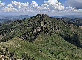
Big Mountain is the high point on the Tuscarora Mountain ridge in south central Pennsylvania in the United States. The 2,458-foot (749 m) summit is located in the Buchanan State Forest and offers a viewshed that is one of the more stunning in the Commonwealth.

Butler Knob is a peak on the Jacks Mountain ridge in south central Pennsylvania in the United States. The "Knobs" summit is underlain with weather resistant quartzite of the Tuscarora Formation. Butler Knob is accessible by a rough road, where there is a closed firetower on the summit. The firetower presently hold a weather station that gives current forecasts for the area.
Salt Pond Mountain is a mountain located in Giles County, Virginia. The mountain, which is part of the Ridge-and-valley province of the Appalachian Mountains, extends about seven miles (12 km) from southwest to northeast. The highest peak is Bald Knob, at the southeast end, south of Mountain Lake. Salt Pond Mtn. joins Johns Creek Mountain at the southwest end, and the Big Mountain – Potts Mountain ridge at the northeast end, just south of West Virginia.

In peak bagging terminology in the United States, the Southern Sixers refers to the group of mountains in the southern states of North Carolina and Tennessee with elevations above sea level of at least six thousand feet. The southern sixers are the tallest group of mountains in the eastern United States and the only peaks in the Appalachian Mountains besides New Hampshire's Mount Washington to exceed 6,000 feet.

Spruce Mountain, located in eastern West Virginia, is the highest ridge of the Allegheny Mountains. The whale-backed ridge extends for only 16 miles (26 km) from northeast to southwest, but several of its peaks exceed 4,500 feet (1,400 m) in elevation. The summit, Spruce Knob, is the highest Allegheny Mountain point both in the state and the entire range, which spans four states.
Mombaccus Mountain is located in the Catskill Mountains of New York. To the south, it looms over the hamlet of Samsonville in the town of Olive. Together with Little Rocky and South Mountain, Mombaccus Mountain is part of a massif dominated by Ashokan High Point. Below its north slope is the Kanape Brook trail, an old wagon road that leads to a saddle between Mombaccus and Ashokan High Point. Big Rosy Bone Knob, a lesser summit, lies southwest of Mombaccus Mountain. According to historian DeWitt Davis, Mombaccus was "noted for huckleberries and bears" and bear traps were dug on its slopes.
Little Rocky is a mountain located in the Catskill Mountains of New York. It is part of a massif that includes Ashokan High Point, Mombaccus Mountain and South Mountain in West Shokan. Hanover Mountain is located north, Breath Hill is located northwest, and Big Rosy Bone Knob is located southwest of Little Rocky.
Bump Mountain is a mountain located in the Catskill Mountains of New York northeast of Ashland. Richtmyer Peak is located north-northeast, The Knob is located west, and Ashland Pinnacle is located west-southwest of Bump Mountain.
The Knob is a mountain in Greene County, New York. It is located in the Catskill Mountains north-northeast of Ashland. Ashland Pinnacle is located north, and Huntersfield Mountain is located northwest of The Knob. The mountain has an elevation of 2,638 feet.

Haw Knob is a mountain located in the central Unicoi Mountains in the southeastern United States. The peak is located in Monroe County, Tennessee and Graham County, North Carolina, and has an elevation of 5,472 feet (1,668 m) above mean sea level. It located near the Cherohala Skyway and is accessible via the Benton MacKaye Trail.
Gobblers Knob is a 10,246-foot elevation (3,123 m) mountain summit located in Salt Lake County, Utah, United States.

