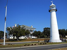
Biloxi is a city in Harrison County, Mississippi, United States. It lies on the Gulf Coast in southern Mississippi, bordering the city of Gulfport to its west. The adjacent cities are both designated as seats of Harrison County. The population of Biloxi was 49,449 at the 2020 census, making it the state's 4th most populous city. It is a principal city of the Gulfport–Biloxi metropolitan area, home to 416,259 residents in 2020. The area's first European settlers were French colonists.

Gulfport is the second-most populous city in the U.S. state of Mississippi after the state capital, Jackson. Along with Biloxi, Gulfport is the co-county seat of Harrison County and part of the Gulfport–Biloxi metropolitan area. As of the 2020 census, Gulfport has a population of 72,926; the metro area has a population of 416,259. Gulfport lies along the gulf coast of the United States in southern Mississippi, taking its name from its port on the Gulf Coast on the Mississippi Sound. It is home to the U.S. Navy Atlantic Fleet Seabees.

Pass Christian, nicknamed The Pass, is a city in Harrison County, Mississippi, United States. It is part of the Gulfport–Biloxi Metropolitan Statistical Area. The population was 6,307 at the 2019 census.

The Beauvoir estate, built in Biloxi, Mississippi, along the Gulf of Mexico, was the post-war home (1876–1889) of the former President of the Confederate States of America Jefferson Davis. The National Park Service designated the house and plantation as a National Historic Landmark.
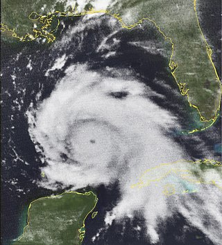
Hurricane Camille was a powerful, deadly and destructive Category 5 major hurricane which became the second most intense tropical cyclone on record to strike the United States and is one of just four Category 5 hurricanes to make landfall in the U.S.

Harrah's Gulf Coast is a casino and hotel in Biloxi, Mississippi, owned by Vici Properties and operated by Caesars Entertainment.
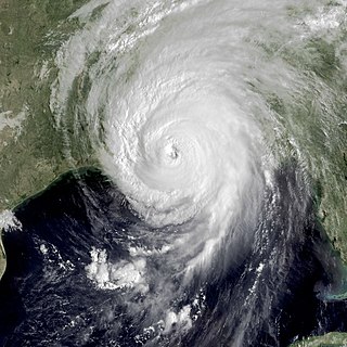
Hurricane Katrina's winds and storm surge reached the Mississippi coastline on the morning of August 29, 2005. beginning a two-day path of destruction through central Mississippi; by 10 a.m. CDT on August 29, 2005, the eye of Katrina began traveling up the entire state, only slowing from hurricane-force winds at Meridian near 7 p.m. and entering Tennessee as a tropical storm. Many coastal towns of Mississippi had already been obliterated, in a single night. Hurricane-force winds reached coastal Mississippi by 2 a.m. and lasted over 17 hours, spawning 11 tornadoes and a 28-foot (8.5 m) storm surge flooding 6–12 miles (9.7–19.3 km) inland. Many, unable to evacuate, survived by climbing to attics or rooftops, or swimming to higher buildings and trees. The worst property damage from Katrina occurred in coastal Mississippi, where all towns flooded over 90% in hours, and waves destroyed many historic buildings, with others gutted to the 3rd story. Afterward, 238 people died in Mississippi, and all counties in Mississippi were declared disaster areas, 49 for full federal assistance. Regulations were changed later for emergency centers and casinos. The emergency command centers were moved higher because all 3 coastal centers flooded at 30 ft (9.1 m) above sea level. Casinos were allowed on land rather than limited to floating casino barges as in 2005.

The Chandeleur Islands are a chain of uninhabited barrier islands approximately 50 miles (80 km) long, located in the Gulf of Mexico, marking the outer boundary of the Chandeleur Sound. They form the easternmost point of the state of Louisiana, United States and are a part of the Breton National Wildlife Refuge. They are an important migrating point for many birds on their way south, and are a prime marsh and forest wildlife area.

Ship Island is a barrier island off the Gulf Coast of Mississippi, one of the Mississippi–Alabama barrier islands. Hurricane Camille split the island into two separate islands in 1969. In early 2019, the US Army Corps of Engineers completed the first stage of a project rejoining the two islands and recreating one Ship Island. Ship Island is the site of Fort Massachusetts, as a Third System fortification. Part of the island is included in the Gulf Islands National Seashore.
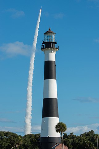
The Cape Canaveral Light is a historic lighthouse on the east coast of the U.S. state of Florida. The light was established in 1848 to warn ships of the dangerous shoals that lie off its coast. It is located inside the Cape Canaveral Space Force Station and managed by the Space Launch Delta 45 of the U.S. Space Force with the assistance of the Cape Canaveral Lighthouse Foundation. It is the only fully operational lighthouse owned by the United States Space Force.

The President Casino Broadwater Resort was a combined casino and resort that was located in Biloxi, Mississippi. It was a fixture on the Mississippi Gulf Coast for over 60 years.
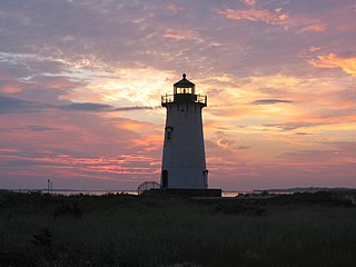
Edgartown Harbor Light is a lighthouse located in Edgartown, Massachusetts, United States, where it marks the entrance to Edgartown Harbor and Katama Bay. It is one of five lighthouses on the island of Martha's Vineyard. The first lighthouse, a two-story wooden structure that also served as the keeper's house, was constructed in 1828. It was demolished, and replaced by the current cast-iron tower, in 1939. Originally located on an artificial island 1/4 miles from shore, the lighthouse is now surrounded by a beach formed, since 1939, by sand accumulating around the stone causeway connecting it to the mainland.
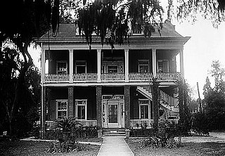
Tullis-Toledano Manor, also known as, the Toledano-Philbrick-Tullis House, was a red-clay brick mansion on the Mississippi Gulf Coast in Biloxi. It was considered an example of Greek Revival architecture. The mansion was added to the National Register of Historic Places in 1976 and was destroyed by Hurricane Katrina in 2005.

Ship Island Light was a lighthouse in Mississippi near Gulfport.

The Chandeleur Island Light was a lighthouse established in 1848 near the northern end of the Chandeleur Islands in the Gulf of Mexico, off the east coast of Louisiana. Hurricane Katrina destroyed the light in 2005.

In 1870, the Louisville and Nashville Railroad was constructed through the southernmost section of Harrison County, Mississippi, connecting New Orleans, Louisiana, and Mobile, Alabama. A northern transportation route into south Mississippi was provided by the Gulf and Ship Island Railroad at the turn of the 20th century. These railroads provided an inexpensive means for moving passengers as well as goods, and opened south Mississippi to both industrial and recreational development. Rapidly progressing lumber and seafood industries transformed the Mississippi Gulf Coast in the 1920s, and people arrived from throughout the United States to take advantage of the economic boom. Northern tourists were attracted to the Mississippi Gulf Coast because of mild winters and cool sea breezes in summer, before the introduction of air conditioning. Besides the weather, other tourist attractions included seafood restaurants, swimming, golf, schooner races, sailing to offshore islands, and recreational fishing. During this period of economic expansion, grand hotels were constructed along the Mississippi Gulf Coast to accommodate businessmen, tourists, and transient workers. Most of these grand hotels no longer exist; and of the two structures that were still standing after the first decade of the 21st century, neither served as a lodging establishment. Together, these grand hotels represented an important era in the history of the Mississippi Gulf Coast throughout the 20th century.

Round Island Lighthouse stood from 1859 to 1998 on the southwest end of Round Island in the Mississippi Sound, 4 miles (6.4 km) south of Pascagoula, Mississippi. In September 1998, the lighthouse was toppled by Hurricane Georges. In 2010, the base of the structure and other lighthouse remnants were removed from Round Island and relocated within the City of Pascagoula for restoration.
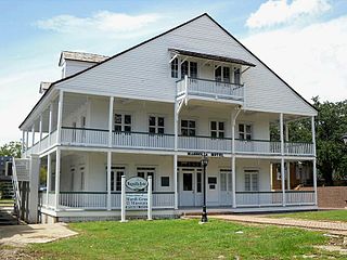
The Magnolia Hotel was built in 1847 to serve as a lodging establishment. It is thought to be the oldest surviving hotel on the Mississippi Gulf Coast. The hotel was added to the National Register of Historic Places in 1973, and was designated a Mississippi Landmark in 1985.

The South Pass Light, also known as the Port Eads LighthouseSouth Point Light, or Gordon's Island Light, are a pair of lighthouses located on Gordon's Island at South Pass, in Plaquemines Parish, Louisiana (USA), one of the primary entrances to the Mississippi River Delta from the Gulf of Mexico. The light station was established in 1831 and is still active.

The Pass A L'Outre Light is a defunct lighthouse in the Birdfoot Delta in Louisiana, United States, located near the mouth of the Mississippi River. Erected to mark the then-active entrance to the river, it was abandoned as that channel silted up. It has been in the path of several noteworthy hurricanes, and was heavily damaged. It is on the Lighthouse Digest Doomsday List, and is critically in danger. The lighthouse is at the center of a nature preserve.
