
The Battle of Blenheim fought on 13 August [O.S. 2 August] 1704, was a major battle of the War of the Spanish Succession. The overwhelming Allied victory ensured the safety of Vienna from the Franco-Bavarian army, thus preventing the collapse of the reconstituted Grand Alliance.
Blenheim is a town in the southwestern part of Schoharie County, New York, United States. It is located east of Oneonta. At the 2020 census, the population was 308. The town was named after a land patent, which itself was named after the Battle of Blenheim.

Gilboa is a town in Schoharie County, New York, United States. The population was 1,111 at the 2020 census.

Blenheim is a town in Marlboro County, South Carolina, United States. The population was 154 at the 2010 census. It is named for Blenheim Palace in Oxfordshire, England. Blenheim Palace was the residence of the Duke of Marlborough, after whom Marlboro County is named.
Blenheim is the English name of Blindheim, a village in Bavaria, Germany, which was the site of the Battle of Blenheim in 1704. Almost all places and other things called Blenheim are named directly or indirectly in honour of the battle.

Blenheim is the most populous town in the region of Marlborough, in the north east of the South Island of New Zealand. It has an estimated urban population of 30,600. The surrounding Marlborough wine region is well known as the centre of the New Zealand wine industry. It enjoys one of New Zealand's sunniest climates, with warm, relatively dry summers and cool, crisp winters.
Valentine Efner was a U.S. Representative from New York, serving one term in office from 1835 to 1837.

The Italian invasion of British Somaliland was part of the East African campaign (1940–1941) in which Italian, Eritrean and Somali forces of Fascist Italy entered the Somaliland Protectorate and defeated its garrison of British, Commonwealth and colonial forces supported by Somali irregulars. The Italian victory was based on mobility and speed but was hampered by the terrain, rainy weather and British resistance.
John Campbell was a U.S. Representative from South Carolina, brother of Robert Blair Campbell.

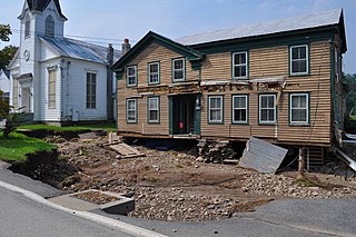
Old Blenheim Bridge was a wooden covered bridge that spanned Schoharie Creek in North Blenheim, New York, United States. With an open span of 210 feet (64 m), it had the second longest span of any surviving single-span covered bridge in the world. The 1862 Bridgeport Covered Bridge in Nevada County, California, currently undergoing repairs due to 1986 flooding is longer overall at 233 feet (71 m) but is argued to have a 208 feet (63 m) clear span. The bridge, opened in 1855, was also one of the oldest of its type in the United States. It was destroyed by flooding resulting from Tropical Storm Irene in 2011. Rebuilding of the bridge commenced in 2017 and was completed in 2018.
North Blenheim is a hamlet in the town of Blenheim, Schoharie County, New York, United States. It had the longest wooden, single-span covered bridge in the United States, the Old Blenheim Bridge. It was built in 1855 and remained intact until 2011, when it was destroyed by flooding caused by Hurricane Irene. The "Blenheim Gilboa Power Project Visitors Center" is also located there. The Blenheim covered bridge has been rebuilt and opened in 2019.
Blenheim is an unincorporated community in Albemarle County, Virginia.
The 2013 Lake Grassmere earthquake was a magnitude 6.6 earthquake that occurred at 2:31:05 pm (NZST) on Friday 16 August 2013. The epicentre was located about 10 km south-east of Seddon, under Lake Grassmere, with a focal depth of 8 km. The earthquake caused significant land damage in the local area, with landslips blocking roads, including the main highway between Blenheim and Christchurch. Buildings in Seddon were damaged, with some being declared uninhabitable. The earthquake was widely felt in both the North and South Islands of New Zealand.

The Clare Valley is a valley located in South Australia about 100 kilometres north of Adelaide in the Clare and Gilbert Valleys council area. It is the river valley formed by the Hutt River but is also strongly associated with the roughly parallel Hill River. The valley is traversed by the Horrocks Highway and the towns in the valley along that route from south to north are Auburn, Leasingham, Watervale, Penwortham, Sevenhill and Clare. The geographical feature has given rise to the Clare Valley wine region designation, a notable winegrowing region of Australia.
Moore Hill is a mountain in Schoharie County, New York. It is located northeast of South Gilboa. Blenheim Hill is located north and Bald Mountain is located west-southwest of Moore Hill.
Rossman Hill is a mountain in Schoharie County, New York. It is located northwest of North Blenheim. Fulton Hill is located northwest, Towpath Mountain is located east-northeast, and Burnt Hill is located south of Rossman Hill.
Brown Mountain is a mountain in Schoharie County, New York. It is located southeast of North Blenheim. Reed Hill is located southwest and Safford Hill is located northeast of Brown Mountain.
Safford Hill is a mountain in Schoharie County, New York. It is located east of North Blenheim. Brown Mountain is located southwest and Leonard Hill is located southeast of Safford Hill.
Leonard Hill is a 2,592-foot-tall (790 m) mountain in Schoharie County, New York. It is located east-southeast of North Blenheim. Safford Hill is located northwest and Hubbard Hill is located southeast of Leonard Hill. In 1948, the Conservation Commission built an 80-foot-tall (24 m) steel fire lookout tower on the mountain. The tower ceased fire watching operations at the end of the 1988 season and was officially closed in early 1989. The tower remains on the summit, but is closed to the public. A local group is planning to restore the tower and reopen it to the public.
Hubbard Hill is a mountain in Schoharie County, New York. It is located east-southeast of North Blenheim. Leonard Hill is located northwest and High Knob is located southeast of Hubbard Hill.

