Blountstown, Florida | |
---|---|
City of Blountstown | |
Motto(s): "A River Town" "The Kingdom Of Opportunity" | |
Coordinates: 30°26′35″N85°2′43″W / 30.44306°N 85.04528°W | |
Country | United States |
State | Florida |
County | Calhoun |
Settled | c. 1820 [1] |
Incorporated | 1903 [2] |
Government | |
• Type | Council-Manager |
• Mayor | Tony Shoemake |
• Councilors | Clifford Jackson, Martha "Mert" Stephens, William "Bill" Gaskin, and Sheila Blackburn |
• City Manager | Traci S. Hall |
• City Attorney | Jeff Carter |
Area | |
• Total | 3.20 sq mi (8.28 km2) |
• Land | 3.19 sq mi (8.25 km2) |
• Water | 0.01 sq mi (0.03 km2) |
Elevation | 62 ft (19 m) |
Population (2020) | |
• Total | 2,266 |
• Density | 711.01/sq mi (274.50/km2) |
Time zone | UTC-6 (Central (CST)) |
• Summer (DST) | UTC-5 (CDT) |
ZIP code | 32424 |
Area code | 850 |
FIPS code | 12-06925 [4] |
GNIS feature ID | 0279006 [5] |
Website | blountstownfl |
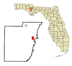
Blountstown is a city and the county seat of Calhoun County, Florida, United States. [6] As of the 2020 census, the city had a population of 2,266.
Blountstown is named for John Blount, a Creek Indian [7] chief who served as a guide for General Andrew Jackson during his invasion of Spanish Florida in 1818. This invasion was not directed at Spain, per se, but at Seminoles who would attack settlements north of Florida, then retreat to relative safety below the border of Spanish Florida. Also, Spain did not return escaped slaves to the U.S. In any case, this invasion caused Spain to sell Florida to the United States, since it was apparent that Spain would have a hard time defending against invasion. Thus, this territory became a part of the U.S. in 1821. [8] The city was officially incorporated in 1903. [2]
Blountstown was originally named for a Native American man, Chief (John Blount), who had been awarded land in the vicinity by Andrew Jackson for aiding Jackson in his battles against the Native Americans. However, he was forced to move from Florida to Texas in the 1830s. He died soon after being relocated. [9] However the current city started to be permanently settled by non-indigenous people around the 1820s. [1]
In the late 1850s, there was an open and violent feud between two rival factions which included the local Durden family. At one point, the Durdens and their rivals had a "pitched battle" at the courthouse square in Blountstown. [10]
On October 10, 2018, Blountstown was nearly annihilated when Category 5 Hurricane Michael struck the town. [11] The city was without power for almost three weeks and over 80% of homes and businesses were heavily damaged or destroyed. Blountstown High School suffered heavy damage, but Blountstown Elementary School was completely destroyed. In addition, the local timber and farming industries, which are Calhoun County's largest industries, were completely destroyed, costing millions of dollars in economic loss. [12]
The approximate coordinates for the City of Blountstown is located in east central Calhoun County at 30°26′35″N85°02′43″W / 30.442957°N 85.045402°W . [13]
According to the United States Census Bureau, the city has a total area of 3.2 square miles (8.3 km2), of which 3.2 square miles (8.3 km2) is land and 0.31% is water.
Directly to the east lies Bristol in Liberty County. Blountstown and Calhoun County uses the Central Time Zone, as opposed to Liberty County which is in the Eastern Time Zone.
The climate in this area is characterized by hot, humid summers and generally mild winters. According to the Köppen climate classification, the City of Blountstown has a humid subtropical climate zone (Cfa).
Census | Pop. | Note | %± |
---|---|---|---|
1910 | 546 | — | |
1920 | 863 | 58.1% | |
1930 | 1,270 | 47.2% | |
1940 | 1,931 | 52.0% | |
1950 | 2,118 | 9.7% | |
1960 | 2,375 | 12.1% | |
1970 | 2,384 | 0.4% | |
1980 | 2,632 | 10.4% | |
1990 | 2,404 | −8.7% | |
2000 | 2,444 | 1.7% | |
2010 | 2,514 | 2.9% | |
2020 | 2,266 | −9.9% | |
U.S. Decennial Census [14] |
Race | Pop 2010 [15] | Pop 2020 [16] | % 2010 | % 2020 |
---|---|---|---|---|
White (NH) | 1,667 | 1,439 | 66.31% | 63.50% |
Black or African American (NH) | 698 | 539 | 27.76% | 23.79% |
Native American or Alaska Native (NH) | 21 | 16 | 0.84% | 0.71% |
Asian (NH) | 10 | 9 | 0.40% | 0.40% |
Pacific Islander or Native Hawaiian (NH) | 2 | 0 | 0.08% | 0.00% |
Some other race (NH) | 0 | 0 | 0.00% | 0.00% |
Two or more races/Multiracial (NH) | 46 | 153 | 1.83% | 6.75% |
Hispanic or Latino (any race) | 70 | 110 | 2.78% | 4.85% |
Total | 2,514 | 2,266 | 100.00% | 100.00% |
As of the 2020 United States census, there were 2,266 people, 1,149 households, and 647 families residing in the city. [17]
In 2020, there was a 47.0% employment rate and a median household income of $37,083. 28.6% of the population lived below the poverty threshold. The median age in the city was 38.0 years old. [18]
As of the 2010 United States census, there were 2,514 people, 968 households, and 610 families residing in the city. [19]
As of the census [4] of 2000, there were 2,444 people, 913 households, and 595 families residing in the city. The population density was 767.2 inhabitants per square mile (296.2/km2). There were 1,046 housing units at an average density of 328.4 units per square mile (126.8 units/km2). The racial makeup of the city was 65.18% White, 31.79% African American, 1.27% Native American, 0.33% Asian, 0.08% Pacific Islander, 0.29% from other races, and 1.06% from two or more races. Hispanic or Latino of any race were 0.70% of the population.
In 2000, there were 913 households, out of which 27.4% had children under the age of 18 living with them, 40.6% were married couples living together, 21.6% had a female householder with no husband present, and 34.8% were non-families. 31.8% of all households were made up of individuals, and 17.9% had someone living alone who was 65 years of age or older. The average household size was 2.39 and the average family size was 2.99.
In 2000, in the city, the population was spread out, with 23.2% under the age of 18, 8.1% from 18 to 24, 22.1% from 25 to 44, 21.3% from 45 to 64, and 25.3% who were 65 years of age or older. The median age was 42 years. For every 100 females, there were 75.7 males. For every 100 females age 18 and over, there were 71.8 males.
In 2000, the median income for a household in the city was $23,271, and the median income for a family was $30,880. Males had a median income of $23,313 versus $20,000 for females. The per capita income for the city was $11,498. About 18.5% of families and 24.3% of the population were below the poverty line, including 33.6% of those under age 18 and 17.7% of those age 65 or over.
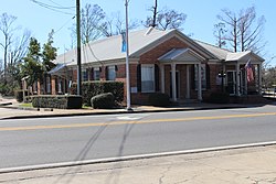
The old Calhoun County courthouse was located in Blountstown and is currently listed as a historic Florida landmark. [20]
The city is home of the Calhoun Correctional Institution.
Calhoun County School District operates public schools.
There are three schools located within the city:
Calhoun County is a county located in the U.S. state of Florida. As of the 2020 census, the population was 13,648, making it the fifth-least populous county in Florida. Its county seat is Blountstown.
Duval County is a county in the northeastern part of the U.S. state of Florida. As of July 2022, the population was 1,016,536, up from 864,263 in 2010. It is Florida's sixth-most populous county. Its county seat is Jacksonville, with which the Duval County government has been consolidated since 1968. Duval County was established in 1822, and is named for William Pope Duval, Governor of Florida Territory from 1822 to 1834. Duval County is the central county of the Jacksonville, Florida Metropolitan Statistical Area.
Gulf County is a county located in the panhandle of the U.S. state of Florida. As of the 2020 census, the population was 14,192. Its county seat is Port St. Joe.
Blount County is a county located in the U.S. state of Alabama. As of the 2020 census, the population was 59,134. Its county seat is Oneonta.
Calhoun County is a county in the east central part of the U.S. state of Alabama. As of the 2020 census, the population was 116,441. Its county seat is Anniston. It is named in honor of John C. Calhoun, a US Senator from South Carolina who was a staunch supporter of slavery.
Cherokee County, Alabama is a county located in the northeastern part of the U.S. state of Alabama. As of the 2020 census, the population was 24,971. Its county seat is Centre. The county is named for the Cherokee tribe.
Etowah County is a county located in the northeastern part of the U.S. state of Alabama. As of the 2020 census the population was 103,436. Its county seat is Gadsden. Its name is from a Cherokee word meaning "edible tree". In total area, it is the smallest county in Alabama, albeit one of the most densely populated. Etowah County comprises the Gadsden Metropolitan Statistical Area.
Cleburne County is a county located in the east central portion of the U.S. state of Alabama. As of the 2020 census, the population was 15,056. Its county seat is Heflin. Its name is in honor of Patrick R. Cleburne of Arkansas who rose to the rank of major general in the Confederate States Army. The eastern side of the county borders the state of Georgia.
Matagorda County is a county located in the U.S. state of Texas. As of the 2020 census, the population was 36,255. Its county seat is Bay City, not to be confused with the larger Baytown in Harris and Chambers Counties. Matagorda County is named for the canebrakes that once grew along the coast.
Harrell is a town in Calhoun County, Arkansas, United States. The population was 254 at the 2010 census. It is part of the Camden Micropolitan Statistical Area.
Archer is a city in Alachua County, Florida, United States. It is part of the Gainesville, Florida Metropolitan Statistical Area. As of the 2020 census, the city had a population of 1,140, up from 1,118 at the 2010 census.
Wewahitchka is a city in Gulf County, Florida, United States. The population was 2,074 as of the 2020 census. From the creation of Gulf County in 1925 until 1965, it served as the county seat before the county seat was moved to Port St. Joe. The City of Wewahitchka was settled around 1870 and officially founded in 1875. The city took its name from a Native American word meaning "water eyes". Two lakes along the edge of town look like a perfect pair of eyes, one of the lakes is called Lake Julia, while the other one is Lake Alice.
Mascotte is a city in Lake County, Florida, United States. As of the 2020 census, the population was 6,609, up from 5,101 in 2010. It is part of the Orlando–Kissimmee–Sanford Metropolitan Statistical Area.
Bristol is a city in and the county seat of Liberty County, Florida, United States. It is the only incorporated city in Liberty County. The population was 918 at the 2020 census.
Madison is a city in and the county seat of Madison County, on the central northern border of Florida, United States. The population was 2,912 at the 2020 census.
Leisure City is an unincorporated community and census-designated place (CDP) in Miami-Dade County, Florida, United States, that includes the smaller, older community of Modello in its northwestern section. The CDP is most notable for the Coral Castle Museum, located in the Modello area. It is located in the Miami metropolitan area of South Florida. The population was 26,324 at the 2020 census, up from 22,655 in 2010.
Layton is a city located on the island of Long Key in Monroe County, Florida, United States. The city is part of the Florida Keys. The population was 210 at the 2020 census.
Ebro is a town in Washington County, Florida, United States. The town is part of the Florida Panhandle, and located in North Florida. As of 2020, the population recorded by the U.S. Census Bureau is 237, down from 270 at the 2010 census. It is part of the Panama City—Panama City Beach, Florida Metropolitan Statistical Area.
Fort Calhoun is a city in Washington County, Nebraska, United States. The population was 1,108 at the 2020 census. The city includes Fort Atkinson, the first fort built west of the Missouri River.
St. Clair County is a county located in the central portion of the U.S. state of Alabama. As of the 2020 census, the population was 91,103. It has two county seats: Ashville and Pell City. It is one of two counties in Alabama, and one of 33 in the United States, with more than one county seat. Its name is in honor of General Arthur St. Clair, an officer in the French and Indian War. St. Clair County is included in the Birmingham, Alabama Metropolitan Statistical Area.