Bruceville-Eddy, Texas | |
---|---|
Coordinates: 31°18′20″N97°15′13″W / 31.30556°N 97.25361°W | |
Country | United States |
State | Texas |
Counties | McLennan, Falls |
Government | |
• Type | Mayor-Council |
Area | |
• Total | 4.12 sq mi (10.67 km2) |
• Land | 4.11 sq mi (10.65 km2) |
• Water | 0.01 sq mi (0.02 km2) |
Elevation | 686 ft (209 m) |
Population (2020) | |
• Total | 1,413 |
• Density | 412.79/sq mi (159.36/km2) |
Time zone | UTC-6 (Central (CST)) |
• Summer (DST) | UTC-5 (CDT) |
ZIP code | 76630 (Bruceville), 76524 (Eddy) |
Area code | 254 |
FIPS code | 48-10828 [3] |
GNIS feature ID | 1385216 [2] |
Website | bruceville-eddy |
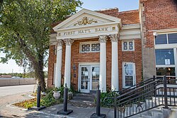
Bruceville-Eddy is a city in McLennan and Falls counties in the U.S. state of Texas. Its population was 1,413 at the 2020 census. [4]
Most of the city is in McLennan County and is part of the Waco metropolitan statistical area. A small southern portion is in Falls County.
Bruceville-Eddy is located in southwestern McLennan County and is situated along Interstate 35, 18 miles (29 km) south of Waco and 16 miles (26 km) north of Temple. [5] Access is available from Exit 315 (the Eddy or southern end of town) and Exit 318 (the Bruceville or northern end). Texas State Highway 7 leads east from Exit 315 22 miles (35 km) to Marlin.
According to the United States Census Bureau, the city has a total area of 3.2 square miles (8.3 km2), all land. [4]
The community of Bruceville-Eddy began as two separate settlements: Bruceville and Eddy. Both communities became stations on the Missouri–Kansas–Texas Railroad (Katy Railroad) in 1882. [6]
Bruceville was named for Lucien N. Bruce, who donated land for the railroad station. Most of Bruceville's residents came from the community of Mastersville, located two miles to the north, that the railroad had bypassed. By 1900, Bruceville had approximately 289 residents and several businesses. An independent school district was formed in 1904. A bank operated in Bruceville from 1907 to 1927. The community had a population around 500 during the 1930s and 1940s, but began to decline in the postwar years. By 1964, the number of inhabitants had fallen to 175 and decreased to just 25 in 1970. [5] [6]
Initially known as "Marvin", the community was renamed after the railroad arrived in 1882, to honor rail division superintendent Everett B. Eddy. By the mid-1880s, the community was home to 150 people, three general stores, two churches, a school, and a gristmill. Throughout the 1890s, Eddy continued to experience rapid growth, with some estimates placing the total population as high as 700. A bank opened in 1901 and received a national charter in 1915. In 1928, the schools in Bruceville and Eddy were consolidated, the first such merger in McLennan County. By the late 1920s, Eddy had roughly 450 residents. The population declined to 350 by the mid-1940s, but rose to around 600 in the 1960s as road improvements made commuting easier for locals. [5] [6]
In April 1974, the communities of Bruceville and Eddy incorporated as a single entity known as Bruceville-Eddy. [7] The population stood at 1,038 in 1980 and grew slightly to 1,075 by 1990. That figure rose further, to 1,490, by 2000.
Owing to its unique history, Bruceville-Eddy operated two separate post offices after it was incorporated. Eddy's post office, located at 100 Franklin Road, operates under the ZIP code 76524. [8] The post office in Bruceville was located at 203 First Street and had the ZIP code 76630. [9] On June 1, 2009, it was closed due to foundation problems that caused the building to be deemed unsafe. All postal operations were transferred to Eddy. [10]
Census | Pop. | Note | %± |
---|---|---|---|
1980 | 1,038 | — | |
1990 | 1,075 | 3.6% | |
2000 | 1,490 | 38.6% | |
2010 | 1,475 | −1.0% | |
2020 | 1,413 | −4.2% | |
U.S. Decennial Census [11] |
Race | Number | Percentage |
---|---|---|
White (NH) | 1,041 | 73.67% |
Black or African American (NH) | 27 | 1.91% |
Native American or Alaska Native (NH) | 3 | 0.21% |
Asian (NH) | 11 | 0.78% |
Some Other Race (NH) | 3 | 0.21% |
Mixed/Multi-Racial (NH) | 84 | 5.94% |
Hispanic or Latino | 244 | 17.27% |
Total | 1,413 |
As of the 2020 United States census, there were 1,413 people, 604 households, and 412 families residing in the city.
As of the census [3] of 2000, 1,490 people, 543 households, and 432 families were residing in the city. The population density was 460.8 people/sq mi (178.1/km2). The 587 housing units averaged 181.5/sq mi (70.2/km2). The racial makeup of the city was 89.73% White, 0.81% African American, 0.67% Native American, 0.07% Asian, 6.51% from other races, and 2.21% from two or more races. Hispanics or Latinos of any race were 10.34% of the population.
Of the 543 households, 37.2% had children under 18 living with them, 65.0% were married couples living together, 9.0% had a female householder with no husband present, and 20.4% were not families. About 18.2% of all households were made up of individuals, and 9.2% had someone living alone who was 65 or older. The average household size was 2.74, and the average family size was 3.10.
The city's age distribution was 29.7% under 18, 5.9% from 18 to 24, 30.3% from 25 to 44, 21.7% from 45 to 64, and 12.3% who were 65 or older. The median age was 35 years. For every 100 females, there were 94.3 males. For every 100 females age 18 and over, there were 96.6 males.
The median household income was $36,089, and the median family income was $39,766. Males had a median income of $30,139 versus $19,125 for females. The per capita income for the city was $15,642. About 9.4% of families and 11.8% of the population were below the poverty line, including 16.8% of those under age 18 and 9.9% of those age 65 or over.
The city of Bruceville-Eddy is served by the Bruceville-Eddy Independent School District.
McLennan County is a county located on the Edwards Plateau in Central Texas. As of the 2020 census, its population was 260,579. Its county seat and largest city is Waco. The U.S. census 2023 county population estimate is 268,583. The county is named for Neil McLennan, an early Scottish settler who worked to evict the Native Americans in frontier Texas. McLennan County is included in the Waco Metropolitan Statistical Area.
Murray County is a county located in the northwestern part of the U.S. state of Georgia. As of the 2020 census, the population was 39,973. The county seat is Chatsworth.
McFarland is a city in Wabaunsee County, Kansas, United States. As of the 2020 census, the population of the city was 272.
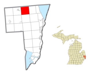
Greenwood Township is a civil township of St. Clair County in the U.S. state of Michigan. The population was 1,490 at the 2020 Census.
Edgar is a city in Clay County, Nebraska, United States. The population was 498 at the 2010 census. It is part of the Hastings, Nebraska Micropolitan Statistical Area.
Olmos Park is a city in Bexar County, Texas, United States. The population was 2,180 at the 2020 census. The town is noted for its park-like setting, oak-tree lined streets, and large estates, many of which were constructed during the 1920s. The town is four miles north of downtown San Antonio and is surrounded by the city of San Antonio on the west, north, and south side.
Rusk is a city and the county seat of Cherokee County in the U.S. state of Texas. At the 2020 United States census, it had a population of 5,285.
Fabens is a census-designated place (CDP) in El Paso County, Texas, United States. The population was 8,257 at the 2010 census. It is part of the El Paso Metropolitan Statistical Area. The ZIP Codes encompassing the CDP area are 79836 and 79838.
Channelview is a census-designated place (CDP) in the U.S. state of Texas on the east side of Houston in Harris County. Its population was 45,688 at the 2020 U.S. census.
Hilshire Village is a city in Harris County, Texas, United States. The population was 816 at the 2020 census. The city is the smallest of the Memorial Villages in terms of area.
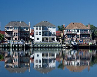
Nassau Bay is a city in Harris County, Texas, United States, bordering the outermost southeastern edge of the city of Houston. It is located in the Clear Lake Area near Galveston Bay, directly adjacent to the Lyndon B. Johnson Space Center. The population was 5,347 at the 2020 census.
Sheldon is an unincorporated community and a census-designated place (CDP) in northeastern Harris County, Texas, United States, located completely inside the extraterritorial jurisdiction of the City of Houston. The Sheldon area is located along Beltway 8 and US Highway 90, approximately twelve miles (19 km) northeast of Downtown Houston.
Taylor Lake Village is a city in Harris County, Texas, United States. The population was 3,704 at the 2020 U.S. census.
Robinson is a city in McLennan County, Texas, United States. The population was 12,443 at the 2020 census. It is part of the Waco Metropolitan Statistical Area.
West is a city in McLennan County, Texas, United States. As of the 2020 census, the city population was 2,531. It is named after Thomas West, the first postmaster of the city. The city is located in the north-central part of Texas, approximately 70 miles (110 km) south of the Dallas-Fort Worth Metroplex, 20 miles north of Waco and 120 miles north of Austin, the state's capital.
Altoona is a city in Eau Claire County, Wisconsin, United States. The population was 8,292 at the 2020 census with an estimated population in 2022 of 9,149. The city is a railroad terminal on the Union Pacific Railroad.
Valley Mills is a city in Bosque and McLennan counties in central Texas, United States. The population was 1,229 at the 2020 census.
Golinda is a city in Falls and McLennan counties in the U.S. state of Texas. The population was 618 at the 2020 census, an increase over the figure of 559 tabulated in 2010.
Bendena is a census-designated place (CDP) in Doniphan County, Kansas, United States. As of the 2020 census, the population was 117. The community is part of the St. Joseph, MO–KS Metropolitan Statistical Area.
Milton is a census-designated place (CDP) in Sumner County, Kansas, United States. As of the 2020 census, the population was 155. It is located 4.5 miles (7.2 km) southeast of Norwich at the intersection of N Argonia Rd and W 120th Ave N, next to the railroad.