
McDowell County is a county located in the U.S. state of North Carolina. As of the 2020 census, the population was 44,578. Its county seat is Marion.

Bucks Lake is a census-designated place (CDP) in Plumas County, California, United States. Bucks Lake is located on the south shore of the lake of the same name, 13 miles (20.9 km) west-southwest of Quincy. The population was 22 at the 2020 census, up from 10 at the 2010 census.

Arietta is a town in Hamilton County, New York, United States. The population was 292 at the 2020 census. The town was named after the mother of one of the first settlers, Rensselaer Van Rennslaer.

Indian Lake is a town in Hamilton County, New York, United States. The population was 1,352 at the 2010 census. The name is from a lake of the same name that is largely inside the town. There are no permanent stop lights in the town. Law enforcement is provided by New York State Troopers and Hamilton County Sheriff's Office.
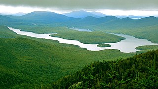
The body of water named Lake Placid is located in the Adirondack Mountains in northern New York, the United States. It is on the northern side of the Village of Lake Placid.

The Feather River is the principal tributary of the Sacramento River, in the Sacramento Valley of Northern California. The river's main stem is about 73 miles (117 km) long. Its length to its most distant headwater tributary is just over 210 miles (340 km). The main stem Feather River begins in Lake Oroville, where its four long tributary forks join—the South Fork, Middle Fork, North Fork, and West Branch Feather Rivers. These and other tributaries drain part of the northern Sierra Nevada, and the extreme southern Cascades, as well as a small portion of the Sacramento Valley. The total drainage basin is about 6,200 square miles (16,000 km2), with approximately 3,604 square miles (9,330 km2) above Lake Oroville.

Buck's Pocket State Park is a public recreation area located on Sand Mountain in the northeast corner of the U.S. state of Alabama, two miles (3.2 km) north of the community of Grove Oak. The state park occupies 2,000 acres (810 ha) surrounding a natural pocket (canyon) of the Appalachian Mountain chain along South Sauty Creek, an upstream tributary on the east side of Guntersville Lake. The park is known for the sweeping views of its rugged, seemingly untouched landscape provided from the heights of Point Rock.

Cranberry Lake is on the east branch of the Oswegatchie River in the Adirondack Park in New York in the United States. It is the third largest lake in the Adirondack Park. About 75 percent of the shoreline is owned by the State of New York. The 118,000-acre (480 km2) Five Ponds Wilderness Area abuts its south shore, and the Cranberry Lake Wild Forest covers much of its remaining shoreline.

Plumas National Forest is a 1,146,000-acre (4,640 km2) United States National Forest located at the northern terminus of the Sierra Nevada, in northern California. The Forest was named after its primary watershed, the Rio de las Plumas, or Feather River.

Kattskill Bay is a hamlet in the towns of Queensbury in Warren County and Fort Ann in Washington County in the state of New York, United States. The hamlet is located along the shore of Warner and Van Warmer Bays of Lake George. Kattskill Bay was part of the proposed East Lake George village. Pilot Knob Road is the major highway that runs through the hamlet. The hamlet is located at the base of Buck Mountain.
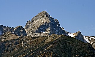
Buck Mountain is a mountain located in the Teton Range, Grand Teton National Park, Wyoming, immediately southeast of Grand Teton.

Static Peak is located in the Teton Range, Grand Teton National Park, in the U.S. state of Wyoming. Located .48 miles (0.77 km) southeast of Buck Mountain, the summit is also east of the Alaska Basin Trail, from a point known as Static Peak Divide, the summit can be climbed in a scramble. Below the summit on the north face, a small remnant glacier persists, sheltered from direct sunlight by steep cliffs. Timberline Lake lies to the north of the peak.
The Bucks Lake Wilderness is a 23,958-acre (97.0 km2) wilderness area located in the Plumas National Forest section of the Sierra Nevada, in northeastern California, United States.

The Madison Range is a mountain range located in the Rocky Mountains of Montana and Idaho in the United States. The range was named in honor of future President of the United States, then U.S. Secretary of State James Madison by Meriwether Lewis as the Lewis and Clark Expedition travelled through Montana in 1805. The range extends 80 miles (130 km) from West Yellowstone, Montana to Bozeman, Montana and is flanked by the Madison River on the west and the Gallatin River to the east. The highest point in the range is Hilgard Peak at 11,316 ft (3,449 m), a remote peak that wasn't climbed until 1948.

Haycock Mountain or known as Ghost Mountain is a locally prominent hill with the highest summit in Bucks County. It rises above Nockamixon State Park, in the Delaware River drainage of southeastern Pennsylvania. Early settlers named it simply for its "resemblance to a cock of hay."

Albert Hale Sylvester was a pioneer surveyor, explorer, and forest supervisor in the Cascade Range of the U.S. state of Washington. He was a topographer for the United States Geological Survey (USGS) in the Snoqualmie Ranger District between 1897 and 1907. Then, from 1908 to 1931, he served the United States Forest Service as the first forest supervisor of Wenatchee National Forest. His work involved the first detailed surveying and mapping of large portions of the Cascade Range in Washington, over the course of which he gave names to over 1,000 natural features. The surveying work often required placing cairns and other survey targets on top of mountains. He made the first ascents of a number of mountains in Washington. Over the course of his career he explored areas previously unknown to non-indigenous people. One such area, which Sylvester discovered, explored, and named, is The Enchantments. In 1944, while leading a party of friends to one of his favorite parts of the mountains, Sylvester was mortally wounded when his horse panicked and lost his footing on a steep and rocky slope.

Buck Mountain is a mountain in Columbia County and Luzerne County, Pennsylvania, in the United States. Its elevation is 1,942 feet (592 m) above sea level. The mountain contains deposits of coal. Shale and conglomerate are also present. The coal on the mountain was historically mined, altering the landscape somewhat. It is most likely named after Albert Ansbach.
Applebachsville is a populated place in Haycock Township, Bucks County, Pennsylvania, United States, located 2.6 miles (4.2 km) northeast of Richlandtown.

Buck Mountain is a mountain in the Adirondack Mountains region of New York. It is located in Long Lake, New York, southwest of Tupper Lake in Hamilton County. The Buck Mountain Fire Observation Station is located on top of the mountain. In 2023, a newly constructed 1.2-mile trail opened that provided public access to the long-restricted fire tower.

