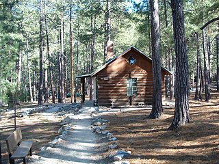
Scouting in Arizona has a history starting from the 1910s to the present day, serving youth in programs that suit the environment in which they live.
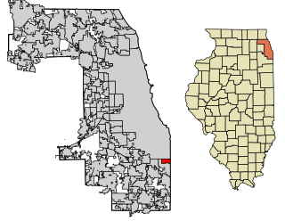
Burnham is a village in Cook County, Illinois, United States. The population was 4,046 at the 2020 census. Burnham has a Chicago ZIP code (60633) and was named for Telford Burnham, who drew its plat.

Riverside is a suburban village in Cook County, Illinois, United States. The population of the village was 9,298 at the 2020 census. It is a suburb of Chicago, located roughly 9 miles (14 km) west of downtown Chicago and 2 miles (3 km) outside city limits. A significant portion of the village is in the Riverside Landscape Architecture District, designated a National Historic Landmark in 1970.

Wells is a town in Hamilton County, New York, United States. The population was 674 at the 2010 census. The town is named after Joshua Wells, a land agent, who built the first mills in the area. It is in the Adirondack Park and on the eastern border of the county. It is northwest of Schenectady.
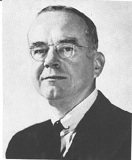
James Burnham was an American philosopher and political theorist. He chaired the New York University Department of Philosophy; his first book was An Introduction to Philosophical Analysis (1931). Burnham became a prominent Trotskyist activist in the 1930s. His most famous book, The Managerial Revolution (1941), speculated on the future of an increasingly proceduralist hence sclerotic society. A year before he wrote the book, he rejected Marxism and became an influential theorist of the political right as a leader of the American conservative movement. Burnham was an editor and a regular contributor to William F. Buckley's conservative magazine National Review on a variety of topics. He rejected containment of the Soviet Union and called for the rollback of communism worldwide.

The National Postal Museum, located in Washington, D.C., is the primary postal museum of the United States. It covers large portions of the postal history of the United States and other countries. It was established through joint agreement between the United States Postal Service and the Smithsonian Institution and opened in 1993.

The Illinois Railway Museum is the largest railroad museum in the United States. It is located in the Chicago metropolitan area at 7000 Olson Road in Union, Illinois, 55 miles (89 km) northwest of downtown Chicago.
The Clark Mountains are a group of low mountains rising above 1,200 metres (3,900 ft) located in the Ford Ranges, Marie Byrd Land, Antarctica. They are about 10 nautical miles east of the Allegheny Mountains.
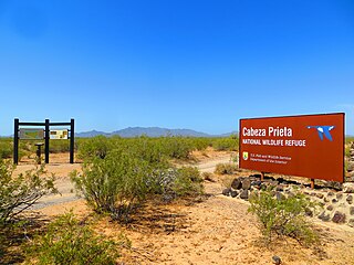
Cabeza Prieta National Wildlife Refuge (CPNWR) is located in southwestern Arizona in the United States, along 56 miles (90 km) of the Mexico–United States border. It is bordered to the north and to the west by the Barry M. Goldwater Air Force Range, to the south by Mexico's El Pinacate y Gran Desierto de Altar Biosphere Reserve, to the northeast by the town of Ajo, and to the southeast by Organ Pipe Cactus National Monument.
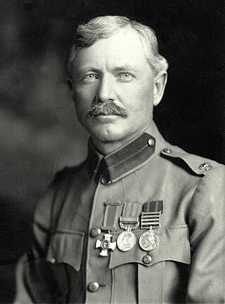
Major Frederick Russell Burnham DSO was an American scout and world-traveling adventurer. He is known for his service to the British South Africa Company and to the British Army in colonial Africa, and for teaching woodcraft to Robert Baden-Powell in Rhodesia. Burnham helped inspire the founding of the international Scouting Movement.

Russell Adam Burnham, is an American business owner, Physician Assistant and U.S. Army veteran. Burnham was recognized as the 2003 U.S. Army Soldier of the Year, 2007 U.S. Army Medical Corps NCO of the Year, and is an Eagle Scout. He is the great-grandson of Frederick Russell Burnham (1861–1947), recipient of the Distinguished Service Order, and famous American scout and world-traveling adventurer who helped inspire the founding of the international Scouting Movement.

The Cordillera Darwin is an extensive mountain range mantled by an ice field that is located in Chile.

Mount Burnham is one of the highest peaks in the San Gabriel Mountains. It is in the Sheep Mountain Wilderness. It is named for Frederick Russell Burnham the famous American military scout who taught Scoutcraft to Robert Baden-Powell and became one of the inspirations for the founding of the Boy Scouts. Mount Burnham was officially recognized by the USGS at a dedication ceremony in 1951. It was original known as "North Baldy Mountain". The peak is within Los Angeles County, about 16 miles (26 km) north of Glendora, and 66 miles (106 km) from Los Angeles. In 1956, Mount Burnham was added to the list of Signature Summits by the Hundred Peaks Section of the Sierra Club.

The Wild Oak Trail is a 27.0-mile (43.5 km) National Recreation Trail located in the Ridge-and-Valley Appalachians in Central Virginia, United States. It is part of George Washington National Forest. The trail is a loop, and begins at the headwaters of the North River, and traverses up to several ridge tops. Due to the trail's difficulty and length, it sees little traffic.

The Kofa National Wildlife Refuge is located in Arizona in the southwestern United States, northeast of Yuma and southeast of Quartzsite. The refuge, established in 1939 to protect desert bighorn sheep, encompasses over 665,400 acres (2,693 km2) of the Yuma Desert region of the Sonoran Desert. Broad, gently sloping foothills as well as the sharp, needlepoint peaks of the Kofa Mountains are found in the rugged refuge. The small, widely scattered waterholes attract a surprising number of water birds for a desert area. A wide variety of plant life is also found throughout the refuge. Kofa Wilderness takes up 547,719 acres of the refuge, making it the second largest wilderness area in Arizona.

Paradise Cay, also known as County Service Area No. 29, is an unincorporated enclave, surrounded by the town of Tiburon in Marin County, California, United States, located 2 miles (3 km) south of Point San Quentin at an elevation of 23 feet. The waterfront community lies at the foot of the Tiburon Peninsula south of Corte Madera Creek along the San Francisco Bay. The community is in ZIP code 94920 and area code 415.
The Bodie Hills is a low mountain range in Mono County, California, in the United States. The highest peak is Potato Peak at an altitude of 10,220 ft (3,115 m). The Bodie Hills are between Bridgeport and the Nevada border, where they become the Bodie Mountains in Mineral County, Nevada. The Sierra Nevada lies to the west. The mining district and town of Bodie, California, is located in the Bodie Hills.

The natural environment of Virginia encompasses the physical geography and biology of the U.S. state of Virginia. Virginia has a total area of 42,774.2 square miles (110,784.67 km2), including 3,180.13 square miles (8,236.5 km2) of water, making it the 35th-largest state by area. Forests cover 65% of the state, wetlands and water cover 6% of the land in the state, while 5% of the state is a mixture of commercial, residential, and transitional.

The Mountain states form one of the nine geographic divisions of the United States that are officially recognized by the United States Census Bureau. It is a subregion of the Western United States.

The Laurel Fork is a 15.7-mile-long (25.3 km) stream in Virginia and West Virginia, United States. The stream flows north from Highland County, Virginia, where its source and the majority of its length is located, to its mouth in Pendleton County, West Virginia. Laurel Fork is a tributary to the North Fork South Branch Potomac River, making it a part of the Potomac River watershed. The area surrounding Laurel Fork is home to several plant and animal species found nowhere else in Virginia, and is a prime example of a northern boreal forest in the state.

