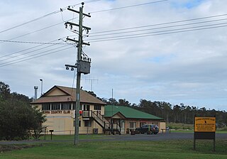
Canina is a locality in the Gympie Region, Queensland, Australia. [1]
Canina is a locality in the Gympie Region, Queensland, Australia. [1]
Tin Can Bay Road (State Route 15) enters the locality from the south-west. Kin Kin Road splits from Tin Can Bay Road at Canina and proceeds east ultimately to Kin Kin, while Tin Can Bay Road continues, without a route number, to the north ultimately to Tin Can Bay. [2]

Gympie is a town and a locality in the Gympie Region, Queensland, Australia. Located in the Wide Bay-Burnett district, Gympie is about 160 kilometres (100 mi) north of the state capital, Brisbane. The city lies on the Mary River, which floods the town periodically. Gympie is the administrative centre for the Gympie Region area. As at June 2018 Gympie had a population of 21,599.

Rainbow Beach is a coastal rural town and locality in the Gympie Region, Queensland, Australia. In the 2016 census, Rainbow Beach had a population of 1,249 people.

Cooloola is a coastal locality in the Gympie Region, Queensland, Australia. In the 2016 census, Cooloola had a population of 3 people.

Tin Can Bay is a coastal town and locality in the Wide Bay–Burnett region in Queensland, Australia. The locality is split between the Fraser Coast Region and the Gympie Region, but the town itself is within Gympie Region. In the 2016 census, Tin Can Bay had a population of 2,242 people.

Gympie Road is a major road in the northern suburbs of Brisbane, Queensland, Australia. The road forms part of the main road route from the Brisbane Central Business District (CBD) to the northern suburbs, Sunshine Coast and east coast of Queensland.

Victory Heights is a locality in the Gympie Region, Queensland, Australia.
Monkland is a locality in the Gympie Region, Queensland, Australia.

Southside is a semi-rural locality in the Gympie Region, Queensland, Australia. In the 2016 census, Southside had a population of 5,737 people.

Dagun is a rural town and locality in the Gympie Region, Queensland, Australia. In the 2016 census, Dagun had a population of 150 people.

Curra is a locality in the Gympie Region, Queensland, Australia. At the 2016 census, Curra had a population of 1,920.

Miva is a locality split between the Gympie Region and the Fraser Coast Region in Queensland, Australia.

Toolara Forest is a locality split between Gympie Region and Fraser Coast Region, Queensland, Australia.

Bells Bridge is a locality in the Gympie Region, Queensland, Australia.

Wolvi is a rural locality in the Gympie Region, Queensland, Australia. In the 2016 census, Wolvi had a population of 467 people.

Calico Creek is a locality in the Gympie Region, Queensland, Australia.

Lagoon Pocket is a locality in the Gympie Region, Queensland, Australia.

Wilsons Pocket is a locality in the Gympie Region, Queensland, Australia.

Woondum is a locality in the Gympie Region, Queensland, Australia.

Black Snake is a locality in the Gympie Region, Queensland, Australia. In the 2016 census, Black Snake had a population of 75 people.

Inskip is a coastal locality in the Gympie Region, Queensland, Australia. In the 2016 census, Inskip had a population of 52 people. Inskip Point at the north of the locality is a vehicular gateway to Fraser Island.
| This Gympie Region, Queensland, Australia location article is a stub. You can help Wikipedia by expanding it. |