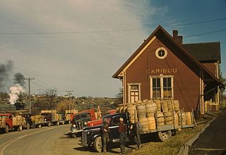
Caribou is the second largest city in Aroostook County, Maine, United States. Its population was 8,189 at the 2010 census. The city is a service center for the agricultural and tourism industries, and the location of a National Weather Service Forecast Office.

The Northumberland Strait is a strait in the southern part of the Gulf of Saint Lawrence in eastern Canada. The strait is formed by Prince Edward Island and the gulf's eastern, southern, and western shores.

Fundy National Park is a national park of Canada located on the Bay of Fundy, near the village of Alma, New Brunswick. It was officially opened on 29 July 1950. The Park showcases a rugged coastline which rises up to the Canadian Highlands, the highest tides in the world and more than 25 waterfalls. The Park covers an area of 207 km2 (80 sq mi) along Goose Bay, the northwestern branch of the Bay of Fundy. When one looks across the Bay, one can see the northern Nova Scotia coast.

Daniel Victor Snaith is a Canadian composer, musician, and recording artist who has performed under the stage names Caribou, Manitoba, and Daphni.

Cape Tormentine is a local service district in southeastern New Brunswick, Canada. It is located on the Northumberland Strait at the Abegweit Passage, the shortest crossing between Prince Edward Island and the mainland. It once flourished as a transportation hub between New Brunswick and Prince Edward Island but has been in decline since 1997 when the ferry service was closed due to the opening of the Confederation Bridge. At the Canada 2011 Census the population was 108, three quarters what it was at the 2006 census.

The Athabasca Basin is a region in the Canadian Shield of northern Saskatchewan and Alberta, Canada. It is best known as the world's leading source of high-grade uranium and currently supplies about 20% of the world's uranium.

Aroostook is a Canadian village in Victoria County, New Brunswick.
Caribou is one common name for the deer species Rangifer tarandus, also known as reindeer.
The 2007 Canada Winter Games were held in Whitehorse, Yukon, from Friday 23 February 2007 to Saturday 10 March 2007. These were the first Canada Games held North of 60. The games were held concurrent with the Inuit Games and Dene Games. The Games were televised by CBC, SRC, TSN, RDS, and APTN.

Brunswick tram depot is located on Sydney Road, Brunswick, a suburb of Melbourne, Australia. It opened on 26 April 1936 in conjunction with the electrification of the Brunswick and North Melbourne Cable tram line. Operated by Yarra Trams, it is one of eight tram depots on the Melbourne tram network.

State Route 161 (SR 161) is part of Maine's system of numbered state highways. It runs 86 miles (138 km) from Fort Fairfield to Allagash. It begins at the Fort Fairfield - Andover Border Crossing along the Canada–US border to Dickey Road near the confluence of the Allagash and Saint John rivers.

Tracy Depot is an unincorporated community in Restigouche County, New Brunswick, Canada.

The Caribou Mine is a copper-lead-zinc mine in the Bathurst Mining Camp of northern New Brunswick, Canada. It was discovered in 1955 and has seen several stages of development and production. The mine has changed ownership four times in the past 20 years.

McGivney is a settlement in New Brunswick, located 14.78 km SW of Boiestown, on the Canadian National Railway line, in Stanley Parish, York County.
Caribou Mine may refer to:

Caribou Air Force Station, also known as North River Depot and East Loring, is a defunct Air Force Station that operated from 1951 until its absorption into Loring Air Force Base in 1962. It was located in Limestone, Maine, adjacent to Loring. Between 1951 and 1962 Caribou was an Operational Storage Site for Air Materiel Command (AMC-OSS), one of five in the United States, and the weapons storage and maintenance facility for Loring alert aircraft.
The Southeast Upsalquitch River is an eastern tributary of the Upsalquitch River in the northwest of New Brunswick, Canada, flowing through Northumberland County and Balmoral Parish and Addington Parish in Restigouche County.
The Northwest Upsalquitch River is a tributary of the South bank of the Upsalquitch River, crossing the parishes of Saint-Quentin, Eldon and Addington, in Restigouche County, in the northwest of New Brunswick, in Canada.


