
Sierra County is a county located in the U.S. state of California. As of the 2020 census, the population was 3,236, making it California's second-least populous county. The county seat is Downieville; the sole incorporated city is Loyalton. The county is in the Sierra Nevada, northeast of Sacramento on the border with Nevada.
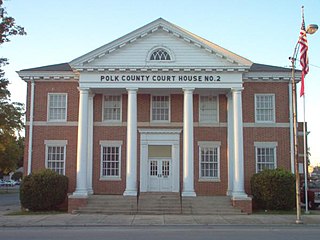
Polk County is a county in the Northwest region of the U.S. state of Georgia. As of the 2020 census, the population was 42,853. The county seat is Cedartown. The county was created on December 20, 1851, by an act of the Georgia General Assembly and named after James K. Polk, the eleventh President of the United States. Polk County comprises the Cedartown, GA Metropolitan Statistical Area.

Cherokee County is located in the US state of Georgia. As of the 2020 Census, the population was 266,620. The county seat is Canton. The county Board of Commissioners is the governing body, with members elected to office. Cherokee County is included in the Atlanta Metropolitan Area.

Carlton is a city in Yamhill County, Oregon, United States. The population was 2,135 as of the 2020 Census.

Carl Vinson was an American politician who served in the U.S. House of Representatives for over 50 years and was influential in the 20th century expansion of the U.S. Navy. He was a member of the Democratic Party and represented Georgia in the House from 1914 to 1965. He was known as "The Father of the Two-Ocean Navy". He is the longest-serving member of the United States House of Representatives from the state of Georgia. From 1961 to 1965, he served as the Dean of the US House of Representatives as the longest serving member of the body.
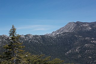
The San Jacinto Mountains are a mountain range in Riverside County, located east of Los Angeles in southern California in the United States. The mountains are named for one of the first Black Friars, Saint Hyacinth, who is a popular patron in Latin America.

Carl Dewey Perkins was an American politician and member of the United States House of Representatives from the Commonwealth of Kentucky serving from 1949 until his death from a heart attack in Lexington, Kentucky in 1984.

The Santa Catalina Mountains, commonly referred to as the Catalina Mountains or the Catalinas, are north and northeast of Tucson in Arizona, United States, on Tucson's north perimeter. The mountain range is the most prominent in the Tucson area, with the highest average elevation. The highest point in the Catalinas is Mount Lemmon at an elevation of 9,157 feet (2,791 m) above sea level and receives 18 inches (460 mm) of precipitation annually.

Pisgah National Forest is a National Forest in the Appalachian Mountains of western North Carolina. It is administered by the United States Forest Service, part of the United States Department of Agriculture. The Pisgah National Forest is completely contained within the state of North Carolina. The forest is managed together with the other three North Carolina National Forests from common headquarters in Asheville, North Carolina. There are local ranger district offices located in Pisgah Forest, Mars Hill, and Nebo.

Summit Lake Park is a park located along Mount Blue Sky Scenic Byway about 64 miles (100 km) west of Denver, Colorado. The park is 160 acres (0.65 km2) in size and contains alpine tundra. Land to the east of the lake is in a state of permafrost which helps to prevent drainage of the area. During the summer, the park is filled with wildflowers, some of which have not been found anywhere else outside of the Arctic Circle. The park is named after Summit Lake, the headwaters of Bear Creek.

Roxbury is an unincorporated community located off the Blue Mountain exit of the Pennsylvania Turnpike in Lurgan Township, Franklin County, Pennsylvania, United States. Route 641 and Route 997 meet there.
Lone Mountain State Forest is a state forest in Morgan County, Tennessee, located in the southeastern United States. The forest consists of 3,624 acres (14.67 km2) managed by the Tennessee Department of Agriculture.

Mount Schurz el. 11,007 feet (3,355 m) is a mountain peak in the Absaroka Range in Yellowstone National Park. Mount Schurz is the second highest peak in Yellowstone. The mountain was originally named Mount Doane by Henry D. Washburn during the Washburn–Langford–Doane Expedition in 1871. Later the name Mount Doane was given to another peak in the Absaroka Range by geologist Arnold Hague. In 1885, Hague named the mountain for the 13th U.S. Secretary of the Interior, Carl Schurz (1877–1881). Schurz was the first Secretary of the Interior to visit Yellowstone and a strong supporter of the national park movement.
Gray Mountain is an unincorporated community in Coconino County, Arizona, United States. Gray Mountain is located on U.S. Route 89, 39 miles (63 km) north-northeast of Flagstaff, and 10 miles (16 km) south-southwest of Cameron. It is assigned the ZIP code 86016.

The Mountain states form one of the nine geographic divisions of the United States that are officially recognized by the United States Census Bureau. It is a subregion of the Western United States.

Saylorsburg is a census-designated place and unincorporated community in Monroe County, Pennsylvania, United States. Saylorsburg is located off Pennsylvania Route 33, 5 miles (8.0 km) northwest of Wind Gap. As of the 2010 census, its population was 1,126. The village is located in both Ross Township and Hamilton Township.

Mount Blaurock is a high mountain summit of the Collegiate Peaks in the Sawatch Range of the Rocky Mountains of North America. The 13,623-foot (4,152 m) thirteener is located in San Isabel National Forest, 21.1 miles (33.9 km) northwest by west of the Town of Buena Vista in Chaffee County, Colorado, United States. Mount Blaurock was named in honor of Carl Blaurock, a co-founder of the Colorado Mountain Club and one of the first two persons to climb all of Colorado's fourteeners.
Richmond Mountain is a mountain located in the Catskill Mountains of New York east-northeast of Hunter. Richtmyer Peak is located northeast, Bump Mountain is located south, Steenburg Mountain is located north, and Ashland Pinnacle is located west-southwest of Richmond Mountain.
Bump Mountain is a mountain located in the Catskill Mountains of New York northeast of Ashland. Richtmyer Peak is located north-northeast, The Knob is located west, and Ashland Pinnacle is located west-southwest of Bump Mountain.

The 1888 United States presidential election in Colorado took place on November 6, 1888, as part of the 1888 United States presidential election. Voters chose three representatives, or electors to the Electoral College, who voted for president and vice president.

