
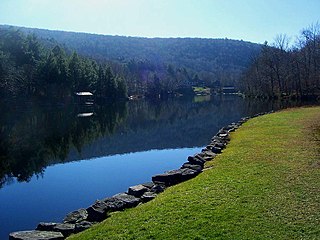
Indian Lake is a town in Hamilton County, New York, United States. The population was 1,352 at the 2010 census. The name is from a lake of the same name that is largely inside the town. There are no permanent stop lights in the town. Law enforcement is provided by New York State Troopers and Hamilton County Sheriff's Office.

Nokhu Crags is a rock formation and mountain summit in the Never Summer Mountains range of the Rocky Mountains of North America. The name is derived from the Arapaho language, Neaha-no-xhu, meaning "Eagles Nest." The 12,490-foot (3,807 m) peak is located in State Forest State Park, 2.5 miles (4.0 km) south of Cameron Pass in Jackson County, Colorado, United States. The summit lies just northwest of the Continental Divide and Rocky Mountain National Park, near the headwaters of the Michigan River. The peak is prominently visible from State Highway 14 and can be seen throughout the southern North Park basin where it is known also known as "Sawtooth Mountain", "the Crags" or "Sleeping Indian" for its resemblance to the form of a supine chief. To the east lie the shallow basins of Snow Lake and the Michigan or American Lakes; to the north lies a snow filled couloir; to the west the mountain descends directly into the deep waters of Lake Agnes; and to the south lie Static Peak, Mount Richthofen, and the remainder of the Never Summer Mountain Range.
Winnisook Lake is an artificial lake located in Oliverea, New York, United States. It is the source of Esopus Creek and the highest lake in the Catskill Mountains at 2,664 feet (812 m) above sea level.
Wild Basin a region in the southeast corner Rocky Mountain National Park in Colorado, United States. The primary entrance is located north of Allenspark off State Highway 7.
Indian Mountain State Park is a state park in Campbell County, Tennessee, in the southeastern United States. Established in 1971, the park consists of 213 acres (0.86 km2) situated at the base of Indian Mountain, a 1,949-foot (594 m) summit that overlooks the Elk Valley in the Cumberland Mountains. The park is located immediately west of the city of Jellico, and the history and development of the two are intertwined to a great extent.
Turtle Mountain Indian Reservation is a reservation located in northern North Dakota, United States. It is the land base for the Turtle Mountain Band of Chippewa Indians. The population of the Turtle Mountain Indian Reservation consists of Plains Ojibwe and Métis peoples; the reservation was established in 1882.

The Cedar River is a 38.5-mile-long (62.0 km) river in the central Adirondacks, in Hamilton County, New York. It rises at the outlet of Cedar Lake in the Town of Arietta and flows northeast into the Town of Lake Pleasant, where it passes through the Cedar River Flow. Continuing northeast and east, it passes through the Town of Indian Lake and remote corners of the Towns of Minerva and Newcomb to join the Hudson River northeast of the hamlet of Indian Lake. The Northville-Placid Trail goes past the Cedar Lakes and along the Cedar River to the flow.

Wallface Mountain is a mountain located in Essex County, New York, United States. The mountain is named after the cliff on its southeastern side. Wallface is flanked to the west by MacNaughton Mountain, and faces Mount Marshall to the southeast across Indian Pass.

Sunfish Pond is a 44-acre (18 ha) glacial lake surrounded by a 258-acre (104 ha) hardwood forest located on the Kittatinny Ridge within Worthington State Forest, adjacent to the Delaware Water Gap National Recreation Area in Warren County, New Jersey. The Appalachian Trail runs alongside the western and northern edges of the lake. It was created by the Wisconsin Glacier during the last ice age. The lake was declared a National Natural Landmark in January 1970.

Henderson Lake is located in the Adirondack Mountains in the town of Newcomb, Essex County, New York in the United States. It was named in 1826 after David Henderson, one of the founders of the Elba Iron Works near Lake Placid, New York, and of the Upper Works at Tahawus, New York. The lake is mainly cited by cartographers as the place where the Hudson River as named officially begins, flowing out of the eastern end and outlet of the lake. Unofficially, the source of the river is traced up Indian Pass Brook and other watercourses to Lake Tear of the Clouds.

The Albion Mountains are a mountain range in the U.S. states of Idaho (~99%) and Utah (~1%), spanning Cassia County, Idaho and barely reaching into Box Elder County, Utah. The highest point in the range is Cache Peak at 10,339 feet (3,151 m), and the range is a part of the Basin and Range Province. Most of the mountains are part of the Albion Division of the Minidoka Ranger District of Sawtooth National Forest.
Mount Independence is the second highest peak in the Albion Mountains of Idaho. The peak is located in Sawtooth National Forest and Cassia County. It is located about 1 mi (1.6 km) northwest of Cache Peak. The Independence Lakes are located in the basin to the east of the peak. Mount Independence supports one of the three populations of Cymopterus davisii, a plant that is endemic to the Albion Mountains. The Mount Independence population is considered a single population with Cache Peak. Mount Independence is 9,950 feet (3,030 m) above sea level.
Indian Mountain Lake is a census-designated place (CDP) in Carbon County and Monroe County, Pennsylvania. It is part of Northeastern Pennsylvania.

Vanderwhacker Mountain is a 3,389-foot-tall (1,033 m) mountain in the Adirondack Mountains region of New York. It is located northeast of Indian Lake and southeast of Newcomb in Essex County. The Vanderwhacker Mountain Fire Observation Station is located on top of the mountain. In May 1911, the Conservation Commission built a wooden fire observation tower on the mountain which was replaced in 1918, with a 35-foot-tall (11 m) metal tower. The tower stopped fire watching operations at the end of the 1988 season.

Rum Hill is a mountain located in Central New York Region of New York northwest of the Hamlet of Pierstown. Red House Hill is located southeast, Metcalf Hill is located south, Allen Lake and Mohegan Hill are located north-northwest and Otsego Lake is located east of Rum Hill.

Dun Brook Mountain is a mountain located in Adirondack Mountains of New York located in the town of Indian Lake east-northeast of Blue Mountain Lake. Tirrell Mountain is located west and Tirrel Pond is located west-southwest of Dun Brook Mountain.
Bell Mountain is a mountain located in Adirondack Mountains of New York located in the Town of Indian Lake east of Indian Lake.

Utsayantha Mountain is a 3,209-foot-tall (978 m) mountain in the Catskill Mountains of New York. It is located east-southeast of Stamford in Delaware County. Variant names include Utsayanthe Mountain, Utsayanthia Mountain, Utsayantho Mountain, and Utsyantha Mountain. McGregor Mountain is located southeast of Utsayantha Mountain and Churchill Mountain is located southwest. Utsayantha Mountain is named after Utsayantha, the daughter of Chief Ubiwacha, chief of the Lenape Indians.

Mount Garfield is a 13,074-foot-elevation (3,985-meter) mountain summit located in San Juan County, Colorado, United States. It is situated eight miles south of the community of Silverton, in the Weminuche Wilderness, on land managed by San Juan National Forest. It is part of the San Juan Mountains range which is a subset of the Rocky Mountains of North America. Precipitation runoff from the mountain drains into tributaries of the Animas River. The peak can be seen from U.S. Route 550 and the Durango and Silverton Narrow Gauge Railroad. Topographic relief is significant as the west aspect rises over 4,300 feet above the river and railway in approximately one mile. It is set six miles west of the Continental Divide, one mile west of Electric Peak, and three miles east-southeast of Snowdon Peak.

Electric Peak is a 13,292-foot-elevation (4,051-meter) mountain summit located in San Juan County, Colorado, United States. It is situated eight miles south of the community of Silverton, in the Weminuche Wilderness, on land managed by San Juan National Forest. It is part of the Needle Mountains which are a subset of the San Juan Mountains, which in turn is a subset of the Rocky Mountains. Precipitation runoff from the mountain drains into tributaries of the Animas River. The peak can be seen from U.S. Route 550 and the Durango and Silverton Narrow Gauge Railroad. Topographic relief is significant as the west aspect rises over 4,500 feet above the river and railway in approximately two miles. It is set five miles west of the Continental Divide, and one mile east of Mount Garfield. The mountain's name, which has been officially adopted by the United States Board on Geographic Names, was in use before 1906 when Henry Gannett published it in the Gazetteer of Colorado.

