Cherryfield, Maine

Last updated
Cherryfield, Maine
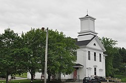
CherryfieldME Academy.jpg
Cherryfield Academy building, now housing town offices
USA Maine location map.svg
Red pog.svg
Cherryfield, Maine
Location within the state of Maine
Coordinates: 44°36′36″N67°55′46″W / 44.61000°N 67.92944°W / 44.61000; -67.92944
CountryUnited States
State Maine
County Washington
Area
[1]
  Total44.99 sq mi (116.52 km2)
  Land44.44 sq mi (115.10 km2)
  Water0.55 sq mi (1.42 km2)
Elevation
118 ft (36 m)
Population
 (2020)
  Total1,107
  Density25/sq mi (9.6/km2)
Time zone UTC-5 (Eastern (EST))
  Summer (DST) UTC-4 (EDT)
ZIP code
04622
Area code 207
FIPS code 23-12455
GNIS feature ID0582407

Cherryfield is a town in Washington County, Maine, United States on the Narraguagus River. It was named for the wild cherries that once peppered the banks of the river. [2] The town population was 1,107 at the 2020 census. [3] The town bills itself as the "Blueberry Capital of the World". Roughly 75 acres (300,000 m2) on both sides of the river are a historic district on the National Register of Historic Places known as the Cherryfield Historic District. This district comprises a collection of period structures dating from c.1750–1890. The town was first settled about 1760. In 1826,the part of Steuben known as Narraguagus was annexed onto Cherryfield.

Contents

Geography

According to the United States Census Bureau, the town has a total area of 44.99 square miles (116.52 km2), of which 44.44 square miles (115.10 km2) is land and 0.55 square miles (1.42 km2) is water. [1] The town is home to two breeding pairs of bald eagles. [4]

Demographics

Historical population
CensusPop.Note
1810 181
1820 24133.1%
1830 583141.9%
1840 1,00372.0%
1850 1,64864.3%
1860 1,7556.5%
1870 1,7600.3%
1880 1,7931.9%
1890 1,787−0.3%
1900 1,8594.0%
1910 1,499−19.4%
1920 1,304−13.0%
1930 1,112−14.7%
1940 1,046−5.9%
1950 904−13.6%
1960 780−13.7%
1970 771−1.2%
1980 98327.5%
1990 1,18320.3%
2000 1,157−2.2%
2010 1,2326.5%
2020 1,107−10.1%
U.S. Decennial Census [5]

2010 census

As of the census [6] of 2010, there were 1,232 people, 570 households, and 332 families living in the town. The population density was 27.7 inhabitants per square mile (10.7/km2). There were 743 housing units at an average density of 16.7 per square mile (6.4/km2). The racial makeup of the town was 96.2% White, 0.2% African American, 0.9% Native American, 0.4% Asian, 0.6% from other races, and 1.8% from two or more races. Hispanic or Latino of any race were 1.0% of the population.

There were 570 households, of which 22.6% had children under the age of 18 living with them, 40.5% were married couples living together, 10.7% had a female householder with no husband present, 7.0% had a male householder with no wife present, and 41.8% were non-families. 36.1% of all households were made up of individuals, and 19% had someone living alone who was 65 years of age or older. The average household size was 2.16 and the average family size was 2.73.

The median age in the town was 48.8 years. 19.2% of residents were under the age of 18; 4.5% were between the ages of 18 and 24; 20.7% were from 25 to 44; 32.1% were from 45 to 64; and 23.6% were 65 years of age or older. The gender makeup of the town was 47.4% male and 52.6% female.

2000 census

As of the census [7] of 2000, there were 1,157 people, 493 households, and 317 families living in the town. The population density was 26.5 inhabitants per square mile (10.2/km2). There were 644 housing units at an average density of 14.7 per square mile (5.7/km2). The racial makeup of the town was 98.01% White, 0.09% African American, 0.69% Native American, 0.43% Asian, 0.17% from other races, and 0.61% from two or more races. Hispanic or Latino of any race were 0.09% of the population.

There were 493 households, out of which 27.4% had children under the age of 18 living with them, 51.7% were married couples living together, 8.1% had a female householder with no husband present, and 35.5% were non-families. 30.6% of all households were made up of individuals, and 17.2% had someone living alone who was 65 years of age or older. The average household size was 2.29 and the average family size was 2.85.

In the town, the population was spread out, with 22.5% under the age of 18, 5.3% from 18 to 24, 24.0% from 25 to 44, 27.5% from 45 to 64, and 20.7% who were 65 years of age or older. The median age was 44 years. For every 100 females there were 87.2 males. For every 100 females age 18 and over, there were 88.1 males.

The median income for a household in the town was $21,486, and the median income for a family was $31,016. Males had a median income of $26,058 versus $20,000 for females. The per capita income for the town was $13,111. About 15.8% of families and 21.9% of the population were below the poverty line, including 24.6% of those under age 18 and 27.5% of those age 65 or over.
Notable people

Related Research Articles

<span class="mw-page-title-main">Washington County, Maine</span> County in Maine, United States

Washington County is a county located in the U.S. state of Maine. As of the 2020 census, its population was 31,095, making it the third-least populous county in Maine. Its county seat is Machias. The county was established on June 25, 1789. It borders the Canadian province of New Brunswick.

<span class="mw-page-title-main">Caswell, Maine</span> Town in the state of Maine, United States

Caswell is a town in Aroostook County, Maine, United States. The population was 293 at the 2020 census.

<span class="mw-page-title-main">Smyrna, Maine</span> Town in the state of Maine, United States

Smyrna is a town in Aroostook County, Maine, United States. The population was 439 at the 2020 census.

<span class="mw-page-title-main">Pownal, Maine</span> Town in Maine, United States

Pownal is a town in Cumberland County, Maine, United States. Pownal was included in the Lewiston-Auburn, Maine metropolitan New England city and town area. The population was 1,566 at the 2020 census. It is part of the Portland–South Portland–Biddeford, Maine Metropolitan Statistical Area. Pownal is home to Bradbury Mountain State Park.

<span class="mw-page-title-main">Benton, Maine</span> Town in the state of Maine, United States

Benton is a town in Kennebec County, Maine, United States. It was formed in 1842, as a subdivision of the town of Clinton. The population was 2,715 at the 2020 census. The town was named for Missouri Senator Thomas Hart Benton.

<span class="mw-page-title-main">Manchester, Maine</span> Town in Maine, United States

Manchester is a town in Kennebec County, Maine, United States, located at 44.33°N 69.87°W. The population was 2,456 at the 2020 census. The southern part of the town bordering Cobbosseecontee Lake is a popular recreation spot in central Maine, and part of the Winthrop Lakes Region. Manchester is included in the Augusta, Maine micropolitan and included in the Lewiston-Auburn, Maine metropolitan New England City and Town Area.

Stoneham is a town in Oxford County, Maine, United States. The population was 261 at the 2020 census.

<span class="mw-page-title-main">Stow, Maine</span> Town in the state of Maine, United States

Stow is a town in Oxford County, Maine, United States. The population was 393 at the 2020 census.

<span class="mw-page-title-main">Upton, Maine</span> Town in the state of Maine, United States

Upton is a town in Oxford County, Maine, United States. The population was 69 at the 2020 census.

Chester is a town in Penobscot County, Maine, United States. The population was 549 at the 2020 census.

<span class="mw-page-title-main">Clifton, Maine</span> Town in the state of Maine, United States

Clifton is a town in Penobscot County, Maine, United States. The population was 840 at the 2020 census. It is part of the Bangor Metropolitan Statistical Area.

Exeter is a town in Penobscot County, Maine, United States. The population was 963 at the 2020 census.

Kenduskeag is a town in Penobscot County, Maine, United States. The population was 1,346 at the 2020 census.

Passadumkeag is a town on the east bank of the Penobscot River at the confluence with the Passadumkeag River in Penobscot County, Maine, United States. The population was 356 at the 2020 census. Passadumkeag is a word of the Penobscot people meaning "quick water".

<span class="mw-page-title-main">Lake View Plantation, Maine</span> Plantation in Maine, United States

Lake View is a plantation in Piscataquis County, Maine, United States. The population was 150 at the 2020 census.

<span class="mw-page-title-main">Monroe, Maine</span> Town in the state of Maine, United States

Monroe is a town in Waldo County, Maine, United States named for President James Monroe. The population was 931 at the 2020 census.

Alexander is a town in Washington County, Maine, United States. The population was 525 at the 2020 census. The town is named for Alexander Baring, 1st Baron Ashburton, the British negotiator of the Webster–Ashburton Treaty which ended the Aroostook War in 1838–1839.

Beddington is a town in Washington County, Maine, United States. The population was 60 at the 2020 census. It is the third-smallest organized town in Maine after Frye Island and Frenchboro.

<span class="mw-page-title-main">Harrington, Maine</span> Town in the state of Maine, United States

Harrington is a town in Washington County, Maine, United States. The population was 962 at the 2020 census. Harrington is an old seafaring and shipbuilding village.

<span class="mw-page-title-main">Milbridge, Maine</span> Town in the state of Maine, United States

Milbridge is a town in Washington County, Maine, United States at the mouth of the Narraguagus River. The population was 1,375 at the 2020 census. The town was incorporated in 1848. It contains the villages of Milbridge and Wyman.

References

  1. 1 2 "US Gazetteer files 2010". United States Census Bureau . Retrieved 2012-12-16.
  2. "The Heart of Cherryfield - Down East Magazine - Maine". Archived from the original on 2009-01-06. Retrieved 2008-08-12.
  3. "Census - Geography Profile: Cherryfield town, Washington County, Maine". United States Census Bureau . Retrieved January 21, 2022.
  4. "Cherryfield Eagles".
  5. "Census of Population and Housing". Census.gov. Retrieved June 4, 2015.
  6. "U.S. Census website". United States Census Bureau . Retrieved 2012-12-16.
  7. "U.S. Census website". United States Census Bureau . Retrieved 2008-01-31.
  8. "150th Anniversary of the Epping Baseline | Cherryfield-Narraguagus Historical Society".
  9. "Epping Plains site of ambitious 1850s survey > Base line in Columbia one of 6 used to map eastern U.S."

Further reading

Varney, George J. (1886). "Gazetteer of the state of Maine. Cherryfield". Boston: Russell.{{cite journal}}: Cite journal requires |journal= (help)

44°36′26″N67°55′33″W / 44.60722°N 67.92583°W / 44.60722; -67.92583