
Ingavi is a province in the La Paz Department in Bolivia. This is where the Battle of Ingavi occurred on November 18, 1841 and where the World Heritage Site of Tiwanaku is situated.
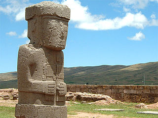
Tiwanaku Municipality is the third municipal section of the Ingavi Province in the La Paz Department, Bolivia. Its seat is the village of Tiwanaku located near the UNESCO World Heritage Site Tiwanaku.

Calacoto or Qala Qutu is the third municipal section of the Pacajes Province in the La Paz Department, Bolivia. Its seat is Calacoto.
The Jach'a Jawira is a river in the La Paz Department of Bolivia, south of Wiñaymarka, the southern branch of Lake Titicaca. It is a tributary of the Desaguadero River.

Kimsa Chata, also spelled Kimsachata, is a 4,735-metre-high (15,535 ft) mountain in the Andes in Bolivia. It is located in the Chilla-Kimsa Chata mountain range south-east of Wiñaymarka Lake, the southern part of Lake Titicaca. It lies in the La Paz Department, Ingavi Province, Tiwanaku Municipality, about 15 km south of the archaeological site of Tiwanaku and the village of the same name. Kimsa Chata is situated between the mountains Nasa Puqi in the north and Chuqi Ch'iwani in the south.

Kimsa Chata is a mountain in the Cordillera Real in the Andes of Bolivia, about 5,056 metres (16,588 ft) high. It is located in the La Paz Department, Los Andes Province, Batallas Municipality, Kirani Canton. It is situated south-west of the mountains Wila Lluxi, Warawarani and Phaq'u Kiwuta, between the mountain Qala T'uxu in the north and the lake Q'ara Quta in the south.
Qullqi Chata is a 4,876-metre-high (15,997 ft) mountain in the Cordillera Real in the Andes of Bolivia. It is situated in the La Paz Department, Los Andes Province, Batallas Municipality. Qullqi Chata lies south of the mountain Ch'iyar T'ikhi, west of Kimsa Chata and south-east of Taypi K'uchu. The river Jayllawaya, a tributary of Lake Titicaca, flows along its southern slope.
Wankarani is a mountain in the Andes of Bolivia, about 4,980 metres (16,339 ft) high. It lies in the Oruro Department, Sajama Province, in the north of the Turco Municipality. Wankarani is situated south-west of the Kimsa Chata group, north-east of the mountain Yaritani and south-east of the mountains Ch'iyar Jaqhi and Surani.
Imill Wawani is a 4,505-metre-high (14,780 ft) mountain in the Chilla-Kimsa Chata mountain range in the Andes of Bolivia. It is situated in the La Paz Department, Ingavi Province, Jesús de Machaca Municipality, north-east of Ch'ama (Chama). Imill Wawani lies south-west of the mountain Apachita and south-east of the mountain Jisk'a Sallalla.
Wisk'achani is a 4,585-metre-high (15,043 ft) mountain in the Chilla-Kimsa Chata mountain range in the Andes of Bolivia. It is situated in the La Paz Department, Ingavi Province, Jesús de Machaca Municipality, north-east of Ch'ama (Chama). Wisk'achani lies north of the mountain Imill Wawani, north-east of Jisk'a Sallalla and Sallalla and south-east of Q'ullq'uni. The river Wila Jaqhi Jahuira originates east of the mountain. It flows to the north-east.
Nasa Puqi is a 4,735-metre-high (15,535 ft) mountain in the Andes in Bolivia. It is located in the Chilla-Kimsa Chata mountain range south-east of Wiñaymarka Lake, the southern part of Lake Titicaca. It lies in the La Paz Department, Ingavi Province, Tiwanaku Municipality. Nasa Puqi is situated north of the mountains Chuqi Ch'iwani and Kimsa Chata.
Ch'utu Wankarani is a 4,475-metre-high (14,682 ft) mountain in the Chilla-Kimsa Chata mountain range in the Andes of Bolivia. It is located in the La Paz Department, Ingavi Province, Jesús de Machaca Municipality, northeast of Ch'ama (Chama). Ch'utu Wankarani lies northeast of Imill Wawani and Apachita and southeast of Jisk'a Sallalla and Wisk'achani. The Wila Jaqhi Jawira originates near Ch'utu Wankarani. It flows to the northeast.
Pukara is a 4,119-metre-high (13,514 ft) mountain in the Chilla-Kimsa Chata mountain range in the Andes of Bolivia. It is situated in the La Paz Department, Ingavi Province, Guaqui Municipality. The Chilla River flows along its western slope. It is a tributary of Wiñaymarka Lake, the southern branch of Lake Titicaca.
Chuqi Q'awa is a 4,790-metre-high (15,715 ft) mountain in the Chilla-Kimsa Chata mountain range in the Andes of Bolivia. It lies in the La Paz Department, Ingavi Province, Jesús de Machaca Municipality. Chuqi Q'awa is situated west of the mountain Pukara.
Chuqi Q'awa is a 4,570-metre-high (14,993 ft) mountain in the Chilla-Kimsa Chata mountain range in the Andes of Bolivia. It lies in the La Paz Department, Ingavi Province, in the north of the Jesús de Machaca Municipality, near the border with the Tiwanaku Municipality. Chuqi Q'awa is situated south of the river Chuñuni Jawira (Chununi Jahuira).
Qaluyu is a 4,202-metre-high (13,786 ft) mountain in the Chilla-Kimsa Chata mountain range in the Andes of Bolivia. It is located in the La Paz Department, Ingavi Province, Tiwanaku Municipality. Qaluyu is situated south-west of Pukara (Pucara) and south-east of the archaeological site of Tiwanaku. The village of Qaluyu (Caluyo) lies at its feet.
Ch'alla Qullu is a mountain in the Chilla-Kimsa Chata mountain range in the Andes of Bolivia which reaches a height of about 4,660 m (15,290 ft). It is located in the La Paz Department, Ingavi Province, Jesús de Machaca Municipality. Ch'alla Qullu lies northwest of Chhuxlla Willk'i. The Ch'uñu Jawira originates near the mountain. It flows to the south as a right affluent of the Jach'a Jawira.
Wila Qullu is a mountain in the Chilla-Kimsa Chata mountain range in the Andes of Bolivia which reaches a height of approximately 4,400 m (14,400 ft). It is located in the La Paz Department, Ingavi Province, on the border of the municipalities of Jesús de Machaca and Tiwanaku. Wila Qullu lies north of Chuqi Q'awa.
The Ch'alla Jawira is a river in the La Paz Department in Bolivia. It is a left tributary of the Tiwanaku River which empties into Wiñaymarka Lake, the southern part of Lake Titicaca.


