Settlement began circa 1820. The town of Clymer was established in 1821 from a division of the town of Chautauqua. In 1824, a division of Clymer was made to form the new town of Mina and again in 1829 to form the town of French Creek. In 1915, the population of Clymer was 1,341.
Neckers Co., a general store, has occupied the northwest corner of the main intersection in town since 1910, passing through four generations of the Neckers family.
On or about September 24, 2012, Clymer Central School superintendent Keith Reed Jr. was shot to death by an apparent murderer on his property near Clymer.[4]
This town is known for a Dutch heritage that's personified throughout with the placement of artificial windmills and other decorations.[according to whom?]
According to the United States Census Bureau, the town has a total area of 36.2 square miles (93.7km2), of which 36.1 square miles (93.4km2) is land and 0.08 square miles (0.2km2), or 0.26%, is water.[2]
As of the census[6] of 2000, there were 1,501 people, 502 households, and 400 families residing in the town. The population density was 41.6 inhabitants per square mile (16.1/km2). There were 550 housing units at an average density of 15.3 per square mile (5.9/km2). The racial makeup of the town was 99.13% White, 0.07% African American, 0.13% Native American, 0.27% Asian, 0.20% from other races, and 0.20% from two or more races. Hispanic or Latino of any race were 0.47% of the population.
There were 502 households, out of which 39.6% had children under the age of 18 living with them, 72.3% were married couples living together, 4.4% had a female householder with no husband present, and 20.3% were non-families. 17.5% of all households were made up of individuals, and 9.2% had someone living alone who was 65 years of age or older. The average household size was 2.99 and the average family size was 3.40.
In the town, the population was spread out, with 32.3% under the age of 18, 7.7% from 18 to 24, 27.6% from 25 to 44, 19.1% from 45 to 64, and 13.3% who were 65 years of age or older. The median age was 33 years. For every 100 females, there were 99.9 males. For every 100 females age 18 and over, there were 101.6 males.
The median income for a household in the town was $34,583, and the median income for a family was $38,654. Males had a median income of $30,000 versus $22,813 for females. The per capita income for the town was $13,710. 12.1% of the population and 9.0% of families were below the poverty line. Out of the total population, 17.3% of those under the age of 18 and 6.6% of those 65 and older were living below the poverty line.
Jehuu Caulcrick, former Michigan State fullback and NFL player; attended Clymer Central School
Communities and locations in Clymer
Clymer – The hamlet of Clymer is in the southwest corner of the town by the junction of State Route 474 and County Road 15. The Pennsylvania border lies 1.5 miles (2.4km) miles to the south and 6.75 miles (10.86km) to the west of the center of the hamlet.
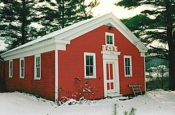
Clymer Center – A hamlet at the junction of County Road 10 and State Route 474 near the Little Red Schoolhouse in the middle of the town.
Clymer Hill – A hamlet in the northwest part of the town, west of Clymer Center.
Jaquins – A hamlet east of Clymer.
Kings Corners – A location at the junction of County Roads 10 and 23 at the eastern town line.
North Clymer – A hamlet at the junction of NY Route 474 and State Route 76 near the north town line. North Clymer was home to its own post office, ZIP code 14759, until May 24, 1997.
Wickwire Corners – A location formed by the intersection of Wickwire Road and State Route 474, east of North Clymer.
This page is based on this Wikipedia article Text is available under the CC BY-SA 4.0 license; additional terms may apply. Images, videos and audio are available under their respective licenses.