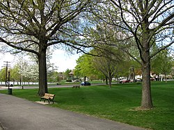
Wakefield is a town in Middlesex County, Massachusetts, United States, in the greater Boston metropolitan area, incorporated in 1812 and located about 12.5 mi (20.1 km) north-northwest of Downtown Boston. Wakefield's population was 27,090 at the 2020 census. Wakefield offers an assortment of activities around the local lake, Lake Quannapowitt.

The Old Douglas Center Historic District encompasses the historic heart of Douglas, Massachusetts. The historic district radiates away from the town common, and is bounded by farmlands and more recent 20th-century development. There are 50 contributing resources in the 192-acre (78 ha) district. Most of the structures are residential houses in Federal and Greek Revival styles. There are a number of institutional buildings, including the 1834 Greek Revival First Congregational Church, the Craftsman-style Douglas Pastime Club building at 22 Church Street, and the c. 1770s Dudley Tavern. The town common and the adjacent Center Cemetery, laid out when the town was incorporated in 1746, are at the center of the district.

The Gardner Uptown Historic District is a historic district encompassing the former civic heart of Gardner, Massachusetts. The 65-acre (26 ha) area includes the old town common, an early cemetery, and a modest number of non-residential buildings among a larger number of houses. The area was the center of civic life from the incorporation of Gardner in 1785 until municipal functions were moved to West Gardner beginning in the late 1920s. The district was listed on the National Register of Historic Places in 1999.

Phillipston Center Historic District encompasses the historic village center of Phillipston, Massachusetts. The town was first settled in 1751 on land grants made in the 1730s, and was incorporated as a separate town in the 1770s. The surviving village center not far from the location of the first settlement, eventually came to include a tavern. After incorporation, the center developed around what is now the junction of the Baldwinville, Petersham, and Templeton Roads, although this took time, possibly because of difficulties associated with the American Revolutionary War. As a result, the district has relatively few properties that date to the 18th century. All of these are modest vernacular residential structures. The town grew only modestly until 1830, after which time its population declined, not reaching the same level until 1980, 150 years later. As a result of the lack of growth, most of the properties in the district are Federal and Greek Revival in character. Many of the institutional buildings in the center date to the late 19th and early 20th centuries. The district was added to the National Register of Historic Places in 1999.

The Harvard Center Historic District is a historic district encompassing the traditional village center of Harvard, Massachusetts, USA. The district is centered on the town common, a triangular grassy space bounded by Elm Street, Still River Road, and Ayer Road. The common is ringed by residences, civic and religious buildings, and a small commercial area. The common was laid out when the town was founded in 1732, and has grown, mainly in periods of growth at the late 18th and late 19th/early 20th centuries. Most of the village's buildings post-date 1831. The district was added to the National Register of Historic Places in 1997.

The Shrewsbury Historic District encompasses the historic early center of the town of Shrewsbury, Massachusetts. It consists of the town common, laid out in 1721 at what are now Main and Prospect Streets, and buildings adjacent or nearby. The district was declared locally in 1972, and was added to the National Register of Historic Places in 1976.

Becket Center Historic District is a historic district encompassing the historic early center of Becket, Massachusetts. Centered at the junction of Massachusetts Route 8 and YMCA Road, this area was the town's civic heart and a center of industry until it was eclipsed in importance by North Becket, which was served by the railroad. Most of the architecture in the district is in the Federal and Greek Revival styles popular in the late 18th to mid 19th centuries. The district was added to the National Register of Historic Places in 1982.

The New Salem Common Historic District encompasses the historic town center of New Salem, Massachusetts. Located on South Main Street, it includes the town common and most of its civic and institutional buildings. Most buildings in the district date to the 18th and 19th centuries. The district was listed on the National Register of Historic Places in 1978.

The Belchertown Center Historic District is a historic district which encompasses the historic village center of Belchertown, Massachusetts. Centered on Belchertown's 1,200-foot (370 m) common, the district includes 55 contributing properties along South Main Street, Maple Street, and a few adjacent streets. It was listed on the National Register of Historic Places in 1982.

The Main Street Historic District of Easthampton, Massachusetts encompasses the historic heart of the town, running along Main Street between Northampton and Center Streets. The area has been the civic and economic heart of the town since incorporation in 1785. Most of the commercial buildings date from the 1840s to the 1880s, and are built in an Italianate style. The housing stock of the district also includes Italianate styling, but there are also a number of Greek Revival structures. The major civic structures of the town are in the district, including the town hall, public library, and the First Congregational Church, which is the second for the congregation, a brick Romanesque Revival building dating to 1851. The district was added to the National Register of Historic Places in 1986.

The West Granville Historic District is a historic district encompassing the center of West Granville, Massachusetts. The village is composed mainly of buildings form the late 18th and early 19th centuries, including an 18th-century church and 1830s academy building. The district was listed on the National Register of Historic Places in 1991.
The Topsfield Town Common District encompasses the historic town common and surrounding buildings in Topsfield, Massachusetts. The common, established by 1650, is the traditional civic and religious center of the town, and is surrounded by houses dating from the 17th to 20th centuries, the town hall, library, and Congregational church. It was added to the National Register of Historic Places in 1976.

The Common Historic District is a historic district encompassing the civic and institutional heart of Reading, Massachusetts. The district is centered on the town common, at the intersection of Main and Salem Streets. The common has been communally owned since at least 1737, with the original burying ground to the north. In 1769 the area's first meeting house was built, giving the area a sense of identity separate from portions of Reading that would later be set off as Wakefield and North Reading. Since then the area has become a focal point for religious and civic institutions in the town.

The Church–Lafayette Streets Historic District encompasses a well-preserved collection of late 18th- and early 19th-century houses in Wakefield, Massachusetts. It includes properties on Church Street between Common Street and North Avenue, and on Lafayette Street between Common and Church Streets. The district was added to the National Register of Historic Places in 1989.
The Massachusetts State Armory is a historic armory in Wakefield, Massachusetts. Built in 1913, it is a fine local example of Classical Revival architecture, and a symbol of the town's long military history. The building was listed on the National Register of Historic Places in 1989. It presently houses the Americal Civic Center, a local community center.

The Central Square Historic District is a historic district encompassing much of the central business district of Stoneham, Massachusetts. It includes the town's largest concentration of 19th and early-20th century commercial architecture, in an area that developed in importance as a commercial center after the construction of the Andover-Medford Turnpike. The district was added to the National Register of Historic Places in 1990.

The Dr. S. O. Richardson House is a historic house at 694 Main Street in Wakefield, Massachusetts, United States. Built in the late 1830s, this wood-frame house is one of the finest Greek Revival houses in Wakefield, and was the home of Dr. Solon O. Richardson, a locally prominent physician and real estate developer. The house was listed on the National Register of Historic Places in 1989.

The Wakefield Rattan Company was the world's leading manufacturer of rattan furniture and objects in the second half of the 19th century. Founded by Cyrus Wakefield in 1851 in South Reading, Massachusetts, it perfected machinery for working with rattan, developing looms for weaving chair seats and mats. Its products also included wicker furniture and baby carriages. The company also successfully found uses for previously wasted portions of the plant, using shavings to create baling fabric and floor coverings. Its products were available throughout the United States.

Lima Village Historic District is a national historic district located at Lima in Livingston County, New York. The district encompasses 21 commercial, religious, civic, and residential properties in the historic core of the incorporated village of Lima and centered on the Four Corners business district. The buildings date from about 1845 to about 1923. Highlights of the district include significant examples of finely crafted Greek Revival and Italianate style commercial buildings with remarkably intact storefronts.

The Chesterfield Center Historic District is a historic district that encompasses the traditional village center of the town of Chesterfield, Massachusetts. The village is reflective of the town's 18th and 19th-century development as an agrarian hill community, with architectural styles before about 1850 predominating. The district was listed on the National Register of Historic Places in 2000.