
York County is a county on the north central border in the U.S. state of South Carolina. As of the 2020 census, the population was 282,090, making it the seventh-most populous county in the state. Its county seat is the city of York, and its most populous community is Rock Hill. One Interstate Highway serves the county, Interstate 77. York County is part of the Charlotte-Concord-Gastonia, NC-SC Metropolitan Statistical Area.

Greer County is a county located along the southwest border of the U.S. state of Oklahoma. As of the 2020 census, the population was 5,491. Its county seat is Mangum. From 1860 to 1896, the state of Texas claimed an area known as Greer County, Texas, which included present-day Greer County along with neighboring areas. In 1896 it was designated as a county in Oklahoma Territory under a ruling by the US Supreme Court. The rural Greer County is home to Quartz Mountain State Park, near the community of Lone Wolf, Oklahoma. It is also home to the Oklahoma State Reformatory, located in Granite. Its population has declined since 1930 due to changes in agriculture and migration to cities for work.
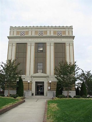
Person County is a county located in the U.S. state of North Carolina. The population was 39,097 as of the 2020 census. The county seat is Roxboro.

Harris County is a county located in the west-central portion of the U.S. state of Georgia; its western border with the state of Alabama is formed by the Chattahoochee River. As of the 2020 census, the population was 34,668. The county seat is Hamilton. The largest city in the county is Pine Mountain, a resort town that is home to the Franklin D. Roosevelt State Park. Harris County was created on December 14, 1827, and named for Charles Harris, a Georgia judge and attorney. Harris County is part of the Columbus, GA-AL metropolitan area and has become a popular suburban and exurban destination of residence for families relocating from Columbus. Because of this, Harris has become the sixth-wealthiest county in Georgia in terms of per capita income and the wealthiest in the state outside of Metro Atlanta.

Lawrenceville is a city in and the county seat of Gwinnett County, Georgia, United States. It is a suburb of Atlanta, located approximately 30 miles (50 km) northeast of downtown. It was incorporated on December 15, 1821. As of the 2020 census, the population of Lawrenceville was 30,629.

Walters is a town in Cotton County, Oklahoma, United States. The population was 2,412 as of the 2020 United States census. The city, nestled between twin creeks, is the county seat of Cotton County. The city's motto is "Small town; Big heart".

The Piedmont is a plateau region located in the Eastern United States. It is situated between the Atlantic Plain and the Blue Ridge Mountains, stretching from New York in the north to central Alabama in the south. The Piedmont Province is a physiographic province of the larger Appalachian Highlands physiographic division and consists of the Piedmont Upland, and the Piedmont Lowlands sections.

Black Hills National Forest is located in southwestern South Dakota and northeastern Wyoming, United States. The forest has an area of over 1.25 million acres (5,066 km2) and is managed by the Forest Service. Forest headquarters are located in Custer, South Dakota. There are local ranger district offices in Custer, Rapid City, and Spearfish in South Dakota, and in Sundance, Wyoming.

Cannelton Cotton Mill, also known as Indiana Cotton Mill, is a National Historic Landmark of the United States located in Cannelton, Indiana, United States. Built in 1849 as an effort to expand textile milling out of New England, it was the largest industrial building west of the Allegheny Mountains, designed by Thomas Alexander Tefft, an early industrial architect. It was declared a National Historic Landmark in 1991. The building now houses residences.

The Upland South and Upper South are two overlapping cultural and geographic subregions in the inland part of the Southern United States. They differ from the Deep South and Atlantic coastal plain by terrain, history, economics, demographics, and settlement patterns.

Berlin Mountain is a 2,818-foot-tall (859 m) prominent peak in the Taconic Mountains of western New England and is located adjacent to Massachusetts's border with New York State. It is the highest point in Rensselaer County. The summit and west side of the mountain are located in New York; the east side lies within Williamstown, Massachusetts. The mountain is a bald, notable for its grassy summit and expansive views of the Hudson River Valley to the west. The 37-mile (60 km) Taconic Crest Trail traverses the mountain. Several other hiking trails approach the summit from the east. Much of the upper slopes and summit are within protected conservation land. Historically the lower slopes of the mountain were farmed heavily throughout the 19th Century. In addition to agriculture, there are several remnants of charcoal kilns located on the mountain that produced fuel for iron smelting.

McCauley Mountain is a summit and ski resort in the Town of Webb, Herkimer County, New York. It is located just outside the hamlet of Old Forge, in the south-western area of the Adirondack Mountains.

Rum Hill is a mountain located in Central New York Region of New York northwest of the Hamlet of Pierstown. Red House Hill is located southeast, Metcalf Hill is located south, Allen Lake and Mohegan Hill are located north-northwest and Otsego Lake is located east of Rum Hill.
Red House Hill is a mountain in the Central New York Region of the State of New York, United States. It is located south-southwest of the Hamlet of Springfield Center, New York, west of Hutter Point and Six Mile Point of Otsego Lake, and southeast of Rum Hill. Mohican Brook flows eastward along the southern edge of the hill.
Frost Hill is a mountain in the Finger Lakes Region of New York. It is located west of Bristol Springs in Ontario County. At an elevation of 2,284 feet (696 m), the mountain is the highest point in Ontario County. It is about 1.25 miles (2.01 km) southwest of the 2,150-foot (660 m) Worden Hill, where Bristol Mountain Ski Resort is.
Red Hill is a mountain located in the Catskill Mountains of New York east-south of Frost Valley. Woodhull Mountain is located northeast of Red Hill.
Gallis Hill is a 794-foot-tall (242 m) mountain in the Catskill Mountains region of New York. It is located northwest of Kingston in Ulster County. Jockey Hill is located north-northeast, and Morgan Hill is located west of Gallis Hill. In 1927, the Conservation Department built a steel fire lookout tower on the mountain. In 1950, the tower was closed and disassembled then moved to Overlook Mountain, where it still remains today.
Leonard Hill is a 2,592-foot-tall (790 m) mountain in Schoharie County, New York. It is located east-southeast of North Blenheim. Safford Hill is located northwest and Hubbard Hill is located southeast of Leonard Hill. In 1948, the Conservation Commission built an 80-foot-tall (24 m) steel fire lookout tower on the mountain. The tower ceased fire watching operations at the end of the 1988 season and was officially closed in early 1989. The tower remains on the summit, but is closed to the public. A local group is planning to restore the tower and reopen it to the public.
Washburn Mountain is a 1,496-foot-tall (456 m) mountain in New York. It is located south-southeast Copake Falls in Columbia County. From 1932 to 1964, the mountain was the location of a 60-foot-tall (18 m) steel fire lookout tower now located on Beebe Hill. Alander Mountain is located southeast of Washburn Mountain.

