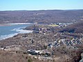
Highlands is a town on the eastern border of Orange County, New York. The population was 12,939 at the 2020 census. West Point, including the United States Military Academy, is located alongside the Hudson River in Highlands.

Esopus is a town in Ulster County, New York, United States. The population was 9,548 at the 2020 census. The town was named after the local indigenous tribe and previously thought to mean "small river" in English. However, in the Lenape` language, the word translates to "Wellspring of Creation". The Esopus people were one of the Lenape (Delaware) bands, belonging to a people who ranged from western Connecticut through lower New York, western Long Island, and parts of New Jersey and Pennsylvania along the Delaware River. The town is on the west bank of the Hudson River south of the city of Kingston. Its center is in Port Ewen. US Route 9W passes along the eastern side of the town.

Crowsnest Pass is a low mountain pass across the Continental Divide of the Canadian Rockies on the Alberta–British Columbia border.
The Palisades Interstate Parkway (PIP) is a 38.25-mile (61.56 km) controlled-access parkway in the U.S. states of New Jersey and New York. The parkway is a major commuter route into New York City from Rockland and Orange counties in New York and Bergen County in New Jersey. The southern terminus of the route is at the George Washington Bridge in Fort Lee, New Jersey, where it connects to Interstate 95 (I-95), US 1-9, and US 46. Its northern terminus is at a traffic circle in Fort Montgomery, New York, where the PIP meets US 9W and US 202 at the Bear Mountain Bridge. At exit 18, the PIP forms a concurrency with US 6 for the remaining duration of its run.
U.S. Route 9W (US 9W) is a north–south United States Numbered Highway in the states of New Jersey and New York. It begins in Fort Lee, New Jersey, as Fletcher Avenue crosses the US 1/9, US 46, and Interstate 95 (I-95) approaches to the George Washington Bridge, and heads north up the west side of the Hudson River to US 9 in Albany, New York. As its "W" suffix indicates, US 9W is a westerly alternate route of US 9 between the two locations. US 9W directly serves three cities—Newburgh, Kingston, and Albany—and enters the vicinity of several others. As the route heads north, it connects to several highways of regional importance, including I-84, US 209, New York State Route 23 (NY 23), and US 20. Much of US 9W parallels the New York State Thruway and NY 32; additionally, the latter overlaps with US 9W in four different locations.

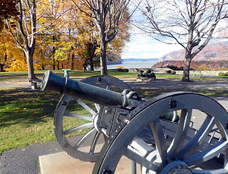
Hudson Highlands State Park is a non-contiguous state park in the U.S. state of New York, located on the east side of the Hudson River. The park runs from Peekskill in Westchester County, through Putnam County, to Beacon in Dutchess County, in the eastern section of the Hudson Highlands.

Breakneck Ridge is a mountain along the Hudson River between Beacon and Cold Spring, New York, straddling the boundary between Dutchess and Putnam counties. Its distinctive rocky cliffs are visible for a long distance when approached from the south, and together with Storm King Mountain on the opposite bank of the river forms Wey-Gat, or Wind Gate, the picturesque northern gateway to the Hudson Highlands.

Storm King Mountain is a mountain on the west bank of the Hudson River just south of Cornwall-on-Hudson, New York. Together with Breakneck Ridge on the opposite bank of the river it forms "Wey-Gat" or Wind Gate, the picturesque northern narrows of the Hudson Highlands. Its distinctive curved ridge is the most prominent aspect of the view south down Newburgh Bay, from Newburgh, Beacon, and the Newburgh-Beacon Bridge. It can also be seen by southbound travelers on nearby sections of the New York State Thruway. This view was a popular subject for early artists of the Hudson River School.

The Hudson Highlands are mountains on both sides of the Hudson River in New York state lying primarily in Putnam County on its east bank and Orange County on its west. They continue somewhat to the south in Westchester County and Rockland County, respectively. The highlands are a subrange of the Appalachian Mountains.

New York State Route 218 (NY 218) is a state highway located within Orange County, New York, in the United States. It loops off U.S. Route 9W to run closer to the Hudson River between Highland Falls and Cornwall-on-Hudson. North of Highland Falls, it is briefly concurrent with US 9W.

New York State Route 293 (NY 293) is a 6.82-mile (10.98 km) state highway located entirely within eastern Orange County, New York, in the United States. The highway starts at U.S. Route 6 in Woodbury, and heads to the northeast, ending at an intersection with US 9W and NY 218 in the community of Highlands. It does not pass through any notable populated areas as most of the land around it is protected either as state parkland or US military reservation. However, it receives much traffic as the major route between the United States Military Academy at West Point and the New York State Thruway.
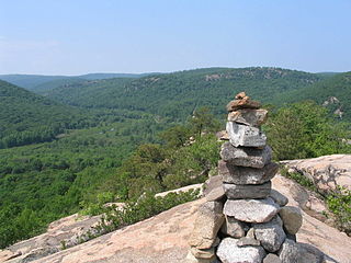
Popolopen is the name of several related landmarks mainly within the Hudson Highlands of Orange County, New York. These include a peak, Popolopen Torne—or simply "The Torne", and a short and steep-sided nearby valley officially called Hell Hole, but often Popolopen Gorge. Popolopen Creek runs through this valley. The Popolopen Bridge spans its mouth at the Hudson River and is crossed by Route 9W. Popolopen Lake feeds the headwaters of its namesake creek. Despite local usage, the United States Board on Geographical Names recognizes only the lake, creek and bridge as bearing the name "Popolopen."

Kaaterskill High Peak is one of the Catskill Mountains, located in the Town of Hunter in Greene County, New York, United States. It was once believed to be the highest peak in the entire range, but its summit, at 3,655 feet (1,114 m) in elevation, places it only 23rd among the Catskill High Peaks. It is, however, the fourth most prominent peak in the range. Due to its situation as the easternmost High Peak, its summit is just outside the watersheds of New York City's reservoirs in the region.

New York State Route 23A (NY 23A) is an east–west state highway in Greene County, New York, in the United States. It serves as a 34.56-mile (55.62 km) alternate route of NY 23 through the northern Catskill Mountains. The route passes several of the Catskill High Peaks, including Hunter Mountain, before dropping into the Hudson Valley via Kaaterskill Clove and ending at an intersection with U.S. Route 9W (US 9W) in the village of Catskill. NY 23A was assigned in the mid-1920s and has not been changed since. A portion of the route through Kaaterskill Clove was closed for several months in 2006 after landslides triggered by heavy rains damaged the route.

U.S. Route 6 (US 6) in New York is a 77.85-mile (125.29 km) stretch of United States Numbered Highway that spans from the Pennsylvania state line at Port Jervis to the Connecticut state line east of Brewster. Near both ends it runs in close proximity to Interstate 84 (I-84), which otherwise takes a more northerly route through Downstate New York. US 6, meanwhile, skirts the northern fringe of the New York metropolitan area.
Tomkins Cove is a hamlet in the Town of Stony Point, Rockland County, New York, United States, located north of Stony Point; east of Harriman State Park; south of Doodletown and west of the Hudson River. It is located north-northwest of New York City. The population is approximately 1,739 and the ZIP Code is 10986. The community is served by the 786 exchange in area code 845.
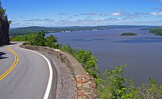
The Storm King Highway is a three-mile (4.8 km) segment of New York State Route 218 (NY 218) between Lee Road in the Town of Highlands at the south end and the Cornwall-on-Hudson village line in Orange County, New York, in the United States. It was built in 1916 and added to the National Register of Historic Places in 1982 in recognition of its accomplishment in civil engineering.

U.S. Route 202 (US 202) is a part of the U.S. Highway System that runs from New Castle, Delaware, to Bangor, Maine. In the U.S. state of New York, US 202 extends 55.57 miles (89.43 km) from the New Jersey state line near Suffern to the Connecticut state line east of Brewster. While most of US 202 is signed north–south, the portion within New York is signed east–west. It drifts north slowly as it crosses southern New York. US 202 is the only road to cross New York between New Jersey and Connecticut and not pass through New York City on the way.

Brace Mountain is the peak of a ridge in the southern Taconic Mountains, near the tripoint of the U.S. states of New York, Connecticut and Massachusetts. Its 2,311-foot (704 m) main summit is located in New York; it is the highest point in that state's Dutchess County.
Dunderberg Mountain is a 1,086-foot (331 m) mountain on the west bank of the Hudson River at the southern end of the Hudson Highlands. It lies just above Jones Point, New York, within Bear Mountain State Park and the town of Stony Point in Rockland County, New York.