
The Allegheny River is a 325-mile-long (523 km) tributary of the Ohio River that is located in western Pennsylvania and New York in the United States. It runs from its headwaters just below the middle of Pennsylvania's northern border, northwesterly into New York, then in a zigzag southwesterly across the border and through Western Pennsylvania to join the Monongahela River at the Forks of the Ohio at Point State Park in Downtown Pittsburgh, Pennsylvania.

The Crow, whose autonym is Apsáalooke, also spelled Absaroka, are Native Americans living primarily in southern Montana. Today, the Crow people have a federally recognized tribe, the Crow Tribe of Montana, with an Indian reservation, the Crow Indian Reservation, located in the south-central part of the state.

Big Horn County is a county located in the U.S. state of Montana. As of the 2020 census, the population was 13,124. The county seat is Hardin. The county, like the river and the mountain range, is named after the bighorn sheep in the Rocky Mountains. The county was founded in 1913. It is located on the south line of the state.

Crow Agency is a census-designated place (CDP) in Big Horn County, Montana, United States and is near the actual location for the Little Bighorn National Monument and re-enactment produced by the Real Bird family known as Battle of the Little Bighorn Reenactment. The population was 1,616 at the 2010 census. It is the governmental headquarters of the Crow Nation Native Americans. It is also the location of the "agency offices" where the federal Superintendent of the Crow Indian Reservation and his staff interacts with the Crow Tribe, pursuant to federal treaties and statutes.

Indian Lake is a town in Hamilton County, New York, United States. The population was 1,352 at the 2010 census. The name is from a lake of the same name that is largely inside the town. There are no permanent stop lights in the town. Law enforcement is provided by New York State Troopers and Hamilton County Sheriff's Office.

The Bighorn Mountains are a mountain range in northern Wyoming and southern Montana in the United States, forming a northwest-trending spur from the Rocky Mountains extending approximately 200 mi (320 km) northward on the Great Plains. They are separated from the Absaroka Range, which lie on the main branch of the Rockies to the west, by the Bighorn Basin. Much of the land is contained within the Bighorn National Forest.

Little people have been part of the folklore of many cultures in human history, including Ireland, Greece, the Philippines, the Hawaiian Islands, New Zealand, Flores Island, Indonesia, and Native Americans.
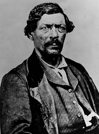
James Pierson Beckwourth was an American fur trapper, rancher, businessman, explorer, author and scout. Known as "Bloody Arm" because of his skill as a fighter, Beckwourth was of multiracial descent, being born into slavery in Frederick County, Virginia. He was eventually emancipated by his enslaver, who was also his father, and apprenticed to a blacksmith so that he could learn a trade.

Bear Butte is a geological laccolith feature located near Sturgis, South Dakota, United States, that was established as a State Park in 1961. An important landmark and religious site for the Plains Indians tribes long before Europeans reached South Dakota, Bear Butte is called Matȟó Pahá, or Bear Mountain, by the Lakota, or Sioux. To the Cheyenne, it is known as Noahȧ-vose or Náhkȯhe-vose, and is the place where Ma'heo'o imparted to Sweet Medicine, a Cheyenne prophet, the knowledge from which the Cheyenne derive their religious, political, social, and economic customs.
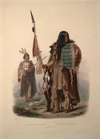
The Assiniboine or Assiniboin people, also known as the Hohe and known by the endonym Nakota, are a First Nations/Native American people originally from the Northern Great Plains of North America.

The Sioux Wars were a series of conflicts between the United States and various subgroups of the Sioux people which occurred in the later half of the 19th century. The earliest conflict came in 1854 when a fight broke out at Fort Laramie in Wyoming, when Sioux warriors killed 31 American soldiers in the Grattan Massacre, and the final came in 1890 during the Ghost Dance War.

Tuscarora State Park is a Pennsylvania state park on 1,618 acres (655 ha) in Rush, Ryan, Schuylkill Townships, Schuylkill County, Pennsylvania in the United States. The most prominent features of the park are Locust Mountain and Tuscarora Lake. The park is named for the Tuscarora Indians, who lived in the area, following the Tuscarora War in North Carolina, until they were forced out by the colonial settlers of Pennsylvania. Tuscarora State Park is 2 miles (3.2 km) west of Tamaqua just off of Pennsylvania Route 54.

The Wind River Indian Reservation, in the west-central portion of the U.S. state of Wyoming, is shared by two Native American tribes, the Eastern Shoshone and the Northern Arapaho. Roughly 60 mi (97 km) east to west by 50 mi (80 km) north to south, the Indian reservation is located in the Wind River Basin, and includes portions of the Wind River Range, Owl Creek Mountains, and Absaroka Range.

The Crow Indian Reservation is the homeland of the Crow Tribe. Established 1868, the reservation is located in parts of Big Horn, Yellowstone, and Treasure counties in southern Montana in the United States. The Crow Tribe has an enrolled membership of approximately 11,000, of whom 7,900 reside in the reservation. 20% speak Crow as their first language.

The Black Hills is an isolated mountain range rising from the Great Plains of North America in western South Dakota and extending into Wyoming, United States. Black Elk Peak, which rises to 7,242 feet (2,207 m), is the range's highest summit. The name of the range in Lakota is Pahá Sápa. It encompasses the Black Hills National Forest. It formed as a result of an upwarping of ancient rock, after which the removal of the higher portions of the mountain mass by stream erosion produced the present-day topography. The hills are so called because of their dark appearance from a distance, as they are covered in evergreen trees.

The Regional designations of Montana vary widely within the U.S state of Montana. The state is a large geographical area that is split by the Continental Divide, resulting in watersheds draining into the Pacific Ocean, Gulf of Mexico and Hudson's Bay. The state is approximately 545 miles (877 km) east to west along the Canada–United States border and 320 miles (510 km) north to south. The fourth largest state in land area, it has been divided up in official and unofficial ways into a variety of regions. Additionally, Montana is part of a number of larger federal government administrative regions.

The Crow War, also known as the Crow Rebellion, or the Crow Uprising, was the only armed conflict between the United States and the Crow tribe of Montana, and the last Indian War fought in the state. In September 1887, the young medicine man Wraps-Up-His-Tail, or Sword Bearer, led a small group of warriors in a raid against a group of Blackfoot which had captured horses from the Crow reservation. Following the raid, Sword Bearer led his group back to the Crow Agency to inform the Indian agent of his victory, but an incident arose which ended with the young leader taking his followers into the mountains. In response, the United States Army launched a successful campaign to bring the Crow back to the reservation.

The Albion Mountains are a mountain range in the U.S. states of Idaho (~99%) and Utah (~1%), spanning Cassia County, Idaho and barely reaching into Box Elder County, Utah. The highest point in the range is Cache Peak at 10,339 feet (3,151 m), and the range is a part of the Basin and Range Province. Most of the mountains are part of the Albion Division of the Minidoka Ranger District of Sawtooth National Forest.

Rum Hill is a mountain located in Central New York Region of New York northwest of the Hamlet of Pierstown. Red House Hill is located southeast, Metcalf Hill is located south, Allen Lake and Mohegan Hill are located north-northwest and Otsego Lake is located east of Rum Hill.
Bell Mountain is a mountain located in Adirondack Mountains of New York located in the Town of Indian Lake east of Indian Lake.

