Dennison, Ohio

Last updated

Dennison, Ohio
Dennison Depot.jpg
OHMap-doton-Dennison.png
Location of Dennison, Ohio
Map of Tuscarawas County Ohio Highlighting Dennison Village.png
Location of Dennison in Tuscarawas County
Coordinates: 40°23′52″N81°19′38″W / 40.39778°N 81.32722°W / 40.39778; -81.32722
Country United States
State Ohio
County Tuscarawas
Townships Mill, Union
Area
[1]
  Total1.38 sq mi (3.57 km2)
  Land1.38 sq mi (3.57 km2)
  Water0.00 sq mi (0.00 km2)
Elevation
[2]
863 ft (263 m)
Population
 (2020)
  Total2,709
  Estimate 
(2023) [3]
2,653
  Density1,963.04/sq mi (757.81/km2)
Time zone UTC-5 (Eastern (EST))
  Summer (DST) UTC-4 (EDT)
ZIP code
44621
Area code 740
FIPS code 39-21714 [4]
GNIS feature ID2398712 [2]

Dennison is a village in Tuscarawas County, Ohio, United States. The population was 2,709 at the 2020 census.

Contents

History

The confluence of coal and railroads drove the development of Dennison. It is located at the midpoint between Pittsburgh and Columbus -- 100 miles (160 km) from each. At the time, locomotives needed water every 100 miles (160 km), so Dennison was a natural refilling location. The Dennison Coal Company had mines south of town.

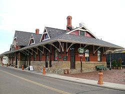
In 1864, The Pittsburgh, Cincinnati & St. Louis Railway decided to locate the country's largest railroad shops and yards in Dennison. Dennison Land Company laid out the town of Dennison in 1865 and purchased land expressly for the town. The railyards spanned 40 acres (160,000 m2). Demand for passenger service led to construction of a station in 1873. Thousands moved to the area for jobs in the roundhouses, turntables and foundries. At its peak, 3,000 people worked in the railyards. The Pennsylvania Railroad Company eventually subsumed the Pittsburgh, Cincinnati & St. Louis Railway.

The village incorporated in 1873, and was named for governor William Dennison. [5]

During World War I, the Red Cross operated a canteen from a boxcar. Canteen volunteers prepared coffee and sandwiches for troops traveling through by train.

In 1922, a strike marked the end of the golden era of Dennison. During World War II, the Dennison Canteen operated from March 19, 1942, to April 8, 1946. Initially in a gas station on Center and Fifth Street, it moved to the depot restaurant and was dubbed "Dreamsville".

The last passenger train service stopped in 1968. The last freight train stop in Dennison was in 1982. Freight trains still roll through, but they no longer stop in Dennison.

Geography

According to the United States Census Bureau, the village has a total area of 1.35 square miles (3.50 km2), all land. [6]

Climate

Climate data for Dennison, Ohio (1991–2020 normals, extremes 1909–present)
MonthJanFebMarAprMayJunJulAugSepOctNovDecYear
Record high °F (°C)75
(24)
78
(26)
86
(30)
93
(34)
99
(37)
101
(38)
105
(41)
105
(41)
101
(38)
93
(34)
82
(28)
72
(22)
105
(41)
Mean daily maximum °F (°C)35.7
(2.1)
39.6
(4.2)
49.6
(9.8)
62.6
(17.0)
73.0
(22.8)
81.1
(27.3)
84.8
(29.3)
83.3
(28.5)
76.5
(24.7)
64.2
(17.9)
51.4
(10.8)
40.5
(4.7)
61.9
(16.6)
Daily mean °F (°C)27.6
(−2.4)
30.5
(−0.8)
38.9
(3.8)
50.2
(10.1)
60.7
(15.9)
69.1
(20.6)
73.1
(22.8)
71.4
(21.9)
64.2
(17.9)
52.5
(11.4)
41.8
(5.4)
32.9
(0.5)
51.1
(10.6)
Mean daily minimum °F (°C)19.6
(−6.9)
21.4
(−5.9)
28.3
(−2.1)
37.7
(3.2)
48.4
(9.1)
57.1
(13.9)
61.4
(16.3)
59.4
(15.2)
51.9
(11.1)
40.8
(4.9)
32.2
(0.1)
25.2
(−3.8)
40.3
(4.6)
Record low °F (°C)−33
(−36)
−22
(−30)
−11
(−24)
5
(−15)
18
(−8)
30
(−1)
38
(3)
33
(1)
26
(−3)
11
(−12)
−9
(−23)
−24
(−31)
−33
(−36)
Average precipitation inches (mm)3.13
(80)
2.51
(64)
3.53
(90)
3.90
(99)
3.78
(96)
4.43
(113)
4.13
(105)
4.06
(103)
3.39
(86)
3.28
(83)
3.12
(79)
3.10
(79)
42.36
(1,076)
Average precipitation days (≥ 0.01 in)11.59.811.813.514.112.110.69.69.210.710.611.7135.2
Source: NOAA [7] [8]

Demographics

Historical population
CensusPop.Note
1870 828
1880 1,51883.3%
1890 2,92592.7%
1900 3,76328.6%
1910 4,0086.5%
1920 5,52437.8%
1930 4,529−18.0%
1940 4,413−2.6%
1950 4,4320.4%
1960 4,158−6.2%
1970 3,506−15.7%
1980 3,398−3.1%
1990 3,282−3.4%
2000 2,992−8.8%
2010 2,655−11.3%
2020 2,7092.0%
2023 (est.)2,653 [3] −2.1%
U.S. Decennial Census [9]

2010 census

As of the census [10] of 2010, there were 2,655 people, 1,043 households, and 693 families living in the village. The population density was 1,966.7 inhabitants per square mile (759.3/km2). There were 1,194 housing units at an average density of 884.4 per square mile (341.5/km2). The racial makeup of the village was 96.8% White, 1.0% African American, 0.4% Native American, 0.2% Asian, 0.2% from other races, and 1.4% from two or more races. Hispanic or Latino of any race were 1.0% of the population.

There were 1,043 households, of which 34.7% had children under the age of 18 living with them, 45.5% were married couples living together, 14.7% had a female householder with no husband present, 6.2% had a male householder with no wife present, and 33.6% were non-families. 28.1% of all households were made up of individuals, and 13.5% had someone living alone who was 65 years of age or older. The average household size was 2.54 and the average family size was 3.09.

The median age in the village was 35.5 years. 26.6% of residents were under the age of 18; 8.3% were between the ages of 18 and 24; 27.7% were from 25 to 44; 25.3% were from 45 to 64; and 12.2% were 65 years of age or older. The gender makeup of the village was 48.8% male and 51.2% female.

2000 census

As of the census [4] of 2000, there were 2,992 people, 1,132 households, and 822 families living in the village. The population density was 2,174.5 inhabitants per square mile (839.6/km2). There were 1,233 housing units at an average density of 896.1 per square mile (346.0/km2). The racial makeup of the village was 96.19% White, 1.64% African American, 0.20% Native American, 0.10% Asian, 0.10% Pacific Islander, 0.37% from other races, and 1.40% from two or more races. Hispanic or Latino of any race were 1.00% of the population.

There were 1,132 households, out of which 36.7% had children under the age of 18 living with them, 52.8% were married couples living together, 14.0% had a female householder with no husband present, and 27.3% were non-families. 24.3% of all households were made up of individuals, and 12.7% had someone living alone who was 65 years of age or older. The average household size was 2.62 and the average family size was 3.09.

In the village, the population was spread out, with 28.1% under the age of 18, 10.0% from 18 to 24, 27.5% from 25 to 44, 20.3% from 45 to 64, and 14.1% who were 65 years of age or older. The median age was 34 years. For every 100 females there were 95.7 males. For every 100 females age 18 and over, there were 91.1 males.

The median income for a household in the village was $29,020, and the median income for a family was $32,168. Males had a median income of $27,679 versus $19,490 for females. The per capita income for the village was $13,389. About 12.3% of families and 17.2% of the population were below the poverty line, including 25.6% of those under age 18 and 12.5% of those age 65 or over.

This model of the Dennison Depot and Railyard is a current exhibit at the Dennison Railroad Depot Museum. 20060128 15-35-15DennisonNscale.JPG
This model of the Dennison Depot and Railyard is a current exhibit at the Dennison Railroad Depot Museum.

Notable people

Related Research Articles

<span class="mw-page-title-main">Essex Village, Connecticut</span> Census-designated place in Connecticut, United States

Essex Village is a village and census-designated place (CDP) in the town of Essex, Connecticut, in the United States. The population was 2,583 at the 2020 census, out of 6,733 in the entire town of Essex. The government offices of the town are located within the village.

<span class="mw-page-title-main">Thornburg, Iowa</span> City in Iowa, United States

Thornburg is a village in Keokuk County, Iowa, United States. The population was 45 at the time of the 2020 census. Its sole enterprise is the Tri-County Community School, a public school serving grades K-12.

<span class="mw-page-title-main">Fowler, Michigan</span> Village in Michigan, United States

Fowler is a village in Clinton County in the U.S. state of Michigan. The population was 1,226 at the 2020 census. The village is located within Dallas Township.

<span class="mw-page-title-main">Harris, Minnesota</span> City in Minnesota, United States

Harris is a city in Chisago County, Minnesota, United States. The population was 1,132 at the 2010 census. There is a restaurant, a post office, a bar and grill, and tattoo shop, among other businesses. Interstate 35 serves as a main route for the community.

<span class="mw-page-title-main">Lancaster, Minnesota</span> City in Minnesota, United States

Lancaster is a city in Kittson County, Minnesota, United States. As of the 2020 census, the city population was 364.

<span class="mw-page-title-main">Butterfield, Missouri</span> City in Missouri, United States

Butterfield is a city in Butterfield Township, Barry County, Missouri, United States. The population was 378 at the 2020 census.

<span class="mw-page-title-main">South Greenfield, Missouri</span> Village in Missouri, United States

South Greenfield is a village in Dade County, Missouri, United States. The population was 122 at the 2020 census.

<span class="mw-page-title-main">Freeburg, Missouri</span> Village in Missouri, United States

Freeburg is a village in Osage County, Missouri, United States. The population was 409 at the 2020 census. It is part of the Jefferson City, Missouri Metropolitan Statistical Area.

<span class="mw-page-title-main">Osgood, Missouri</span> Village in Missouri, United States

Osgood is a village in western Sullivan County, Missouri, United States. The population was 24 at the 2020 census.

<span class="mw-page-title-main">Stotesbury, Missouri</span> Village in Missouri, United States

Stotesbury is a village in northwest Vernon County, Missouri, United States. The population was 18 at the 2010 census.

<span class="mw-page-title-main">Comstock, Nebraska</span> Village in Custer County, Nebraska, United States

Comstock is a village in Custer County, Nebraska, United States. The population was 93 at the 2010 census.

<span class="mw-page-title-main">Hardy, Nebraska</span> Village in Nuckolls County, Nebraska, United States

Hardy is a village in Nuckolls County, Nebraska, United States. The population was 159 at the 2010 census.

<span class="mw-page-title-main">Cornlea, Nebraska</span> Village in Platte County, Nebraska, United States

Cornlea is a village in Platte County, Nebraska, United States. The population was 36 at the 2010 census.

<span class="mw-page-title-main">Belvidere, Nebraska</span> Village in Thayer County, Nebraska, United States

Belvidere is a village in Thayer County, Nebraska, United States. The population was 51 at the 2020 census.

<span class="mw-page-title-main">Herman, Nebraska</span> Village in Washington County, Nebraska, United States

Herman is a village in Washington County, Nebraska, United States. The population was 268 at the 2010 census.

<span class="mw-page-title-main">Minoa, New York</span> Village in New York, United States

Minoa is a village in Onondaga County, New York, United States. As of the 2020 census, the population was 3,657. Minoa is in the northern part of the town of Manlius and is east of Syracuse.

<span class="mw-page-title-main">Rossburg, Ohio</span> Village in Ohio, United States

Rossburg is a village in Darke County, Ohio, United States. The population was 159 at the 2020 census.

<span class="mw-page-title-main">Exeland, Wisconsin</span> Village in Wisconsin, United States

Exeland is a village in Sawyer County, Wisconsin, United States. The population was 229 at the 2020 census.

<span class="mw-page-title-main">Cecil, Wisconsin</span> Village in Wisconsin, United States

Cecil is a village in Shawano County, Wisconsin, United States. The population was 529 at the 2020 census.

<span class="mw-page-title-main">Ridgeway, Ohio</span> Village in Ohio, United States

Ridgeway is a village in Hardin and Logan counties in the U.S. state of Ohio. The population was 314 at the 2020 census.

References

  1. "ArcGIS REST Services Directory". United States Census Bureau. Retrieved September 20, 2022.
  2. 1 2 U.S. Geological Survey Geographic Names Information System: Dennison, Ohio
  3. 1 2 "Annual Estimates of the Resident Population for Incorporated Places in Ohio: April 1, 2020 to July 1, 2023". United States Census Bureau. Retrieved June 16, 2024.
  4. 1 2 "U.S. Census website". United States Census Bureau . Retrieved January 31, 2008.
  5. Gannett, Henry (1905). The Origin of Certain Place Names in the United States. Govt. Print. Off. p. 104.
  6. "US Gazetteer files 2010". United States Census Bureau. Archived from the original on January 25, 2012. Retrieved January 6, 2013.
  7. "NowData – NOAA Online Weather Data". National Oceanic and Atmospheric Administration. Retrieved August 7, 2021.
  8. "Station: Dennison WTR WKS, OH". U.S. Climate Normals 2020: U.S. Monthly Climate Normals (1991-2020). National Oceanic and Atmospheric Administration. Retrieved August 7, 2021.
  9. "Census of Population and Housing". Census.gov. Retrieved June 4, 2015.
  10. "U.S. Census website". United States Census Bureau . Retrieved January 6, 2013.