
The Texas Hill Country is a geographic region of Central and South Texas, forming the southeast part of the Edwards Plateau. Given its location, climate, terrain, and vegetation, the Hill Country can be considered the border between the American Southeast and Southwest. The region represents the very remote rural countryside of Central Texas, but also is home to growing suburban neighborhoods and affluent retirement communities.
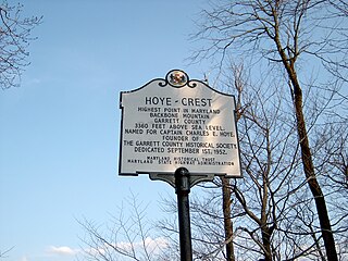
Backbone Mountain is a ridge of the Allegheny Mountains of the central Appalachian Mountain Range. It is situated in the U.S. states of West Virginia and Maryland and forms a portion of the Eastern Continental Divide. Within the state of Maryland, Backbone Mountain reaches an elevation of 3,360 feet or 1,024 metres, making it Maryland's highest point.

Mount San Antonio, commonly referred to as Mount Baldy or Old Baldy, is a 10,064 ft (3,068 m) summit in the San Gabriel Mountains on the border of Los Angeles and San Bernardino counties of California. Lying within the San Gabriel Mountains National Monument and Angeles National Forest, it is the highest point within the mountain range, the County of Los Angeles, and the Los Angeles metropolitan area.
The Battle of Devil's Backbone, also known as the Action at Devil's Backbone, was a military engagement in the Trans-Mississippi Theater of the American Civil War. Devil's Backbone is a ridge in the Ouachita Mountains approximately 4 miles (6.4 km) southwest of Greenwood, Arkansas. The battle was fought on September 1, 1863, in Sebastian County, Arkansas. The Union victory ensured the safety of the Fort Smith garrison until the end of the war.
Devil's Backbone may refer to:

Mark Twain National Forest (MTNF) is a U.S. National Forest located in the southern half of Missouri, composed of nine disconnected parcels. MTNF was established on September 11, 1939. It is named for author Mark Twain, a Missouri native. The MTNF covers 3,068,800 acres (12,419 km2) of which 1,506,100 acres (6,095 km2) is public owned, 78,000 acres (320 km2) of which are Wilderness, and National Scenic River area. MTNF spans 29 counties and represents 11% of all forested land in Missouri. MTNF's nine tracts are divided into six distinct ranger districts: Ava-Cassville-Willow Springs, Eleven Point, Houston-Rolla, Cedar Creek, Poplar Bluff, Potosi-Fredericktown, and the Salem. Its headquarters are in Rolla, Missouri.
The Devils Backbone Wilderness is one of eight wilderness areas protected and preserved in the U.S. State of Missouri. The United States Congress designated the wilderness area in 1980, and it now has a total of 6,595 acres (26 km2). Devil's Backbone is located within the Willow Springs section of the Ava-Cassville-Willow Springs Ranger District, of the Mark Twain National Forest, near Willow Springs, Missouri. It was named for a prominent ridge down the center of the area. Horseback riding is popular on a network of trails in the wilderness.
The Piney Creek Wilderness is an 8,122-acre (33 km2) wilderness area in Missouri. The United States Congress designated it wilderness in 1980. The Piney Creek Wilderness is located within the Ava-Cassville-Willow Springs Ranger District of the Mark Twain National Forest, east of Cassville, Missouri. The area is named after Piney Creek, which runs the length of the wilderness area and eventually empties into the James River arm of Table Rock Lake. The Piney Creek Wilderness is one of eight wilderness areas of the Mark Twain National Forest that are protected and preserved in Missouri.

The United States Congress designated the Bell Mountain Wilderness in 1980. The wilderness area now has a total of 9,027 acres (36.53 km2). Bell Mountain is located within the Potosi-Fredericktown Ranger District of the Mark Twain National Forest, south of Potosi, Missouri in the United States. The wilderness lies in the Saint Francois Mountains and it was named after its highest point, Bell Mountain. The namesake Bell Mountain has the name of Henry Bell, a pioneer settler. The Bell Mountain Wilderness is one of eight wilderness areas protected and preserved in Missouri. The area is popular for hiking as there are 12 miles (19 km) of trail, including a section of the Ozark Trail.
The Paddy Creek Wilderness is a 7,019-acre (28.40 km2) wilderness area in the U.S. state of Missouri, United States. The United States Congress designated it wilderness in 1983. Paddy Creek Wilderness is located within the Houston-Rolla Ranger District, of the Mark Twain National Forest, 10 miles (16 km) northwest of Licking, Missouri. It was named for Big and Little Paddy Creeks that run through the area. The Paddy Creek Wilderness is one of eight wilderness areas protected and preserved in Missouri. Big Piney Trail is a 17-mile (27 km) long loop that traverses this wilderness area and is popular among avid backpackers. The 17-mile (27 km) loop trail can be hiked as a 10-mile (16 km) stretch or the 7.5-mile (12.1 km) south section. The trails are rugged and can be challenging for the inexperienced or unprepared hiker. Horseback riding is also common on the Piney Creek Trail. The Paddy Creek Recreation Area is nearby, and offers many camping amenities. There are many single sites, and a few double sites available. There is also fishing access on the Big Piney River, via a trail access from the campground.

The Magdalena Mountains are a regionally high, mountain range in Socorro County, in west-central New Mexico in the southwestern United States. The highest point in the range is South Baldy, at 10,783 ft, which is also the tallest peak in Socorro County. The range runs roughly north–south and is about 18 miles (28 km) long. The range lies just south of the village of Magdalena, and about 18 miles (28 km) west of Socorro. The Magdalena Mountains are an east-tilted fault-block range, superimposed on Cenozoic calderas. The complex geologic history of the range has resulted in spectacular scenery, with unusual and eye-catching rock formations. They form part of the western edge of the Rio Grande Rift Valley, fronting the La Jencia Basin. The mountains remain isolated and natural due to the absence of any significant human development within or near the range.
Marmot is an unincorporated community in Clackamas County, Oregon, United States located in the Mount Hood Corridor. It is within the boundaries of the Villages at Mount Hood, on a ridge known as Devil's Backbone, which lies between the Sandy and Little Sandy rivers, along the historic Barlow Road.

Mount Harwood is the first summit east of Mount San Antonio. The United States Geological Survey recognized the name to honor California educator and conservationist Aurelia Squire Harwood in 1965. Prior to this, the peak now known as Thunder Mountain was also referred to as Mount Harwood. Mount Harwood is located on the East side of the San Gabriel Mountains in the Angeles National Forest near the San Bernardino-Los Angeles county border. In this area of the San Gabriel Mountains the peaks are the highest. Because of the elevation Mount Harwood turns out to be ranked the 4th highest peak in the San Gabriel mountains after Dawson Peak, Mount San Antonio or "Old Baldy" being the highest at 10,064 feet. The only way for hikers or tourists to access Mount Harwood is to take Mt. Baldy Road off I-210. A National Forest Adventure pass/ National Park access pass must be displayed on a vehicle to access Mount Harwood.

Plateau Mountain is located in the town of Hunter in Greene County, New York, United States. It is part of the Devil's Path range of the Catskill Mountains. Plateau has a two-mile-long (3.2 km) summit ridge above 3,500 feet (1,100 m). The highest point, at least 3,840 feet (1,170 m), is at the southeast end, facing Sugarloaf Mountain to the east across Mink Hollow Notch. It is the 12th-highest peak in the range Devils Tombstone is located west of Plateau Mountain. The northwest end faces Hunter Mountain to the west across 1,400-foot deep (430 m) Stony Clove Notch.

Devils Head is a mountain summit in the Rampart Range of the Rocky Mountains of Colorado. The 9,749-foot (2,971 m) peak is located in Pike National Forest, 14.2 miles (22.9 km) southwest by south of the community of Sedalia in Douglas County, Colorado, United States.

The Devils Backbone Brewing Company is a brewpub located in Roseland, Virginia, owned by Anheuser-Busch InBev. It was established in 2008 by Steven Crandall. In 2012, a 15,000 square foot production facility and tap room, referred to as "The Outpost", was established near Lexington, Virginia. In 2016, the company was purchased by Anheuser-Busch InBev, meaning that Devils Backbone Brewing Company would no longer meet the Brewers Association definition of a "craft brewery", since ownership by Anheuser-Busch InBev exceeds the definition's 25% maximum ownership by a non-craft brewery.

Devils Backbone is a ridge and rock outcrop located in Highland County, Virginia, United States. The ridge is located approximately 7.6 miles (12.2 km) north-northeast of Monterey, Virginia near the village of Blue Grass.

Jenson Railroad Tunnel is the first and only railroad tunnel in the present state of Oklahoma. It was constructed through Backbone Mountain during 1885–86, by the Fort Smith & Southern Railway (FSSR). and has remained in service until the present. At the time it was built, the tunnel was located in the Choctaw Nation in Indian Territory. Since Oklahoma became a state in 1907, the tunnel site has been part of Le Flore County, Oklahoma. It is now primarily used by the Kansas City Southern Railroad (KCS), and is sometimes referred to as the KCS - Jenson Tunnel.
Scotch Mountain is a mountain located in the Catskill Mountains of New York south of Delhi. Devils Backbone is located southeast and Fyffe Cobble is located south of Scotch Mountain.
Fyffe Cobble is a mountain located in the Catskill Mountains of New York south of Delhi. Scotch Mountain is located north, and Devils Backbone is located east-northeast of Fyffe Cobble.

