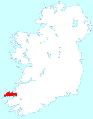
The Dingle Peninsula is the northernmost of the major peninsulas in County Kerry. It ends beyond the town of Dingle at Dunmore Head, the westernmost point of Ireland.

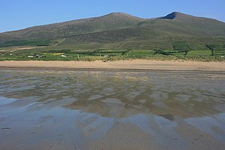
Mount Brandon or Brandon, at 952 metres (3,123 ft), is one of the ten highest peaks in Ireland, being the 8th–highest peak in Ireland on the Arderin list, and the 9th–highest on the Vandeleur-Lynam list. Brandon is the highest Irish mountain outside the MacGillycuddy's Reeks range and has the greatest prominence of any Irish peak except Carrauntoohil, Ireland's highest mountain.

In physical geography, a dell is a grassy hollow—or dried stream bed—often partially covered in trees. In literature, dells have pastoral connotations, frequently imagined as secluded and pleasant safe havens.

A mudflow, also known as mudslide or mud flow, is a form of mass wasting involving fast-moving flow of debris and dirt that has become liquified by the addition of water. Such flows can move at speeds ranging from 3 meters/minute to 5 meters/second. Mudflows contain a significant proportion of clay, which makes them more fluid than debris flows, allowing them to travel farther and across lower slope angles. Both types of flow are generally mixtures of particles with a wide range of sizes, which typically become sorted by size upon deposition.
The Dingling were an ancient people who appear in Chinese historiography in the context of the 1st century BCE.

Snow Hill Island is an almost completely snowcapped island, 33 km (21 mi) long and 12 km (7.5 mi) wide, lying off the east coast of the Antarctic Peninsula. It is separated from James Ross Island to the north-east by Admiralty Sound and from Seymour Island to the north by Picnic Passage. It is one of several islands around the peninsula known as Graham Land, which is closer to Chile, Argentina and South America than any other part of the Antarctic continent.
The Mountains of the Central Dingle Peninsula are the generic name given to the mountains that lie on the Dingle Peninsula between the Brandon Group of mountains in the west, and the Slieve Mish Mountains at the eastern end of the peninsula.
Slieve Mish Mountains, is a predominantly sandstone mountain range at the eastern end of the Dingle Peninsula in County Kerry, Ireland. Stretching 19 kilometres, from the first major peak of Barnanageehy outside of Tralee in the east, to Cnoc na Stuaice in near Central Dingle in the west, the range has over 17 material peaks, with the core of the mountain range based around the massif of its highest peak, Baurtregaum, and its deep glacial valleys of Derrymore Glen and Curraheen Glen.

Maryland Route 49 is a state highway located in Allegany County in the U.S. state of Maryland. Known as Braddock Road, the state highway runs 2.7 miles (4.3 km) from MD 658 in La Vale east to Greene Street in Cumberland. MD 49 is maintained by the Maryland State Highway Administration (MDSHA) for 1.02 miles (1.64 km) on the west side of Haystack Mountain. The 1.7-mile (2.7 km) eastern segment, which is maintained by the city of Cumberland, is not recognized as part of the state highway by MDSHA but is signed as MD 49. Braddock Road was cleared as a military trail in the 1750s and was part of the National Road in the early 19th century. The modern MD 49 was constructed in the 1920s. The state highway originally extended west to MD 53 just south of U.S. Route 40, but the highway was physically truncated by the construction of Interstate 68 (I-68) in the early 1970s. The eastern part of MD 49 was transferred to Cumberland in the early 1990s.

Caherconree at 835 metres (2,740 ft), is the 20th–highest peak in Ireland on the Arderin scale, and the 27th–highest peak on the Vandeleur-Lynam scale. Caherconree is the 2nd-highest mountain in the Slieve Mish Mountains in the Dingle Peninsula in County Kerry, Ireland, and one of its southerly spurs is the site of an ancient stone promontory fort, which is a protected National Monument.

Bear Lake National Wildlife Refuge is located in southeast Idaho, seven miles (11 km) south of Montpelier. Surrounded by mountains, it lies in Bear Lake Valley at an elevation ranging from 5,925 feet (1,806 m) on the marsh to 6,800 feet (2,100 m) on the rocky slopes of Merkley Mountain. The refuge office is located in Montpelier.

Carhoo Hill or Ballymacadoyle Hill is a large hill south-west of Dingle in County Kerry, Ireland.

Mount Eagle is a mountain in County Kerry, Ireland.
Mount Pisgah is a mountain located in the Catskill Mountains of New York southeast of Bovina Center. Grays Mountain, Fords Hill, and Dingle Hill are located south of Mount Pisgah.
Grays Mountain is a mountain located in the Catskill Mountains of New York southeast of Bovina Center. Grays Mountain is located south of Mount Pisgah, southwest of Farmers Hill, west-northwest of Fords Hill and north of Dingle Hill.
Meekers Hill is a mountain located in the Catskill Mountains of New York southeast of Andes. Dingle Hill is located northwest, and Fords Hill is located northwest of Meekers Hill.
Red Hill is a mountain located in the Catskill Mountains of New York east-south of Frost Valley. Woodhull Mountain is located northeast of Red Hill.
Gallis Hill is a 794-foot-tall (242 m) mountain in the Catskill Mountains region of New York. It is located northwest of Kingston in Ulster County. Jockey Hill is located north-northeast, and Morgan Hill is located west of Gallis Hill. In 1927, the Conservation Department built a steel fire lookout tower on the mountain. In 1950, the tower was closed and disassembled then moved to Overlook Mountain, where it still remains today.

