Disputed territories of India

Last updated

Map showing disputed territories of India India disputed areas map.svg
Map showing disputed territories of India

There are several disputed territories of India. A territorial dispute is a disagreement over the possession or control of land between two or more states or over the possession or control of land by a new state and occupying power after it has conquered the land from a former state no longer currently recognized by the new state.

Contents

India faces territorial issues with some of its neighbours – the People's Republic of China, Pakistan and Nepal. [1] The dispute with China also involves the Republic of China based in Taiwan. [2] India has resolved its un-demarcated border with Bhutan, which included multiple irregularities. India also resolved its border disputes with Bangladesh and Sri Lanka.
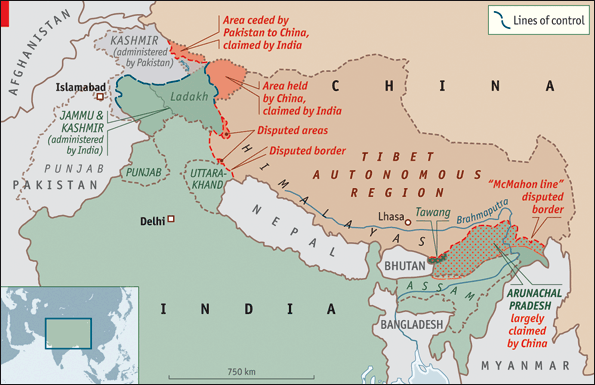
Current disputes

China

Sino-Indian border

Two governments claim to be the legitimate Chinese government, the People's Republic of China (PRC) and the Republic of China (ROC; commonly called "Taiwan"). They do not recognise the legitimacy of each other. The PRC has actual control of their areas on the India-China border, while the ROC currently has no shared land or maritime border with India. Their views are presented below. The Line of Actual Control (LAC) is presently the operational border between India and the PRC.

People's Republic of China's position

The Depsang Plains are located on the border of the Indian union territory of Ladakh and the disputed zone of Aksai Chin. The Chinese Army controls most of the plains, [3] while India controls the western portion of the plains. [4] The dispute remains unresolved. [5]

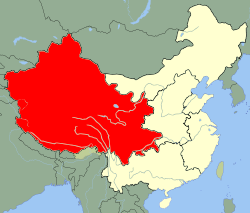
Arunachal Pradesh is a state of India created on 20 January 1972, located in the far northeast. It borders the states of Assam and Nagaland to the south, and shares international borders with Burma in the east, Bhutan in the west, and China in the north. The majority of the territory is claimed by China, by whom it is called South Tibet. The northern border of Arunachal Pradesh reflects the McMahon Line, a line demarcated by the 1914 Simla Convention between the United Kingdom and the Tibetan government. The Simla Convention was never accepted by the Chinese government, and it was also considered invalid by Tibetans due to unmet conditions specified in the treaty. [6] The boundary was not broadly enforced by the Indian government until 1950. Currently, this territory is administered by India. [7] [8]

Republic of China's position

Throughout the Cold War, the Government of the Republic of China had the same understanding on the China-India border dispute as the PRC. [2] In 1962, the ROC's Ministry of Foreign Affairs stated that they did not recognise the legality of the McMahon Line. The same year western countries increased pressure on ROC leader Chiang Kai-shek to recognise the legality of the McMahon Line in order to isolate Beijing. [2] However, Chiang dismissed the McMahon Line as an 'imperialist imposition on China'. In February 1987, India's move to elevate the status of 'Arunachal centrally administered region' to the state of Arunachal Pradesh was declared null and void by the ROC's Ministry of Foreign Affairs. [2] The Ministry, in a formal statement, stated that it did not recognise the 'illegal occupation' of ROC territory south of the McMahon Line and that the establishment of 'Arunachal Pradesh state' was an illegal act. In 1995, Ambassador Teng Pei-Yin (the ROC's first representative to India) in response to an Indian member of parliament, stated that the ROC did not recognise the McMahon Line. [2] However, the ROC has not made any statement on the China-India dispute since. [2]

Disputed areas

China's integrated Western Theater Command area. Map of Western Theatre of PLA.svg
China's integrated Western Theater Command area.

The Chinese Military has an integrated Western Theater Command across the entire border with India. [9] The Indian Military has divided the Line of Actual Control into 3 sectors - the western sector across Ladakh and the Chinese-held Aksai Chin, the central sector across Himachal Pradesh and Uttarakhand, and the eastern sector across Sikkim and Arunachal Pradesh. [10] Similarly, the Indian Airforce has a New Delhi-based Western Air Command, a Prayagraj-based Central Air Command, and a Shillong-based Eastern Air Command with several AFS (Air Force Stations/Bases), AGL (Advanced Landing Ground airports) and helipads to cover the LAC.

List of disputed areas from west to east along the India-China border: [11]

Disputed areaAdministrativeControlled byAirbases / AGLsComments / Geostrategic context
IndiaChinaIndiaChina
Trans-Karakoram Tract (Shaksgam) Ladakh (Leh district) Xinjiang China (since 1963) Daulat Beg Oldi Ceded to China in 1963 by Pakistan subject to the resolution of Kashmir dispute with India. [11] Ref: [12] [13] [14] [15]
Aksai Chin Ladakh (Leh district)XinjiangChinaDaulat Beg Oldi AGL, Leh Airport Ref: [16] [11]
Demchok sector Ladakh (Leh district) Tibet (Ngari Prefecture)India and China south and north of the Indus River respectively. Fukche [16] Ref: [11]
Chumar (2 separate noncontiguous Chumur North & Chumur South subsectors)Ladakh (Leh district)TibetIndia Nyoma, [16] Padum AGL, [16] helipad at Chumur.Ref: [11]
Kaurik Himachal Pradesh (Lahaul and Spiti district) [11] TibetIndia Chinyalisaur Airport AGL, Pathankot Airport Ref: [11]
Tashigang-Shipki La Himachal Pradesh (Kinnaur district)TibetIndiaChinyalisaur AGL, Pathankot AirportShipki La, with Indian military post, is an important pass for trade.
Ref: [11] [17]
Sang-Nelang-Pulam Sumda Uttarakhand (Uttarkashi district)TibetIndiaChinyalisaur AGL, Pathankot AirportArea also covers Jadhang villages. Ref: [11]
Barahoti Uttarakhand (Chamoli district)TibetIndia [11] Chinyalisaur AGL, Pithoragarh Airport AGLArea also covers Silakang Lapthal Sangcha Malla villages. [11]
Ref: [11]
Arunachal Pradesh Arunachal PradeshTibetIndia Tawang AFS & 7 AGLs [18] (Aalo, Mechuka, Pasighat, Tuting, Vijoynagar, Walong, Ziro)Most of the state is claimed by China. [11]
Ref: [11]

Within the geostrategic context of disputes between India and China, the disputes over Doklam and the Ten Degree Channel and South China Sea shipping lane are also relevant. Doklam is a dispute between Bhutan and China near the India-Bhutan-China tri-junction. India has sided with Bhutan in the dispute. [19] [20] The area is of strategic importance to all three countries. [21] Doklam lies close to India's Siliguri "Chickenneck" Corridor where a Chinese military advance of less than 130 kilometres (81 mi) would cut off Bhutan, part of West Bengal and all of Northeast India, an area containing almost 50 million people. This scenario arose during the war between India and China in 1962. [22] [17] India has embarked on a slew of Northeastern India connectivity projects to create multiple alternatives to the Silliguri corridor, including through Bangladesh, National Waterways and seaports, to mitigate the risk of being cut off.

The world's busiest Sea line of communication (SLOC) passes through the Strait of Malacca and the Ten Degree Channel in the exclusive economic zone of India, a region protected by India's Andaman and Nicobar Command. It is a geostrategic choke point for China since over 94,000 merchant ships travel through every year, carrying 40% of the world's freight trade between China and other nations. [23] US$5 trillion in annual shipping trade passes through the SLOC and choke points of Southeast Asia and the South China Sea (SCS). [24] [25] 80% of global trade passes through the Indian Ocean SLOC in the form of oil and natural gas critical for advanced economies. [25] India, Australia, Japan and the United States have comprised the Quadrilateral Security Dialogue (QUAD) to contain China as part of their Indo-Pacific strategy. [26] [27] [28] [29]

Pakistan

Kashmir

The divisions of the disputed Kashmir region administered by the republics of Pakistan, India, and China Kashmir map.svg
The divisions of the disputed Kashmir region administered by the republics of Pakistan, India, and China

The conflict over Kashmir is primarily between India and Pakistan, with China largely playing a third-party role. [30] [31] Conflict started after the partition of India in 1947, as both India and Pakistan initially claimed the entirety of the former princely state of Jammu and Kashmir. In 1963, Pakistan recognized Chinese sovereignty over the Trans-Karakoram Tract and Aksai Chin. [13] India controls 70% of Kashmir's population and approximately 55% of its land area including Jammu, Kashmir Valley, most of Ladakh, and Siachen Glacier. [32] Pakistan controls approximately 30% of the land including Azad Kashmir and Gilgit-Baltistan. China controls the remaining 15% of the land, including Aksai Chin and the mostly uninhabited Trans-Karakoram Tract, as well as part of the Demchok sector. [33] [34] [35] [36] [37] [38]

Sir Creek

Sir Creek is a 96 km (60 mi) tidal estuary in the uninhabited marshlands of the Indus River Delta on the border between India and Pakistan. It flows into the Arabian Sea and separates Gujarat state in India from Sindh province in Pakistan. [39] The long-standing India-Pakistan Sir Creek border dispute stems from the demarcation "from the mouth of Sir Creek to the top of Sir Creek, and from the top of Sir Creek eastward to a point on the line designated on the Western Terminus". [39] [40] From this point onward, the boundary is unambiguously fixed as defined by the Tribunal Award of 1968. [41]

Junagadh and Manavadar

In a new political map released in 2020, Pakistan claimed the former princely states of Junagadh and Manavadar. [42] [43] [44]

Nepal

Major areas of dispute between India and Nepal are Kalapani, Limpiyadhura, Lipulekh, Susta, Mechi, and Tanakpur. [45] An estimated 60,000 hectares of border land is currently disputed between India and Nepal. [46]

Kalapani territory

Although claimed by Nepal, Kalapani has been administered by Indian army since the 1962 border war with China and Indian maps have been showing Kalapani as part of India since then. [45] The 1816 Treaty of Sugauli signed by Kingdom of Nepal and British India in 1816 utilizes the Kali River as Nepal's western boundary with India. However, lack of consensus on what is the precise location of the river Kali has resulted in dispute over whether the land consisting Kalapani, Limpiyadhura and Lipulekh is part of India or Nepal. [47] Some scholars suggest that the lack of consensus is because of British cartographers who kept on shifting the line demarcating the river eastwards for strategic reasons. However, there are also some scholars who believe that lack of consensus is due to the shift in the course of the river over time. [47]

In November 2019, India issued a new political map of the country which, like earlier maps, showed Kalapani as part of India. This new map was rejected by Nepal, and mass protest against India took place across the country and outside the Indian embassy in Nepal. Protesters accused India of occupying their land. [48] In May 2020, the Indian Defence minister, Rajnath Singh inaugurated an 80 km road from Dharchula to Lipulekh pass. Nepal protested against the construction of the road. [49] The Lipulekh area is currently under India's control. On 20 May 2020, Nepal launched its own map showing Kalapani, Limpiyadhura and Lipulekh as parts of its own territory. [50] The new map was subsequently approved by the Nepali parliament on 18 June 2020. India opposed the move, claiming that the decision to include Limpiyadhura, Lipulekh and Kalapani is not based on evidence or historical facts. [51]

On 15 June 2020, the Indian border police, Sashastra Seema Bal (SSB), reported that border pillars which served as demarcation were missing along the India-Nepal border. SSB also reported that Nepali border police had established five new border outposts near the disputed area. [52] On 19 June, Nepal started deploying troops near the disputed areas. The troops had established camps and they were working on building a helipad in the area. [53] In the same month Nepali Army Chief, General Purna Chandra Thapa, after visiting the Kalapani border area, stated that the Nepali Army will start building army barracks and border outposts near the Kalapani area. [54] On 21 June, Indian residents in border villages of Dharchula and Jhoolaghat in Pithoragarh district claimed that radio stations in Nepal were conducting a propaganda campaign against India by playing anti-India songs and biased news bulletins showing India in a bad light. [55]

Susta territory

Susta is another territory which is disputed between Nepal and India. It is currently controlled by India as a part of Bihar state. Media reported residents of a village in Susta claiming that Susta belongs to Nepal and they are Nepali citizens. [56] The 1816 Treaty of Sugauli defined Gandaki river as the international boundary between India and Nepal. The right bank of the river was under Nepal's control while the left bank was under India's control. Susta village was initially on the right bank when the treaty was signed and it was a part of Nepal. However, over the years, the Gandaki river changed its course and Susta moved to the left bank and is now currently under India's control. [56] The Government of Nepal has repeatedly stated that Susta belongs to Nepal and that the Indian government should return the area.

Resolved disputes

Sri Lanka

The dispute on the status of the island of Kachatheevu was settled in 1974 by an agreement between both countries. [57] But still some cases are ongoing in High Court of Madras which are filed earlier regarding this dispute stating as illegally issued to Sri Lanka. [58] Several actions were still taken by the union government of India to retrieve that island back to Indian territory once again. [59]

Bangladesh

South Talpatti (as it was known internationally) or Sheikh Mujib Island (as it was known by Bangladeshi Awami League supporters) was a small uninhabited offshore sandbar landform in the Bay of Bengal, off the coast of the Ganga-Brahmaputra Delta region. In the aftermath of the Bhola cyclone in 1970, it emerged in the Bay of Bengal on the Bangladeshi side of the dividing river, and disappeared before or during Cyclone Aila in 2009. In March 2010, Sugata Hazra of the School of Oceanographic Studies at Jadavpur University, Kolkata, said that the island had disappeared and that sea level rise caused by climate change was a factor. [60]

The enclaves were reputedly part of a high stake card or chess games centuries ago between two regional kings, the Maharaja of Cooch Behar and the Nawab of Rangpur and the result of a confused outcome of a treaty between the Kingdom of Cooch Behar and the Mughal Empire. After the partition of India in 1947, Cooch Behar district joined India and Rangpur went to East Pakistan, which became Bangladesh in 1971. The prime ministers of India and Bangladesh signed a Land Boundary Agreement in 1974 to exchange enclaves and simplify the international border. In 1974 Bangladesh approved a proposed treaty to exchange all enclaves within each other's territories, but India did not ratify it. Another agreement was made in 2011 to exchange enclaves and adverse possessions. A revised version of the agreement was finally adopted by the two countries 41 years after negotiations began, when the Parliament of India passed the 100th Amendment Act to the Indian Constitution on May 7, 2015. [61] Inside the main part of Bangladesh, there were 111 Indian enclaves (17,160.63 acres), while in the main part of India, there were 51 Bangladeshi enclaves (7,110.02 acres). In respect of adverse possessions, India received 2,777.038 acres of land and transferred 2267.682 acres to Bangladesh. India ratified the agreement by constitutional amendment in May 2015. [62] Under this agreement, the enclave residents could continue to reside at their present location or move to the country of their choice. [63] [64] The adverse possession of Berubari went to Bangladesh. [65] The unmarked borders between the nations were also finally solved regarding Daikhata-Dumabari, Muhurichar river island [66] and Pyrdiwah. [67]

In 2009 Bangladesh initiated arbitration proceedings against India under the United Nations Convention on Law of Sea. In 2014 it was awarded a large part of the Bay of Bengal, ending the maritime dispute between the two countries. [68]

See also

Related Research Articles

<span class="mw-page-title-main">Foreign relations of Nepal</span>

Though the Ministry of Foreign Affairs (MOFA) is the government agency which is responsible for conducting the foreign relations of Nepal, historically, it is the Office of Prime Minister (PMO) which has exercised the authority to formulate the country's foreign policies. As a landlocked country wedged between two larger and far stronger powers, Nepal has tried to maintain good relations with both of its neighbors, People's Republic of China and Republic of India. However, the relationship between Nepal and India was significantly hampered by the 2015 Nepal blockade when the Government of Nepal accused India of mimicking "Russia-Ukraine" tactics by using ethnically Indian residents of Nepal to cause unrest along Nepal's southern border. India denied the allegation and said the unrest were an internal affair. For the most part though, Nepal has traditionally maintained a non-aligned policy and enjoys friendly relations with its neighboring countries and almost all the major countries of the world.

<span class="mw-page-title-main">Aksai Chin</span> Region in Xinjiang, Tibet, and Kashmir administered by China

Aksai Chin is a region administered by China partly in Hotan County, Hotan Prefecture, Xinjiang and partly in Rutog County, Ngari Prefecture, Tibet and constituting the easternmost portion of the larger Kashmir region that has been the subject of a dispute between India and China since 1959. It is claimed by India as part of its Leh District, Ladakh Union Territory.

<span class="mw-page-title-main">Line of Actual Control</span> Disputed boundary between China and India

The Line of Actual Control (LAC), in the context of the Sino-Indian border dispute, is a notional demarcation line that separates Indian-controlled territory from Chinese-controlled territory. The concept was introduced by Chinese premier Zhou Enlai in a 1959 letter to Jawaharlal Nehru as the "line up to which each side exercises actual control", but rejected by Nehru as being incoherent. Subsequently, the term came to refer to the line formed after the 1962 Sino-Indian War.

<span class="mw-page-title-main">Leh district</span> District of Ladakh, administered by India

Leh district is a district in Indian-administered Ladakh in the disputed Kashmir-region. Ladakh is an Indian-administered union territory. With an area of 45,110 km2, it is the second largest district in the country, second only to Kutch. It is bounded on the north by Gilgit-Baltistan's Kharmang and Ghanche districts and Xinjiang's Kashgar Prefecture and Hotan Prefecture, to which it connects via the historic Karakoram Pass. Aksai Chin and Tibet are to the east, Kargil district to the west, and Lahul and Spiti to the south. The district headquarters is in Leh. It lies between 32 and 36 degree north latitude and 75 to 80 degree east longitude.

<span class="mw-page-title-main">Sino-Indian border dispute</span> Border dispute between China and India

The Sino–Indian border dispute is an ongoing territorial dispute over the sovereignty of two relatively large, and several smaller, separated pieces of territory between China and India. The first of the territories, Aksai Chin, is administered by China and claimed by India; it is mostly uninhabited high-altitude wasteland but with some significant pasture lands at the margins. It lies at the intersection of Kashmir, Tibet and Xinjiang, and is crossed by China's Xinjiang-Tibet Highway; the other disputed territory is south of the McMahon Line, in the area formerly known as the North-East Frontier Agency and now a state called Arunachal Pradesh. It is administered by India and claimed by China. The McMahon Line was signed between British India and Tibet to form part of the 1914 Simla Convention, but the latter was never ratified by China. China disowns the McMahon Line agreement, stating that Tibet was not independent when it signed the Simla Convention.

<span class="mw-page-title-main">India–Nepal relations</span> Bilateral relations

India–Nepal relations are the bilateral relations between the Republic of India and the Federal Democratic Republic of Nepal. Both countries initiated their relationship with the 1950 Indo-Nepal Treaty of Peace and Friendship and accompanying secret letters that defined security relations between the two countries, and an agreement governing both bilateral trade and trade transiting Indian territory.

The Sino-Pakistan Agreement is a 1963 document between the governments of Pakistan and China establishing the border between those countries in the disputed Kashmir region.

The Kalapani territory is an area under Indian administration as part of Pithoragarh district in the Kumaon Division of the Uttarakhand state, but it is also claimed by Nepal since 1997. According to Nepal's claim, it lies in Darchula district, Sudurpashchim Province. The territory represents part of the basin of the Kalapani river, one of the headwaters of the Kali River in the Himalayas at an altitude of 3600–5200 meters. The valley of Kalapani, with the Lipulekh Pass at the top, forms the Indian route to Kailash–Manasarovar, an ancient pilgrimage site. It is also the traditional trading route to Tibet for the Bhotiyas of Kumaon and the Tinkar valley of Nepal.

The Republic of India shares borders with several sovereign countries; it shares land borders with China, Bhutan, Nepal, Pakistan, Bangladesh, and Myanmar. Bangladesh, Myanmar, and Pakistan share both land borders as well as maritime borders, while Sri Lanka shares only a maritime border through Ram Setu. India's Andaman and Nicobar Islands share a maritime border with Thailand, Myanmar, and Indonesia.

<span class="mw-page-title-main">Border Personnel Meeting Point</span> India/China army consultation locations

Border Personnel Meeting points are locations along the disputed Sino-Indian territories on Line of Actual Control (LAC) where the armies of both countries hold ceremonial and practical meetings to resolve border issues and improve relations. While border meetings have been held since the 1990s, the first formal Border Personnel Meeting point was established in 2013. There are five meeting points: two in the Indian Union Territory of Ladakh, one in Sikkim, and two in Arunachal Pradesh in India's Central and Eastern sectors.

<span class="mw-page-title-main">India–Nepal border</span> International boundary in South Asia

The India–Nepal border is an open international boundary running between the republics of India and Nepal. The 1,850 km (1,149.54 mi) long border includes the Himalayan territories as well as Indo-Gangetic Plain of the subcontinent. The current border was delimited after the Sugauli treaty of 1816 between Nepal and the British Raj. Following Indian independence, the prevailing border was recognised as the international border between the Kingdom of Nepal and the Dominion of India.

Tinkar is a village in the Byans Rural Municipality of Darchula District in the Sudurpashchim province of Nepal. It is named after the Tinkar Khola river, a tributary of the Mahakali River, which it joins near the village of Chhangru.

<span class="mw-page-title-main">Susta territory</span> Disputed territory

Susta is a disputed territory between Nepal and India. It is administered by India as part of West Champaran district of Bihar. It is claimed by Nepal as part of Susta rural municipality, under West Nawalparasi District in Lumbini Province. The disputed territory is located on the eastern side of the Gandak river. Nepal claims the area a part of West Nawalparasi District under Susta rural municipality, alleging that over 14,860 hectares of Nepali land in Susta has been encroached upon by India while India claims "Susta" to be a part of West Champaran district.

The Constitution of Nepal Act provided the legal status to a new map of Nepal to be used in the country's national emblem by amending Schedule 3 in the Constitution of Nepal. The Council of Ministers of Nepal had announced the new map on 20 May 2020 and two days later it was placed in the Parliament. On 13 June 2020, the motion was put forth for voting in the lower house of Nepal's Parliament by the government of Prime Minister KP Sharma Oli. Voting was unanimous with ayes being 258 with no nays. On 18 June 2020, the Upper House unanimously passed the Bill after which the President of Nepal Bidhya Devi Bhandari signed the Bill.

The Five Fingers of Tibet was a Chinese territorial claim to the Himalayan region bordering India attributed to Mao Zedong. It considers Tibet to be China's right hand palm, with five fingers on its periphery: Ladakh, Nepal, Sikkim, Bhutan, and North-East Frontier Agency that are considered China's responsibility to "liberate". The policy however has never been discussed in official Chinese public statements and is now dormant, but concerns have often been raised over its possible continued existence or revival.

<span class="mw-page-title-main">Chinese irredentism</span> Irredentist claims to territories of the former Chinese Empire

Chinese irredentism involves irredentist claims to the territories of former Chinese dynasties made by the Republic of China (ROC) and subsequently the People's Republic of China (PRC).

Border infrastructure along the Sino-Indian border, which has several border areas disputed by both India and China, encompasses irrigation, roads, railways, airports, natural gas and oil pipelines, electricity grids, telecommunications, and broadcasting. In the context of the border tensions between India and China, many of these infrastructure projects in the borderlands are considered strategic in nature. Commentators have noted the infrastructure gap that existed, and still exists, between the infrastructure on the borderlands of India and China. For many decades, the approach taken to the construction of border infrastructure by China and India was significantly different, however, in terms of utilizing the natural resources of the borderlands for the needs of the country, both countries are said to have a similar approach.

<span class="mw-page-title-main">Territorial disputes of the People's Republic of China</span>

This article is about territorial disputes of the People's Republic of China (PRC). A territorial dispute is a disagreement over the possession or control of land between two or more political entities. Many of these territorial disputes are almost identical to those that the Republic of China (ROC) based in Taipei, also known as Taiwan, has with other countries. Therefore, many of the subsequent resolved disputes made by the PRC after 1949 with other governments may not be recognized by the ROC.

References

  1. Vaid, Darvi (10 May 2020). "New road rouses territorial dispute between India and Nepal". DW.com.
  2. 1 2 3 4 5 6 P. Panda, Jagannath (8 April 2019). India and China in Asia: Between Equilibrium and Equations. Routledge. ISBN   9780429755163.
  3. Manoj Joshi (2013-05-07). "Making sense of the Depsang incursion". The Hindu. Retrieved 2014-03-15.
  4. "Khurshid to visit China on May 9, no date for flag meet". Hindustan Times. 2013-04-25. Archived from the original on April 25, 2013. Retrieved 2014-03-15.
  5. "Let's shake hands: 20 days on, China withdraws troops from Ladakh : India, News - India Today". Indiatoday.intoday.in. 2013-05-05. Retrieved 2014-03-15.
  6. Tsering Shakya (1999). The Dragon in the Land of Snows: A History of Modern Tibet Since 1947. Columbia University Press. pp. 279–. ISBN   978-0-231-11814-9.
  7. Guo, Rongxing (2006). Territorial Disputes and Resource Management: A Global Handbook. Nova Publishers. p. 51. ISBN   9781600214455.
  8. Shurtleff, William; Aoyagi, Akiko (2010). History of Soybeans and Soyfoods in South Asia / Indian Subcontinent (1656-2010): Extensively Annotated Bibliography and Sourcebook (illustrated ed.). Soyinfo Center. p. 952. ISBN   9781928914310.
  9. "Eye on India, China raises Tibet military command rank | Central Tibetan Administration". tibet.net. Archived from the original on 2016-11-07. Retrieved 2016-10-01.
  10. "Twisting India's Chicken's Neck". lowyinstitute.org. Retrieved 2020-07-18.
  11. 1 2 3 4 5 6 7 8 9 10 11 12 13 14 "India's border dispute with neighbors". aa.com.tr. Retrieved 2020-07-18.
  12. "Facing the truth". 20 October 2006. The Shaksgam Valley was never part of Kashmir and the northern and eastern boundaries of Kashmir were undefined
  13. 1 2 "Signing with the Red Chinese". Time (magazine). 15 March 1963. Archived from the original on December 22, 2008. Retrieved 28 October 2019.
  14. R Chandrashekhar (2017). THE GILGIT AND BALTISTAN REGIONS OF JAMMU AND KASHMIR STATE (PDF). New Delhi: Xtreme Office Aids Pvt. Ltd. p. 63. ISBN   978-93-84492-36-6.{{cite book}}: |website= ignored (help)[ permanent dead link ]
  15. Complete Atlas Of The World (3 ed.). Penguin Random House. 2016. p.  238 via Internet Archive. (claimed by India)
  16. 1 2 3 4 India plans AGL strips, Deccan Herald, 2014.
  17. 1 2 "Believe It Or Not, China Has Been Grabbing Land For Forty Years, Say Ladakh Residents". outlookindia.com. Retrieved 2020-07-18.
  18. IAF to have seven AGL in Arunachal Pradesh, Economic Times, 2018.
  19. Banyan (27 July 2017), "A Himalayan spat between China and India evokes memories of war", The Economist, archived from the original on 8 August 2017
  20. "Translation of the Proceedings and Resolutions of the 82nd Session of the National Assembly Of Bhutan" (PDF). June–August 2004. p. 84. Archived (PDF) from the original on 7 October 2015. Retrieved 20 July 2017.
  21. "People say in Doklam, India is better placed. Why do we think Chinese could only act here? says Shyam Saran", The Indian Express, 12 August 2017, archived from the original on 13 August 2017
  22. Partha S. Ghosh, "Cooperation and Conflict in South Asia", UPL, Dhaka, 1989, p-43
  23. The Growing Strategic Importance of the Andaman and Nicobar Islands Archived 2020-07-06 at the Wayback Machine , Future Directions org, 15 JUNE 2017.
  24. More muscle for India’s Andaman and Nicobar defence posts to counter hawkish China, Hindustan Times, 26 Aug 2017.
  25. 1 2 Australia’s own Indo-Pacific fortress – The case for redeveloping Cocos Islands, Defence Connect, 28 MAY 2019.
  26. Griffiths, James. "A border dispute with China may push India closer to some of Beijing's top rivals". CNN. Retrieved 2020-06-18.
  27. Chellaney, Brahma. "Different playbooks aimed at balancing Asia’s powers". The Japan Times , 3 November 2008 (originally published by the BBC Monitoring South Asia).
  28. Ching, Frank. "Asian Arc of Democracy"
  29. Twining, Daniel. "The new Asian order’s challenge to China". Financial Times , 26 September 2007.
  30. Yahuda, Michael (2 June 2002). "China and the Kashmir crisis". BBC. Retrieved 22 March 2019.
  31. Chang, I-wei Jennifer (9 February 2017). "China's Kashmir Policies and Crisis Management in South Asia". United States Institute of Peace. Retrieved 22 March 2019.
  32. Malik, V. P. (2010). Kargil from Surprise to Victory (paperback ed.). HarperCollins Publishers India. p. 54. ISBN   9789350293133.
  33. "Kashmir: region, Indian subcontinent". Encyclopædia Britannica. Retrieved 16 July 2016.
  34. "Jammu & Kashmir". European Foundation for South Asian Studies. Retrieved 4 May 2020.
  35. Snow, Shawn (19 September 2016). "Analysis: Why Kashmir Matters". The Diplomat . Retrieved 4 May 2020.
  36. Hobbs, Joseph J. (13 March 2008). World Regional Geography. CengageBrain. p. 314. ISBN   978-0495389507.
  37. Ie Ess Wor Reg Geog W/Cd. Thomson Learning EMEA. 2002. ISBN   9780534168100. India now holds about 55% of the old state of Kashmir, Pakistan 30%, and China 15%.
  38. Margolis, Eric (2004). War at the Top of the World: The Struggle for Afghanistan, Kashmir and Tibet (paperback ed.). Routledge. p. 56. ISBN   9781135955595.
  39. 1 2 "The troubled waters of Sir Creek: Gujarat CM's demand for a freeze on the disputed creek complicates issue, dated 16 December 2012". India Today. Retrieved 29 Dec 2019.
  40. "Pakistan security experts declare Sir Creek dispute 'technically resolved'". dna. 7 September 2013.
  41. "Kargilisation of Sir Creek". The Tribune, Chandigarh. Retrieved May 21, 2006.
  42. "Why Pakistan has claimed Junagadh in its new political map". India Today. 7 August 2020. Retrieved 27 May 2021.
  43. "Pakistan unveils new political map of country; shows Junagarh, Manavdar and Sir Creek areas of Gujarat as Pakistani territory". DeshGujarat. 4 August 2020. Retrieved 27 May 2021.
  44. "After Nepal, Pakistan unveils new political map; Jammu & Kashmir and Ladakh claimed, India retorts". The Himalayan Times. 4 August 2020. Retrieved 27 May 2021.
  45. 1 2 "India and Nepal's Slow-Motion Border Dispute". The Diplomat. 4 January 2020.
  46. "As a river changed its course, a village on the India-Nepal border became disputed territory". Scroll.in. 19 March 2017.
  47. 1 2 "Mapping the history of Kalapani dispute between India and Nepal". Indian Express. 13 June 2020.
  48. "India's updated political map stirs controversy in Nepal". Al Jazeera. 8 November 2019.
  49. "Nepal summons Indian envoy to protest opening of road to Lipulekh". Hindustan Times. 11 May 2020.
  50. Bhattacherjee, Kallol (20 May 2020). "Nepal's new political map claims India's territories" via www.thehindu.com.
  51. "Nepal Parliament approves new map that includes land India claims". Al Jazeera. 18 June 2020.
  52. "India-Nepal border posts missing: SSB". Times of India. 15 June 2020.
  53. "In a first, Nepal deploys its troops at border with India". India Today. 19 June 2020.
  54. "Nepal to set up army barrack, border outpost near Kalapani after getting controversial new map". theprint.in. 19 June 2020.
  55. "Nepal stations bombard Uttarakhand villages with anti-India". Times of India. 21 June 2020.
  56. 1 2 "As a river changed its course, a village on the India-Nepal border became disputed territory". scroll.in. 19 March 2017.
  57. "Kachchatheevu was not ceded to Sri Lanka, Centre tells court". The Hindu. 2013-08-31. ISSN   0971-751X . Retrieved 2021-09-26.
  58. Correspondent, Legal (2018-08-22). "HC wants to know status of case filed by Jayalalithaa to retrieve Katchatheevu". The Hindu. ISSN   0971-751X . Retrieved 2021-05-31.
  59. "Centre making sincere efforts to retrieve Katchatheevu: V.K. Singh". The Hindu. 2021-02-08. ISSN   0971-751X . Retrieved 2022-04-16.
  60. Wade, Matt (March 25, 2010). "Rising sea level settles border dispute". The Sydney Morning Herald. Retrieved April 4, 2010.
  61. "The Constitution (119th Amendment) Bill, 2013" PRS India. Accessed 10 May 2015.
  62. India (2 December 2014). "Everything you need to know: Land swap in offing with Bangladesh to end disputes". The Indian Express. Retrieved 29 May 2015.
  63. Sougata Mukhopadhyay (7 September 2011). "India-Bangladesh sign pact on border demarcation". CNN-IBN. Archived from the original on 22 June 2012. Retrieved 2011-09-20.
  64. Special Correspondent (2015-05-07). "Parliament passes historic land accord bill to redraw border with Bangladesh". The Times Of India. Retrieved 2015-05-07.
  65. MANOJ ANAND (2015-05-08). "Bangladesh land swap deal: AGP calls bandh, says PM Modi betrayed people". The Asian Age. Retrieved 2015-05-08.
  66. Shubhajit Roy (2014-12-02). "Everything you need to know: Land swap in offing with Bangladesh to end disputes". Indian Express. Retrieved 2014-12-02.
  67. Special correspondent (2015-05-06). "Meghalaya groups flay land-swap deal". Calcutta Telegraph. Archived from the original on May 7, 2015. Retrieved 2014-05-06.
  68. "Bangladesh wins maritime dispute with India". The Hindu. 2014-07-09. ISSN   0971-751X . Retrieved 2024-06-14.