
Alameda County is a county located in the U.S. state of California. As of the 2020 census, the population was 1,682,353, making it the 7th-most populous county in the state and 21st most populous nationally. The county seat is Oakland. Alameda County is in the San Francisco Bay Area, occupying much of the East Bay region.

The East Bay Regional Park District (EBRPD) is a special district operating in Alameda County and Contra Costa County, California, within the East Bay area of the San Francisco Bay Area. It maintains and operates a system of regional parks which is the largest urban regional park district in the United States. The administrative office is located in Oakland.
Canyon, formerly known as Sequoya, is an unincorporated community located near the border of Contra Costa and Alameda counties, in the U.S. state of California. It is situated between Oakland and Moraga in the San Francisco Bay Area. The community is named for its location in the upper canyon of San Leandro Creek along the eastern slope of the Berkeley Hills. Canyon lies at an elevation of 1138 feet.

The East Bay is the eastern region of the San Francisco Bay Area and includes cities along the eastern shores of the San Francisco Bay and San Pablo Bay. The region has grown to include inland communities in Alameda and Contra Costa counties. With a population of roughly 2.5 million in 2010, it is the most populous subregion in the Bay Area.

Montclair is a hillside neighborhood in Oakland, California, United States. Montclair is located along the western slope of the Oakland Hills from a valley formed by the Hayward Fault to the upper ridge of the hills.

Anthony Chabot Regional Park is a regional park in Oakland, Alameda County, California in the United States. It is part of the East Bay Regional Park District system, and covers 5,067 acres (2,051 ha) in the San Leandro Hills adjacent to Oakland, San Leandro and Castro Valley. Popular activities include hiking, cycling and horseback riding. A gun range operated by the Chabot Gun Club was shut down in 2016, following complaints about pollution.
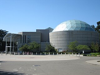
Chabot Space and Science Center, located in Oakland, California, is a center for learning in Earth and space science, which features interactive exhibits, planetariums, a large screen theater, hands-on activities, and three powerful telescopes.

Anthony Chabot was a nineteenth-century businessman and entrepreneur, notable for his contribution to developing hydraulic mining and for building water systems, especially in the Bay Area, so much that he became known as the "Water King".
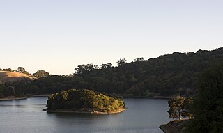
Lake Chabot is a man-made lake covering 317 acres (1.3 km2) in Alameda County, California, United States. Part of the lake lies within Oakland city limits, but most of it lies in unincorporated Castro Valley, just east of San Leandro. It was formed by the damming of San Leandro Creek. The lake was completed in 1875 to serve as a primary source of water for the East Bay.

San Leandro Creek is a 21.7-mile-long (34.9 km) year-round natural stream in the hills above Oakland in Alameda County and Contra Costa County of the East Bay in northern California.

Cull Canyon Regional Recreation Area (CCRRA) is a regional park located in Castro Valley, Alameda County, California. It is part of the East Bay Regional Park District (EBRPD) system.
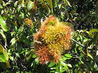
Huckleberry Botanic Regional Preserve is a 241 acres (0.98 km2) regional park and nature reserve in the Oakland Hills, in the eastern East Bay region of the San Francisco Bay Area of California. It is within Alameda and Contra Costa Counties. It is a park within the East Bay Regional Parks District system. The Preserve is named after the California Huckleberry which grows abundantly within its habitat.
Roberts Regional Recreation Area (RRRA) is an area adjacent to Redwood Regional Park located in Alameda County next to Oakland, CA and is part of the East Bay Regional Parks (EBRPD). It is across Skyline Drive from the City of Oakland's Joaquin Miller Park. Kaiser Aluminum and Chemical Corp. adopted Roberts Park in 1979, under the newly-developed Adopt-a-Park program, which promised continued funding. This was the first park in EBRPD to be so adopted.
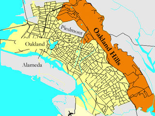
Oakland Hills is an informal term used to indicate the city neighborhoods lying within the eastern portion of Oakland, California. The northernmost neighborhoods were devastated by the Oakland firestorm of 1991.
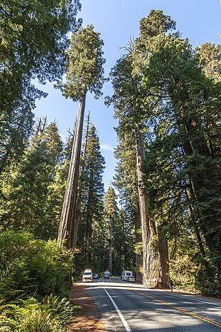
Sequoia sempervirens is the sole living species of the genus Sequoia in the cypress family Cupressaceae. Common names include coast redwood, coastal redwood and California redwood. It is an evergreen, long-lived, monoecious tree living 1,200–2,200 years or more. This species includes the tallest living trees on Earth, reaching up to 115.9 m (380.1 ft) in height and up to 8.9 m (29 ft) in diameter at breast height. These trees are also among the longest-living trees on Earth. Before commercial logging and clearing began by the 1850s, this massive tree occurred naturally in an estimated 810,000 ha along much of coastal California and the southwestern corner of coastal Oregon within the United States. Being the tallest tree species, with a small range and an extremely long lifespan, many redwoods are preserved in various state and national parks; many of the largest specimens have their own official names.

The history of Oakland, a city in the county of Alameda, California, can be traced back to the founding of a settlement by Horace Carpentier, Edson Adams, and Andrew Moon in the 19th century. The area now known as Oakland had seen human occupation for thousands of years, but significant growth in the settlements that are now incorporated into the city did not occur until the Industrial Revolution. Oakland was first incorporated as a town in 1852.

Blossom Rock was a serious navigational hazard to sailing ships entering or leaving San Francisco Bay in the 19th century. It was formally reported by Captain F. Beechey of the Royal Navy ship HMS Blossom in 1827.
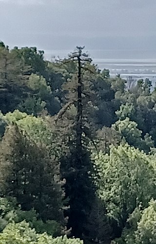
Old Survivor, also known as the Grandfather Tree, is the last remaining old-growth coastal redwood of the East Bay Redwoods that once populated the Oakland Hills in California.

The East Bay Redwoods are an isolated population of coast redwoods that exist a considerable distance inland from the coast in the Berkeley Hills in western Contra Costa County, California. Stands of Sequoia sempervirens, the Coast Redwood, occur on the west coast from Big Sur to extreme southwestern Oregon. Their preferred habitat is the temperate and perennially foggy western slopes of the California Coast Ranges; a reliance on marine climates generally restricts their range to a narrow band along the central and northern coasts of California.

Redwood Creek is an approximately 4 mile-long perennial creek in Contra Costa and Alameda Counties, in the San Francisco Bay Area. It is named for the East Bay Redwoods forest where it originates.


