Erakala, Queensland

Last updated

Erakala
Queensland
Australia Queensland location map.svg
Red pog.svg
Erakala
Coordinates 21°07′56″S149°06′56″E / 21.1322°S 149.1155°E / -21.1322; 149.1155 (Erakala (centre of locality))
Population763 (2021 census) [1]
 • Density61.53/km2 (159.4/sq mi)
Postcode(s) 4740
Area12.4 km2 (4.8 sq mi)
Time zone AEST (UTC+10:00)
Location
LGA(s) Mackay Region
State electorate(s) Whitsunday
Federal division(s) Dawson
Suburbs around Erakala:
Farleigh Farleigh Glenella
Dumbleton Erakala Foulden
Alexandra Te Kowai Racecourse

Erakala is a mixed-use locality in the Mackay Region, Queensland, Australia. [2] In the 2021 census, Erakala had a population of 763 people. [1]

Contents

Geography

Located approximately 10 kilometres (6.2 mi) west of the Mackay CBD, the locality is bounded to the south by the Pioneer River. [3]

The Mackay Ring Road crosses the river from the south (Te Kowai / Racecourse) and is the south-eastern boundary of the locality before continuing north through the locality exiting to Glenella to the north-east. [3]

The Bruce Highway forms two short segments of the locality's northern boundary entering from the north-east (Glenella) and exiting to the north-west (Farleigh). [3]

The North Coast railway line enters the locality from the east (Foulden) heading north-west, forming part of the locality's north-eastern boundary before crossing the Bruce Highway and exiting to the north (Fairleigh / Glenella). [3] The locality was historically served by the former Erakala railway station ( 21°07′38″S149°08′00″E / 21.1271°S 149.1334°E / -21.1271; 149.1334 (Erakala railway station (former)) ). [4]

Most of the land in the south of the locality is low-lying (approx 10 metres (33 ft) above sea level), particularly the land near the river. This land is almost entirely used for growing sugarcane and there is a network of cane tramways to transported the harvested sugarcane to the local sugar mills. [4] [3]

The northern parts of the locality are more elevated, rising to 140 metres (460 ft). This land is increasingly used for rural residential and suburban housing. [3] [5]

History

The locality takes its name from the former Erakala railway station, which in turn was named on 12 January 1927 by J. Strachan, the Mackay railway traffic manager of Queensland Railways Department. It is an Aboriginal word meaning "flat". [2] [6]

Demographics

In the 2016 census, Erakala had a population of 547 people. [7]

In the 2021 census, Erakala had a population of 763 people. [1]

Education

There are no schools in Erakala. The nearest government primary schools are Farleigh State School in neighbouring Farleigh to the north and Glenella State School in neighbouring Glenella to the north-east. The nearest government secondary school is Mackay North State High School in North Mackay to the north-east. [3]

Related Research Articles

Te Kowai is a rural locality in the Mackay Region, Queensland, Australia. In the 2016 census Te Kowai had a population of 218 people.

The Leap is a coastal rural locality in the Mackay Region, Queensland, Australia. In the 2021 census, The Leap had a population of 664 people.

<span class="mw-page-title-main">Alexandra, Queensland</span> Suburb of Mackay, Queensland, Australia

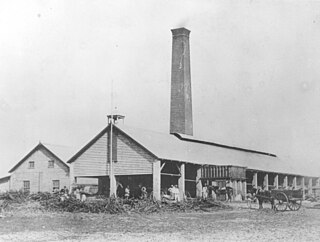
Alexandra is a suburb of Mackay in the Mackay Region, Queensland, Australia. In the 2021 census, Alexandra had a population of 189 people.

<span class="mw-page-title-main">Habana, Queensland</span> Suburb of Mackay Region, Queensland, Australia

Habana is a coastal rural locality in the Mackay Region, Queensland, Australia. In the 2021 census, Habana had a population of 1,022 people.

Glenella is a mixed-use town and suburb of Mackay in the Mackay Region, Queensland, Australia. In the 2016 census, Glenella had a population of 4,519 people.

Hampden is a rural locality in the Mackay Region, Queensland, Australia. In the 2021 census, Hampden had a population of 598 people.

Chelona is a rural locality in the Mackay Region, Queensland, Australia. In the 2021 census, Chelona had a population of 120 people.

McEwens Beach is a coastal town and rural locality in the Mackay Region, Queensland, Australia. In the 2016 census, the locality of McEwens Beach recorded a population of 202 people.

Farleigh is a rural town and locality in the Mackay Region, Queensland, Australia. In the 2016 census the locality of Farleigh had a population of 815 people.

Mount Ossa is a rural town and a coastal locality in the Mackay Region, Queensland, Australia. In the 2016 census, the locality of Mount Ossa had a population of 224 people.

Ooralea is a southern suburb of Mackay in the Mackay Region, Queensland, Australia. In the 2016 census, Ooralea had a population of 3,366 people.

<span class="mw-page-title-main">Mackay Harbour, Queensland</span> Suburb of Mackay, Queensland, Australia

Mackay Harbour is a coastal mixed-use locality in the Mackay Region, Queensland, Australia. In the 2021 census, Mackay Harbour had a population of 686 people.

Placid Hills is a mixed-use locality on the western outskirts of the town of Gatton in the Lockyer Valley Region, Queensland, Australia. In the 2021 census, Placid Hills had a population of 796 people.

<span class="mw-page-title-main">Grasstree Beach, Queensland</span> Suburb of Mackay Region, Queensland, Australia

Grasstree Beach is a coastal locality in the Mackay Region, Queensland, Australia. It contains two towns, Grasstree in the centre of the locality and Zelma on the coast. In the 2021 census, Grasstree Beach had a population of 717 people.

<span class="mw-page-title-main">Foulden, Queensland</span> Suburb of Mackay, Queensland, Australia

Foulden is a rural locality in the Mackay Region, Queensland, Australia. It is on the northern bank of the Pioneer River in Mackay. In the 2021 census, Foulden had a population of 9 people.

Bilyana is a coastal locality in the Cassowary Coast Region, Queensland, Australia. In the 2021 census, Bilyana had a population of 190 people.

Rodgers Creek is a rural locality in the Southern Downs Region, Queensland, Australia. In the 2021 census, Rodgers Creek had a population of 15 people.

Jaffa is a rural locality in the Cassowary Coast Region, Queensland, Australia. In the 2021 census, Jaffa had a population of 35 people.

Maadi is a rural locality in the Cassowary Coast Region, Queensland, Australia. In the 2021 census, Maadi had a population of 49 people.

Jackson South is a rural locality in the Maranoa Region, Queensland, Australia. In the 2021 census, Jackson South had a population of 17 people.

References

  1. 1 2 3 Australian Bureau of Statistics (28 June 2022). "Erakala (SAL)". 2021 Census QuickStats. Retrieved 28 February 2023. OOjs UI icon edit-ltr-progressive.svg
  2. 1 2 "Erakala – locality in Mackay Region (entry 48432)". Queensland Place Names. Queensland Government . Retrieved 29 October 2019.
  3. 1 2 3 4 5 6 7 "Queensland Globe". State of Queensland . Retrieved 6 September 2023.
  4. 1 2 "Railway stations and sidings - Queensland". Queensland Open Data. Queensland Government. 2 October 2020. Archived from the original on 5 October 2020. Retrieved 5 October 2020.
  5. "A sought-after, prized area in Mackay". Townsville Bulletin . 25 August 2019. Archived from the original on 6 September 2023. Retrieved 7 September 2023.
  6. "District Place Names". Daily Mercury . Vol. 56, no. 562. Queensland, Australia. 9 December 1922. p. 8. Retrieved 7 September 2023 via National Library of Australia.
  7. Australian Bureau of Statistics (27 June 2017). "Erakala (SSC)". 2016 Census QuickStats. Retrieved 20 October 2018. OOjs UI icon edit-ltr-progressive.svg