
Hollywood is a neighborhood in the central region of Los Angeles County, California, mostly within the city of Los Angeles. Its name has come to be a shorthand reference for the U.S. film industry and the people associated with it. Many notable film studios, such as Sony Pictures, Walt Disney Studios, Paramount Pictures, Warner Bros. and Universal Pictures, are located near or in Hollywood.

Van Nuys is a neighborhood in the central San Fernando Valley region of Los Angeles, California. Home to Van Nuys Airport and the Valley Municipal Building, it is the most populous neighborhood in the San Fernando Valley.

Commerce is a city located in southeast Los Angeles County, California, United States. The population was 12,823 at the 2010 census, up from 12,568 at the 2000 census. It is usually referred to as the City of Commerce to distinguish it from the common noun. It is bordered by Vernon on the west, Los Angeles on the northwest, East Los Angeles on the north, Montebello on the east, Downey and Bell Gardens on the south, and Maywood on the southwest. The Los Angeles River forms part of its southwestern boundary, and the Rio Hondo separates it from Downey. Commerce is served by the Long Beach and Santa Ana freeways, as well as the Metrolink commuter rail service at the Commerce station.
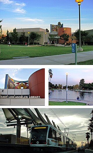
East Los Angeles, or East L.A., is an unincorporated area situated within Los Angeles County, California, United States. According to the United States Census Bureau, East Los Angeles is designated as a census-designated place (CDP) for statistical purposes. The most recent data from the 2020 census reports a population of 118,786, reflecting a 6.1% decrease compared to the 2010 population of 126,496.

Florence-Graham is a census-designated place in Los Angeles County, California. The population was 61,983 at the 2020 census, down from 63,387 at the 2010 census. The census area includes separate communities of Florence, Firestone Park, and Graham. It is located in the south central region of Los Angeles County. The neighboring communities are Central-Alameda, Florence, Green Meadows, Lynwood, Vernon, Walnut Park, Watts, and Compton.

The City of Industry is a city in the San Gabriel Valley, in eastern Los Angeles County, California, United States. The city is almost entirely industrial, containing over 3,000 businesses employing 67,000 people, with only 264 residents as of the 2020 census, making it the third least populous city in the state. It was incorporated on June 18, 1957, and has become the economic hub for the San Gabriel Valley.
Lawndale is a city in Los Angeles County, California, United States. The population was 32,769 at the 2010 census, up from 31,712 according to the 2000 census. The city is in the South Bay region of the Greater Los Angeles Area.

Marina del Rey is an unincorporated seaside community in Los Angeles County, California, with an eponymous harbor that is a major boating and water recreation destination of the greater Los Angeles area. The port is North America's largest man-made small-craft harbor and is home to approximately 5,000 boats. The area is a popular tourism destination for both land and water activities such as paddle board and kayak rentals, dining cruises, and yacht charters. Land activities include bicycling on several bicycle paths, walking paths along the waterfront, and birdwatching (birding). Wildlife watching opportunities include California sea lions and harbor seals. Dolphins and whales occasionally visit the deeper waters of the harbor. This Westside locale is approximately 4 miles (6.4 km) south of Santa Monica, 4 miles (6.4 km) north of Los Angeles International Airport, and 12.5 miles (20.1 km) west-southwest of Downtown Los Angeles.
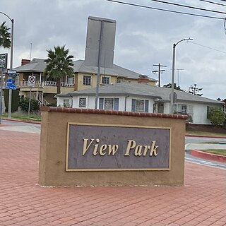
View Park−Windsor Hills is an unincorporated community in Los Angeles County, California. The View Park neighborhood is the community surrounding Angeles Vista Boulevard and the Windsor Hills neighborhood is on the southern end to the north of Slauson Avenue.

Walnut Park is a census-designated place (CDP) in Los Angeles County, California, United States, adjacent to Florence-Graham, Huntington Park and South Gate. The population was 15,966 at the 2010 census, down from 16,180 at the 2000 census.

Westwood is a commercial and residential neighborhood in the northern central portion of the Westside region of Los Angeles, California. It is the home of the University of California, Los Angeles (UCLA). Bordering the campus on the south is Westwood Village, a major regional district for shopping, dining, movie theaters, and other entertainment.

Watts is a neighborhood in southern Los Angeles, California. It is located within the South Los Angeles region, bordering the cities of Lynwood, Huntington Park and South Gate to the east and southeast, respectively, and the unincorporated community of Willowbrook to the south.

Pacoima is a neighborhood in Los Angeles, California. It is one of the oldest neighborhoods in the San Fernando Valley region of LA.

Granada Hills is a neighborhood in the San Fernando Valley region of Los Angeles. The community has a sports program and a range of city recreation centers. The neighborhood has fourteen public and ten private schools.

Mar Vista is a neighborhood on the Westside of Los Angeles, California. In 1927, Mar Vista became the 70th community to be annexed to Los Angeles. It was designated as an official city neighborhood in 2006.
West Los Angeles is an area within the city of Los Angeles, California, United States. The residential and commercial neighborhood is divided by the Interstate 405 freeway, and each side is sometimes treated as a distinct neighborhood, mapped differently by different sources. Each lies within the larger Westside region of Los Angeles County.

Sawtelle is a neighborhood in West Los Angeles, on the Westside of Los Angeles, California. The short-lived City of Sawtelle grew around the Pacific Branch of the National Home for Disabled Volunteer Soldiers, later the Sawtelle Veterans Home, and was incorporated as a city in 1899. Developed by the Pacific Land Company, and named for its manager W. E. Sawtelle, the City of Sawtelle was independent for fewer than 30 years before it was annexed by the City of Los Angeles.

Lake View Terrace is a suburban neighborhood in the San Fernando Valley region of the City of Los Angeles, California.

Lake Balboa is a neighborhood in the San Fernando Valley region of Los Angeles, California. The area was previously part of Van Nuys.
Beverly Glen is a neighborhood in the Santa Monica Mountains region of Los Angeles, California, located around Beverly Glen Boulevard north of Sunset Boulevard and south of Mulholland Drive. Stone Canyon Reservoir lies in the neighborhood.


