Fort Macon State Park is a North Carolina state park in Carteret County, North Carolina, in the United States. Located on Bogue Banks near Atlantic Beach, the park opened in 1936. Fort Macon State Park is the second most visited state park in North Carolina, with an annual visitation of 1.3 million, despite being one of the smallest state parks in North Carolina with 424 acres (1.72 km2). Fort Macon was built as part of the Third System of US fortifications, and was preceded by Fort Hampton of the Second System.

Fort Pickens is a pentagonal historic United States military fort on Santa Rosa Island in the Pensacola, Florida, area. It is named after American Revolutionary War hero Andrew Pickens. The fort was completed in 1834 and was one of the few forts in the South that remained in Union hands throughout the American Civil War. It remained in use until 1947. Fort Pickens is included within the Gulf Islands National Seashore, and as such, is administered by the National Park Service.

Fort McRee was a historic military fort constructed by the United States on the eastern tip of Perdido Key to defend Pensacola and its important natural harbor. In the defense of Pensacola Bay, Fort McRee was accompanied by Fort Pickens, located across Pensacola Pass on Santa Rosa Island, and Fort Barrancas, located across Pensacola Bay on the grounds of what is now Naval Air Station (NAS) Pensacola. Fort Pickens was the largest of these. Very little remains of Fort McRee today.

CSS Oregon was a wooden sidewheel steamer that served as a gunboat in the Confederate States Army during the American Civil War. Built in 1846 for the Mobile Mail Line, she transported mail between New Orleans, Louisiana, and Mobile, Alabama, before the war. In 1861, she was seized by the Governor of Louisiana, Thomas Overton Moore, and served as a blockade runner before being selected for use by the Confederate Army. After transferring men and supplies to Ship Island, she was formally converted into a gunboat and armed with four cannon. Remaining behind on Lake Pontchartrain when many Confederate warships were transferred up the Mississippi River, Oregon served in the Mississippi Sound and Pass Christian areas. She took part in several minor actions involving USS New London, two of which resulted in the Confederates moving into shallow water to avoid close-range action, and the third ending when the Confederate ships abandoned the Pass Christian area. In April 1862, Union pressure confined her and other Confederate ships to Lake Pontchartrain. Later that month, with Union forces closing in on New Orleans, Oregon was sank as a blockship. Her wreck was removed and destroyed in the early 1870s.

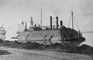
USS Hartford, a sloop-of-war, steamer, was the first ship of the United States Navy named for Hartford, the capital of Connecticut. Hartford served in several prominent campaigns in the American Civil War as the flagship of David G. Farragut, most notably the Battle of Mobile Bay in 1864. She survived until 1956, when she sank awaiting restoration at Norfolk, Virginia.
Fort Pulaski National Monument is located on Cockspur Island between Savannah and Tybee Island, Georgia. It preserves Fort Pulaski; during the American Civil War, the Union Army successfully tested rifled cannon in combat in 1862 there, the success of which rendered brick fortifications obsolete. The fort was also used as a prisoner-of-war camp.

The Fort Zachary Taylor Historic State Park, better known simply as Fort Taylor, is a Florida State Park and National Historic Landmark centered on a Civil War-era fort located near the southern tip of Key West, Florida.
USS Westfield was a sidewheel steam ferryboat in the United States Navy during the American Civil War.

Fort Jay is a coastal bastion fort and the name of a former United States Army post on Governors Island in New York Harbor, within New York City. Fort Jay is the oldest existing defensive structure on the island, and was named for John Jay, a member of the Federalist Party, New York governor, Chief Justice of the United States, Secretary of State, and one of the founding fathers of the United States. It was built in 1794 to defend Upper New York Bay, but has served other purposes. From 1806 to 1904 it was named Fort Columbus, presumably for explorer Christopher Columbus. Today, the National Park Service administers Fort Jay and Castle Williams as the Governors Island National Monument.
Fort Barrancas (1839) or Fort San Carlos de Barrancas is a United States military fort and National Historic Landmark in the former Warrington area of Pensacola, Florida, located physically within Naval Air Station Pensacola, which was developed later around it.

Ship Island is a barrier island off the Gulf Coast of Mississippi, one of the Mississippi–Alabama barrier islands. Hurricane Camille split the island into two separate islands in 1969. In early 2019, the US Army Corps of Engineers completed the first stage of a project rejoining the two islands and recreating one Ship Island. Ship Island is the site of Fort Massachusetts, as a Third System fortification. Part of the island is included in the Gulf Islands National Seashore.

The Battle of Grand Gulf was fought on April 29, 1863, during the American Civil War. As part of Major General Ulysses S. Grant's Vicksburg campaign, seven Union Navy ironclad warships commanded by Admiral David Dixon Porter bombarded Confederate fortifications at Grand Gulf, Mississippi. One of the Confederate fortifications, named Fort Wade, was silenced, but the other, named Fort Cobun, continued firing. Due to the strong Confederate resistance, Grant and Porter decided it was not feasible to make an amphibious landing at Grand Gulf, but later landed at Bruinsburg, Mississippi, instead. After the Confederates were defeated at the Battle of Port Gibson on May 1, Grand Gulf was rendered indefensible and the fortifications were abandoned. The defenders of Grand Gulf then fought at the Battle of Champion Hill on May 16 and the Battle of Big Black River Bridge on May 17, before the start of the Siege of Vicksburg, which ended with a Confederate surrender on July 4. Today, the battlefield is preserved in Grand Gulf Military State Park, which was listed on the National Register of Historic Places in 1972.
The lower seaboard theater of the American Civil War encompassed major military and naval operations that occurred near the coastal areas of the Southeastern United States: in Alabama, Florida, Louisiana, Mississippi, South Carolina, and Texas) as well as southern part of the Mississippi River.

George Leonard Andrews was an American professor, civil engineer, and soldier. He was a brigadier general in the Union Army during the American Civil War and was awarded the honorary grade of brevet major general.
USS Sidney C. Jones was a schooner that served in the Union Navy during the American Civil War. Built in East Haddam, Connecticut, and launched in April 1856, Sidney C. Jones was intended to be used on trade routes. In October 1861, she was purchased by the Union Navy for military service. Originally intended for service on the Union blockade, she was later converted into a mortar schooner and was armed with a mortar and four other cannons. In April 1862, she participated in the bombardment of Confederate positions at Fort Jackson and Fort St. Philip. During July, she ran aground while part of a force bombarding Vicksburg, Mississippi, and was blown up by her crew to prevent capture on July 15.
The 2nd Louisiana Regiment Native Guard Infantry was a regiment in the Union Army during the American Civil War.
The Battle of Lucas Bend took place on January 11, 1862 near Lucas Bend, four miles north of Columbus on Mississippi River in Kentucky as it lay at the time of the American Civil War. In the network of the Mississippi, Tennessee and Ohio rivers, the Union river gunboats under Flag Officer Andrew Hull Foote and General Ulysses S. Grant sought to infiltrate and attack the Confederate positions in Tennessee. On the day of the battle, the Union ironclads Essex and St Louis, transporting troops down the Mississippi in fog, engaged the Confederate cotton clad warships General Polk, Ivy and Jackson and the gun platform New Orleans at a curve known as Lucas Bend in Kentucky. The Essex, under Commander William D. Porter, and the St Louis forced the Confederate ships to fall back after an hour of skirmishing during which the Union commander was wounded. They retreated to the safety of a nearby Confederate battery at Columbus, where the Union vessels could not follow.
William Henry Chase was a Florida militia colonel during the events in early 1861 that led to the American Civil War. On January 15, 1861, on behalf of the State and Governor of Florida, Colonel Chase demanded the surrender of Fort Pickens at Pensacola, Florida and of its U.S. Army garrison. Chase had designed and constructed the fort while he was a captain in the United States Army Corps of Engineers. Lieutenant Adam J. Slemmer, commander of the fort, refused the surrender demand. An informal truce between the administration of President James Buchanan and Florida officials, including their still sitting U.S. Senators, avoided military action at Pensacola until after the Battle of Fort Sumter in April 1861.

Fort Norfolk is a historic fort and national historic district located at Norfolk, Virginia. With the original buildings having been built between 1795 and 1809, the fort encloses 11 buildings: main gate, guardhouse, officers' quarters, powder magazine, and carpenter's shop. Fort Norfolk is the last remaining fortification of President George Washington's 18th century harbor defenses, later termed the first system of US fortifications. It has served as the district office for the U.S. Army Engineer District, Norfolk since 1923.
CSS Carondelet was a sidewheel steamer that served in the Confederate States Navy during the American Civil War. Construction for the vessel started in 1861, and she was launched on January 25, 1862, and commissioned on March 16. Her sister ship was CSS Bienville. On April 4, Carondelet, along with CSS Oregon and CSS Pamlico, took part in a small naval action near Pass Christian against USS New London, USS John P. Jackson, and the troop transport USS Henry Lewis. Carondelet suffered damage to her wheel during the fight, and likely fired the only two shots that struck John P. Jackson. Later that month, with the Confederates abandoning New Orleans, Louisiana, Carondelet was scuttled by her crew in either Lake Pontchartrain, the Tchefuncte River, or the Bogue Falaya River.