Fort Norfolk (Norfolk, Virginia)

Last updated
Fort Norfolk
Plan of Fort Norfolk 1860.jpg
Plan of Fort Norfolk in 1860
Type Star fort
Site information
Owner U.S. Army Corps of Engineers
Open to
the public
Yes
Fort Norfolk
USA Virginia location map.svg
Red pog.svg
Usa edcp location map.svg
Red pog.svg
Location803 Front St., Norfolk, Virginia
Coordinates 36°51′24″N76°18′24″W / 36.85667°N 76.30667°W / 36.85667; -76.30667
Area4 acres (1.6 ha)
Built1794 (1794) [1]
NRHP reference No. 76002225 [2]
VLR No.122-0007
Significant dates
Added to NRHPOctober 29, 1976
Designated VLRDecember 16, 1975 [3]
Conditionintact and occupied
Site history
Built1775 (temporary battery)
1794–1795 (earthwork fort)
1807–1809 (masonry fort)
Built byUnited States Army Corps of Engineers
In use1795–present
MaterialsStone, brick, earth
Battles/wars American Revolution
War of 1812
American Civil War
1781 British map showing forts in the Norfolk-Portsmouth area, including one on the site of the later Fort Norfolk A plan of Portsmouth Harbour in the province of Virginia shewing the works erected by the British forces for its defence, 1781. LOC gm71000689.tif
1781 British map showing forts in the Norfolk-Portsmouth area, including one on the site of the later Fort Norfolk
Fort Norfolk in 1853 Fort Norfolk.jpg
Fort Norfolk in 1853
Battle of Craney Island during the War of 1812 Battle of Craney Island.jpg
Battle of Craney Island during the War of 1812

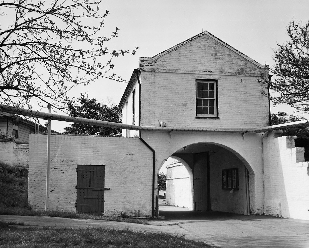
Fort Norfolk is a historic fort and national historic district located at Norfolk, Virginia. With the original buildings having been built between 1795 and 1809, the fort encloses 11 buildings: main gate, guardhouse, officers' quarters, powder magazine, and carpenter's shop. Fort Norfolk is the last remaining fortification of President George Washington's 18th century harbor defenses, later termed the first system of US fortifications. It has served as the district office for the U.S. Army Engineer District, Norfolk since 1923. [5]

Contents

It was listed on the National Register of Historic Places in 1976, [2] and became a Virginia Landmark in 2013. [3] Now it is preserved as a historic fort and is open to the public during the summer. [6]

American Revolution

Although private property at the time, the site of Fort Norfolk was first fortified by citizens of Norfolk during the American Revolutionary War in order provide harbor defense. [5] The fort is located at a point where the Elizabeth River narrows and was used in conjunction with Fort Nelson on the opposite bank of the river in Portsmouth. This was done with the aim of providing a crossfire on any ships attempting to bombard and/or conduct an amphibious assault on Norfolk, Portsmouth, or the Gosport Navy Yard. Ultimately this failed as these positions were too weak to prevent a naval bombardment on Norfolk, later known as the Burning of Norfolk, by Lord Dunmore on January 1, 1776. At the time, Norfolk had been largely abandoned by its mostly pro-British Tory population. Patriot Whig forces made some effort to repel British landing parties, but did nothing to put out the fires and looted abandoned Tory properties. [7]

Construction

In 1794 Congress authorized President George Washington to build defensive fortifications along what they determined the "Maritime Frontier" in order to defend American harbors. This was later termed the first system of US fortifications. [8] By 1795, construction was largely complete on Fort Norfolk. [9] It was originally built with earthen walls and utilized either wooden or brick supports. The northern, eastern, and southern facing sides are designed after a Vauban style star fort. The western side resembles a half moon shape and is called a semicircular bastion. [10] This was an experimental design and the purpose was to maximize the number of cannon overlooking the river. While the design of a semicircular bastion is vulnerable to a land assault, this section of the fort is on the eastern bank of the Elizabeth River; therefore, it was not susceptible to a land assault. In 1797, records showed that Fort Norfolk had only a small caretaker garrison. In 1798 the fort was garrisoned with one company due to the start of the Quasi-War with France. In 1795 Captain Richard S. Blackburn's company was being formed, and by 1799 the company garrisoned both Fort Norfolk and Fort Nelson. [11]

War of 1812

In 1807–1809 the fort was completely rebuilt with masonry, with a capacity of 30 guns and barracks for two companies, as part of the second system of US fortifications. [1] [12] [13] The defensive sea wall was reinforced to reach 12 feet high and 20 feet thick. The eastern and northern inland-facing sides continued to mimic a star fort. A ravelin was added on the east side of the fort to further reinforce the fort in preparation of a land assault. Additionally, this provided needed protection to the Officers' Quarters building, (used as the Shell House during the Civil War) which also served as the center part the eastern perimeter wall. The fort's armament included nine 18-pounder cannons with large quantities of gunpowder, shot, and shell. Although Fort Norfolk itself never saw conflict, it was in operation during the War of 1812. An elongated chain was stretched from Fort Norfolk to Fort Nelson in order to prevent the British Fleet from attacking Gosport Navy Yard, Norfolk, and/or Portsmouth. During the War of 1812, soldiers stationed at Fort Norfolk were sent to reinforce the defense at Craney Island and took part in the Battle of Craney Island. [5] Although the British were repulsed in that battle and did not enter Norfolk, they proceeded up Chesapeake Bay to burn Washington, D.C., and unsuccessfully attack Baltimore, as there were no forts guarding the mouth of the bay at the time.

By the 1830s, the construction of Fort Monroe closed the entrance of Chesapeake Bay to potential enemies and made Fort Norfolk obsolete. Located outside of what were then the city limits, the fort remained standing but it was ungarrisoned. In 1853 local historian William S. Forrest described the fort as "long neglected, and is fast falling into ruins". [5]

Civil War

Prior to the American Civil War, in 1849–1856 a naval powder magazine was added and used to assemble, store, and load munitions for ships built or repaired at what was then the Gosport Navy Yard, now known as Norfolk Naval Shipyard. [14] Later, steps were taken to defend Norfolk from seceding armies. Fort Norfolk was again operational and a garrison company was assigned there.

When Virginia seceded on April 17, 1861, the Union Army was soon forced to abandon both Norfolk and Fort Norfolk. The Confederate Army occupied Norfolk and Portsmouth beginning on April 21, thereby occupying both the fort and the Gosport Shipyard. Fort Norfolk was then used by the Confederate Army to defend the shipyard. The fort's newly added powder magazine also supplied Confederate ships attempting to break the Union blockade on Hampton Roads. The most famous of these encounters was the Battle of Hampton Roads between the ironclads USS Monitor and CSS Virginia (often referred to as the Merrimac(k) because it was previously the USS Merrimack).

The Union Army reoccupied Fort Norfolk in May 1862 after Major General John E. Wool landed at Willoughby and marched on the city of Norfolk. [5] This caused the Confederates to evacuate both the fort and the city, resulting in Norfolk's surrender. For the remainder of the Civil War, under Union occupation, Fort Norfolk was used to imprison captured Confederate blockade runners.

Army Corps of Engineers

The Army Corps of Engineers occupied Fort Norfolk in 1923 and used the fort as offices to plan engineering works for the east coast. [5] During World War II, the fort continued to be used as offices for the Army Corps of Engineers, existing brick structures were renovated, and an additional structure for office use was built. In 1983, a new Army Corps of Engineers building was constructed next to Fort Norfolk, but they still retain offices in the fort. However, in collaboration with the Army Corps of Engineers, the Norfolk Historical Society began making restorations and giving tours of the fort in 1991. [6]

Timeline

(Dates for timeline found at Norfolk Historical Society, 1992 pamphlet on Fort Norfolk (archive link))

See also

Related Research Articles

<span class="mw-page-title-main">Norfolk Naval Shipyard</span> American Navy Shipyard

The Norfolk Naval Shipyard, often called the Norfolk Navy Yard and abbreviated as NNSY, is a U.S. Navy facility in Portsmouth, Virginia, for building, remodeling and repairing the Navy's ships. It is the oldest and largest industrial facility that belongs to the U.S. Navy as well as the most comprehensive. Located on the Elizabeth River, the yard is just a short distance upriver from its mouth at Hampton Roads.

<span class="mw-page-title-main">Fort Schuyler</span>

Fort Schuyler is a preserved 19th century fortification in the New York City borough of the Bronx. It houses a museum, the Stephen B. Luce Library, and the Marine Transportation Department and Administrative offices of the State University of New York Maritime College. It is considered one of the finest examples of early 19th century fortifications. The fort was named in honor of Major General Philip Schuyler of the Continental Army.

<span class="mw-page-title-main">Fort William and Mary</span> United States historic place

Fort William and Mary was a colonial fortification in Britain's worldwide system of defenses, defended by soldiers of the Province of New Hampshire who reported directly to the royal governor. The fort, originally known as "The Castle," was situated on the island of New Castle, New Hampshire, at the mouth of the Piscataqua River estuary. It was renamed Fort William and Mary circa 1692, after the accession of the monarchs William III and Mary II to the British throne. It was captured by Patriot forces, recaptured, and later abandoned by the British in the Revolutionary War. The fort was renamed Fort Constitution in 1808 following rebuilding. The fort was further rebuilt and expanded through 1899 and served actively through World War II.

<span class="mw-page-title-main">Fort Macon State Park</span> State park in North Carolina, United States

Fort Macon State Park is a North Carolina state park in Carteret County, North Carolina, in the United States. Located on Bogue Banks near Atlantic Beach, the park opened in 1936. Fort Macon State Park is the second most visited state park in North Carolina, with an annual visitation of 1.3 million, despite being one of the smallest state parks in North Carolina with 424 acres (1.72 km2). Fort Macon was built as part of the Third System of US fortifications, and was preceded by Fort Hampton of the Second System.

<span class="mw-page-title-main">Elizabeth River (Virginia)</span> River in Virginia

The Elizabeth River is a 6-mile-long (10 km) tidal estuary forming an arm of Hampton Roads harbor at the southern end of Chesapeake Bay in southeast Virginia in the United States. It is located along the southern side of the mouth of the James River, between the cities of Portsmouth, Norfolk, and Chesapeake. Forming the core of the Hampton Roads harbor, it is heavily supported by its tributaries which depend upon it.

<span class="mw-page-title-main">Fort Moultrie</span> United States historic place

Fort Moultrie is a series of fortifications on Sullivan's Island, South Carolina, built to protect the city of Charleston, South Carolina. The first fort, formerly named Fort Sullivan, built of palmetto logs, inspired the flag and nickname of South Carolina, as "The Palmetto State". The fort was renamed for the U.S. patriot commander in the Battle of Sullivan's Island, General William Moultrie. During British occupation, in 1780–1782, the fort was known as Fort Arbuthnot.

<span class="mw-page-title-main">Fort Monroe</span> Moated, six-sided, historical bastion fort in Hampton, Virginia

Fort Monroe is a former military installation in Hampton, Virginia, at Old Point Comfort, the southern tip of the Virginia Peninsula, United States. It is currently managed by partnership between the Fort Monroe Authority for the Commonwealth of Virginia, the National Park Service, and the city of Hampton as the Fort Monroe National Monument. Along with Fort Wool, Fort Monroe originally guarded the navigation channel between the Chesapeake Bay and Hampton Roads—the natural roadstead at the confluence of the Elizabeth, the Nansemond and the James rivers.

<span class="mw-page-title-main">Battle of Craney Island</span>

The Battle of Craney Island was a victory for the United States during the War of 1812. The battle saved the city of Norfolk, and the adjacent city of Portsmouth, from British invasion. Especially important to Virginia and northeastern North Carolina, the region was a major hub for American commerce.

<span class="mw-page-title-main">Craney Island (Virginia)</span> Island in Virginia, United States

Craney Island is a point of land in the independent city of Portsmouth in the South Hampton Roads region of eastern Virginia in the United States. The location, formerly in Norfolk County, is near the mouth of the Elizabeth River opposite Lambert's Point on Hampton Roads. It is home to the Craney Island US Naval Supply Center, managed by the U.S. Army Corps of Engineers.

<span class="mw-page-title-main">Fort Adams</span>

Fort Adams is a former United States Army post in Newport, Rhode Island that was established on July 4, 1799 as a First System coastal fortification, named for President John Adams who was in office at the time. Its first commander was Captain John Henry who was later instrumental in starting the War of 1812. The current Fort Adams was built 1824–57 under the Third System of coastal forts; it is part of Fort Adams State Park today.

<span class="mw-page-title-main">Seacoast defense in the United States</span> Coastal forts construction and maintenance in the U.S.

Seacoast defense was a major concern for the United States from its independence until World War II. Before airplanes, many of America's enemies could only reach it from the sea, making coastal forts an economical alternative to standing armies or a large navy. After the 1940s, it was recognized that fixed fortifications were obsolete and ineffective against aircraft and missiles. However, in prior eras foreign fleets were a realistic threat, and substantial fortifications were built at key locations, especially protecting major harbors.

<span class="mw-page-title-main">Siege artillery in the American Civil War</span>

Siege artillery is heavy artillery primarily used in military attacks on fortified positions. At the time of the American Civil War, the U.S. Army classified its artillery into three types, depending on the gun's weight and intended use. Field artillery were light pieces that often traveled with the armies. Siege and garrison artillery were heavy pieces that could be used either in attacking or defending fortified places. Seacoast artillery were the heaviest pieces and were intended to be used in permanent fortifications along the seaboard. They were primarily designed to fire on attacking warships. The distinctions are somewhat arbitrary, as field, siege and garrison, and seacoast artillery were all used in various attacks and defenses of fortifications. This article will focus on the use of heavy artillery in the attack of fortified places during the American Civil War.

<span class="mw-page-title-main">Naval Medical Center Portsmouth</span> U.S. Navy medical facility in Virginia

The Naval Medical Center Portsmouth (NMCP), formerly Naval Hospital Portsmouth, and originally Norfolk Naval Hospital, is a United States Navy medical center in Portsmouth, Virginia, United States. It is the oldest continuously running hospital in the Navy medical system.

<span class="mw-page-title-main">Drydock Number One, Norfolk Naval Shipyard</span> United States historic place

Drydock Number One is the oldest operational drydock facility in the United States. Located in Norfolk Naval Shipyard in Portsmouth, Virginia, it was put into service in 1834, and has been in service since then. Its history includes the refitting of USS Merrimack, which was modified to be the Confederate Navy ironclad CSS Virginia. It was declared a National Historic Landmark in 1971.

<span class="mw-page-title-main">Fort Pickering</span> United States historic place

Fort Pickering is a 17th-century historic fort site on Winter Island in Salem, Massachusetts. Fort Pickering operated as a strategic coastal defense and military barracks for Salem Harbor during a variety of periods, serving as a fortification from the Anglo-Dutch Wars through World War II. Construction of the original fort began in 1643 and it saw use as a military installation into the 20th century. Fort Miller in Marblehead also defended Salem's harbor from the 1630s through the American Civil War. Fort Pickering is a First System fortification named for Colonel Timothy Pickering, born in Salem, adjutant general of the Continental Army and secretary of war in 1795. Today, the remains of the fort are open to the public as part of the Winter Island Maritime Park, operated by the City of Salem.

<span class="mw-page-title-main">Fort Sewall</span> United States historic place

Fort Sewall is a historic coastal fortification in Marblehead, Massachusetts. It is located at Gale's Head, the northeastern point of the main Marblehead peninsula, on a promontory that overlooks the entrance to Marblehead Harbor. Until 1814 it was called Gale's Head Fort.

<span class="mw-page-title-main">Fort Defiance (Massachusetts)</span>

Fort Defiance was a fort that existed from 1794 to after 1865 on Fort Point in Gloucester, Massachusetts. The location protecting the inner harbor was also called Watch House Point.

<span class="mw-page-title-main">Fort Stark</span>

Fort Stark is a former military fortification in New Castle, New Hampshire, United States. Located at Jerry's Point on the southeastern tip of New Castle Island, most of the surviving fort was developed in the early 20th century, following the Spanish–American War, although there were several earlier fortifications on the site, portions of which survive. The fort was named for John Stark, a New Hampshire officer who distinguished himself at the Battle of Bennington in the American Revolution. The purpose of Fort Stark was to defend the harbor of nearby Portsmouth and the Portsmouth Naval Shipyard. The fort remained in active use through the Second World War, after which it was used for reserve training by the US Navy. The property was partially turned over to the state of New Hampshire in 1979, which established Fort Stark Historic Site, and the remainder of the property was turned over in 1983. The grounds are open to the public during daylight hours.

<span class="mw-page-title-main">Fort Nelson (Virginia)</span>

Fort Nelson was a fort located on Hospital Point in Portsmouth, Virginia, which is currently the site of the Portsmouth Naval Hospital. The fort was named for Thomas Nelson Jr., governor of Virginia in 1781. It and Fort Norfolk were built to guard the Elizabeth River, including the cities of Norfolk and Portsmouth and the Gosport Navy Yard. The fort was originally built by patriot forces with funding from the Virginia government in 1776 during the American Revolutionary War, but destroyed when the British occupied the area in 1779. A British map shows that they rebuilt the fort by 1781. Following the Revolution, the fort was again rebuilt in 1794 under the first system of US fortifications, was garrisoned in the War of 1812, but was demolished in 1827 to make room for the naval hospital. The fort was again rebuilt by Confederate forces in 1861, but the Confederates evacuated the area in May 1862 and the fort was eventually demolished.

The Harbor Defenses of Portsmouth was a United States Army Coast Artillery Corps harbor defense command. It coordinated the coast defenses of Portsmouth, New Hampshire and the nearby Portsmouth Naval Shipyard in Kittery, Maine from 1900 to 1950, both on the Piscataqua River, beginning with the Endicott program. These included both coast artillery forts and underwater minefields. The command originated circa 1900 as the Portsmouth Artillery District, was renamed Coast Defenses of Portsmouth in 1913, and again renamed Harbor Defenses of Portsmouth in 1925.

References

  1. 1 2 Fort Norfolk at American Forts Network
  2. 1 2 "National Register Information System". National Register of Historic Places . National Park Service. July 9, 2010.
  3. 1 2 "Virginia Landmarks Register". Virginia Department of Historic Resources. Retrieved 19 March 2013.
  4. 1 2 Lossing, Benson (1868). The Pictorial Field-Book of the War of 1812. Harper & Brothers, Publishers. p. 668.
  5. 1 2 3 4 5 6 Virginia Historic Landmarks Commission Staff (December 1975). "National Register of Historic Places Inventory/Nomination: Fort Norfolk" (PDF). Virginia Department of Historic Resources. and Accompanying photo
  6. 1 2 Fort Norfolk at U.S. Army Engineer District, Norfolk website
  7. Russell, David Lee (2000). The American Revolution in the Southern colonies. Jefferson, NC: McFarland. p. 74. ISBN   978-0-7864-0783-5. OCLC   248087936.
  8. Wade 2011, pp. 10–15, 59.
  9. Wade 2011, p. 28.
  10. Lewis, Emanuel Raymond (1979). Seacoast Fortifications of the United States. Annapolis: Leeward Publications. pp. 26, 28. ISBN   978-0-929521-11-4.
  11. Wade, Arthur P. (2011). Artillerists and Engineers: The Beginnings of American Seacoast Fortifications, 1794–1815. CDSG Press. pp. 28, 42, 45, 58. ISBN   978-0-9748167-2-2.
  12. Fort Norfolk at FortWiki.com
  13. Wade 2011, pp. 238, 245.
  14. Roberts, Robert B. (1988). Encyclopedia of Historic Forts: The Military, Pioneer, and Trading Posts of the United States. New York: Macmillan. p. 819. ISBN   0-02-926880-X.