GTA West Corridor

Last updated

Highway 413
GTA West Corridor
     GTA West Corridor     Highway 410 and 427 extensions (proposed)
Route information
Maintained by Ministry of Transportation of Ontario
Length52 km [1]  (32 mi)
History
  • Proposed September 2003
  • Cancelled February 9, 2018 [2]
  • Revived November 2018 [3]
Major junctions
West endOntario 401 crown.svg Highway407crest.svg  Highway 401  / 407 ETR in Halton Hills
Major intersectionsOntario 410 crown.svg  Highway 410 south in Caledon
Ontario 427 crown.svg  Highway 427 south near Bolton
East endOntario 400 crown.svg  Highway 400 in Vaughan
Highway system

The GTA West Corridor (GTA West) is a proposed 400-series highway and bus transitway in the western Greater Toronto Area of the Canadian province of Ontario. The approximately 52-kilometre (32 mi) route is currently undergoing planning and analysis under an environmental impact assessment (EA) by both the Ministry of Transportation of Ontario (MTO) and the Government of Ontario, as well as the Impact Assessment Agency of Canada. If approved, a new four-to-six lane controlled-access highway would be built between the existing interchange of Highway 401 and the 407 ETR at the HaltonPeel boundary, and Highway 400 north of Vaughan. In addition, two new extensions would be built to connect Highway 410 and Highway 427 with the GTA West. Some stakeholders have referred to the GTA West as Highway 413, [4] [5] following the nomenclature of other 400-series highways in Ontario. However, the GTA West has not received a route number from the MTO at that time. [6] The Ontario government made the Highway 413 designation official on November 10, 2021. [7]

Contents

The proposed highway would serve as an outer ring road around the built-up areas of Brampton and Vaughan that would permit traffic travelling between Southwestern Ontario and Ontario's cottage country or Northern Ontario to bypass much of the Greater Toronto Area. However, the highway has attracted criticism for its environmental impacts, including concerns about its footprint on designated farmland in the Greenbelt, as well as its implications in encouraging urban sprawl and induced demand.

Planning for the corridor began in the mid 2000s. However the EA was suspended in 2015, and the project shelved in February 2018 by the Liberal government of Kathleen Wynne. Following the 2018 Ontario general election in June of that year, the new Progressive Conservative government of Doug Ford announced the resumption of suspended EA in November. Since then, several of the municipalities along the route have voiced their opposition to its construction.

Route description

The proposed route of the GTA West Corridor was confirmed in the Technically Preferred Route report, which was published by Aecon and released on August 7, 2020. [8] The approximately 52 km (32 mi) route would consist of a four-to-six lane freeway as well as a transitway situated within a 170-metre (560 ft)-wide right-of-way. [9] [1] Fifteen interchanges were proposed. Four of the interchanges, including both termini, would be freeway-to-freeway. The corridor would arch around the west and north sides of the rural–urban fringe of Brampton, skirting the boundary between the regions of Halton and Peel before proceeding northwest into York Region. [8] [10]

The southwestern end would be at a freeway-to-freeway connection at the existing interchange between Highway 401 and Highway 407ETR at the tripoint of Halton Hills, Milton and Mississauga. [11] It would meander northward, entering Brampton at an interchange with Winston Churchill Boulevard. Crossing the Credit River immediately east of Georgetown, it would gradually curve northwest to parallel Old School Road east of Heritage Road. It would interchange with Regional Road 107 (Bovaird Drive), which is known as Highway 7 to the west beyond the Brampton–Halton Hills boundary. Midway between Bovaird Drive and the next interchange at Peel Regional Road 14 (Mayfield Road), the freeway would cross the CN Halton Subdivision, which carries the Kitchener line of GO Transit. [8] [10]

The Highway 410 extension, opened in 2009, would be bypassed by the construction of the GTA West. 410 Extension.png
The Highway 410 extension, opened in 2009, would be bypassed by the construction of the GTA West.

Beyond Mayfield Road, the GTA West Corridor would make a broad curve to the northeast into Caledon, passing Peel Regional Road 1 (Mississauga Road). Travelling roughly parallel to and midway between Mayfield Road and Peel Regional Road 9 (King Street), it would pass northwest of Snelgrove after interchanges with Chinguacousy Road and Highway 10. [8] [10] To the east of Snelgrove, a new extension of Highway 410, bypassing 4 km (2.5 mi) of the extension south of Snelgrove that opened November 16, 2009, would meet the GTA West at a freeway-to-freeway interchange. [12] [13] To the east would be an incomplete interchange with Bramalea Road. After interchanges with Peel Regional Road 7 (Airport Road) and Peel Regional Road 8 (The Gore Road), the route would curve east to pass between the town of Bolton and the Brampton neighbourhood of Castlemore. An interchange at Humber Station Road would provide access to Mayfield Road, which the GTA West corridor would cross. [8] [10]

The GTA West would cross the Peel–York regional boundary at Regional Road 50 (former Highway 50) immediately north of York Regional Road 49 (Nashville Road; former Highway 49), where it would encounter a freeway-to-freeway interchange with an extension of Highway 427 at Major Mackenzie Drive West (York Regional Road 25). [8] Curving northeast, the proposed route would encounter the CP MacTier Subdivision before crossing over the Humber River at the location of the Humber Valley Heritage Trail. [14] Between the main branch and east branch of the Humber River would be an interchange with York Regional Road 27 (former Highway 27) north of Kleinburg. The final several kilometres would travel east, midway between Kirby Road and King Vaughan Road. After an incomplete interchange with Weston Road (York Regional Road 56) it would end at a freeway-to-freeway interchange with Highway 400. [8] [10]

History

2002 to 2018

The GTA West Corridor was first conceived as the GTA East–West Economic Corridor by the Ministry of Transportation of Ontario (MTO) in its Central Ontario Strategic Transportation Directions study in January 2002. [15] The North–South Corridor Feasibility Study, prepared for the MTO and City of Brampton in September 2003, was first to recommend acquiring land for a future "higher order transportation facility" around Brampton. [16] The report identified the need for a controlled-access highway as part of the city's ultimate transportation plan to serve western Brampton. Land was subsequently set aside for the next several years while the MTO analysed the need for both corridors. [17]

In 2005, the Government of Ontario passed the Places to Grow Act, which set forth consistent urban planning principles across the province for the following 25 years. The Growth Plan for the Greater Golden Horseshoe was released in June of the following year as a framework for implementing the act, [18] with a future transportation corridor identified north of Highway 401 between Guelph and Vaughan. [19] Following the submission of a Terms of Reference on June 15, 2007, an EA began [note 1] on March 4, 2008, to establish conceptual routes for additional transportation infrastructure to interconnect the GTA West economic centres (Milton, Brampton and Vaughan) with Guelph and Waterloo Region. [21] [22] The early concepts for the GTA West Corridor considered five different options, including two extending as far west as Guelph without intersecting Highway 401 or Highway 407. [23] When combined with the planned Highway 7N west of Guelph, they would have resulted in a parallel freeway to the north of Highway 401 between Kitchener/Waterloo and Vaughan. [note 2]

Simultaneously, the City of Brampton appealed an amendment of the Halton Region Official Plan to the Ontario Municipal Board. As a result, the North–South Corridor Feasibility Study evolved into the Halton–Peel Boundary Area Transportation Study (HPBATS), which commenced on April 11, 2007. [26] [27] HPBATS recommended a north–south route, known as the Halton–Peel Freeway, east of Georgetown and west of Brampton as a complementary project that would connect in the north with the potential GTA West Corridor. The completed study and its recommendations were submitted to the MTO in late April 2010. [28] In 2012 the provincial EA recommended that the GTA West should follow a broadly similar corridor to the Halton–Peel Freeway. [29]

Stage 1 of the GTA West EA concluded with the recommendation that the Highway 401 and Highway 407 ETR interchange (pictured, facing north) serve as the western terminus of the proposed freeway. Highway 407ETR at Highway 401.jpg
Stage 1 of the GTA West EA concluded with the recommendation that the Highway 401 and Highway 407 ETR interchange (pictured, facing north) serve as the western terminus of the proposed freeway.

Stage 1 of the EA concluded with the release of the GTA West Transportation Development Strategy Report in November 2012. The report indicated limited demand for and the considerable environmental consequences of a new crossing of the Niagara Escarpment. It recommended not proceeding further with a new route over the escarpment, instead favouring a connection to Highway 401 west of Mississauga, including the route of the proposed Halton–Peel Freeway. An alternative route, connecting with Highway 401 west of Milton and travelling between 5 Side Road and 10 Side Road through Halton Hills, was also not carried forward, with the MTO instead electing to widen Highway 401 to 12 lanes between Milton and Mississauga. [30] [31]

Stage 2 of the GTA West EA began in February 2014, intended to further refine the study corridor to a preliminary design. [32] However, by this point public opposition to the corridor began to appear, with the group Environmental Defence starting a campaign against the proposed highway by 2015. [33] On December 16, 2015, Minister of Transportation Steven Del Duca announced the suspension of the EA process. [34] A three-member advisory panel [note 3] was formed in October 2016 to assess alternative approaches to meet projected traffic levels. [36] The suspension was opposed by the municipalities of Vaughan, King, York Region, Caledon and Peel Region, [37] as well as Brampton. [38] The advisory panel report was released on May 29, 2017, [39] recommending that the EA be stopped, and the "development of a single transportation plan for the Greater Golden Horseshoe" proceed in its place. [40] The panel also recommended that the provincial government negotiate with the private operators of the 407 ETR to encourage the routing of more truck traffic onto that route, alleviating congestion on the 401, and negating the need for the GTA West. [41] Consequently the Ontario government cancelled the GTA West Study on February 9, 2018. [4] [5] [42] In the run up to the 2018 provincial election, the Progressive Conservatives stated that they would complete the EA of the project if elected. [43]

2018 to present

The 2018 Ontario general election, held on June 7, 2018, ended the 15-year tenure of the Ontario Liberal Party and saw Premier Kathleen Wynne defeated by the Progressive Conservatives (PCs) under Doug Ford. [44] As part of the PCs Fall Economic Statement, released in November 2018, the government committed to the campaign pledge of resuming the suspended EA for the GTA West Corridor, "in order to speed up travel and alleviate traffic congestion". [3] The EA was subsequently resumed on June 5, 2019. [45] [46] In September and October of that year, a series of Public Information Centres were held in which the preferred route and interchange locations were announced. [47] This route, with modifications, [note 4] was confirmed publicly by the provincial government on August 7, 2020. [49] The EA for the corridor is expected to be complete by the end of 2022. [50]

On February 3, 2021, Jonathan Wilkinson, the federal Minister of Environment and Climate Change announced that he had received a request for the project to undergo an EA at the federal level, [51] following a formal request from Environmental Defence. [52] [53] [54] On May 3, 2021, Wilkinson announced that a federal EA would take place. [55] [56] [57] In response, provincial Minister of Transportation Caroline Mulroney stated that she would work with the federal government to address “newly found concerns" on potential adverse effects on species at risk. [57]

Funding was committed to the project as part of the fall economic statement on November 1, 2021. [58]

Impacts and environmental concerns

The highway has attracted criticism from municipalities, politicians, campaign groups and the public regarding its potential impacts. [59] [60] [61]

Environmental groups have criticised the significant impact that the highway would have on the environment. In addition to increasing air pollution and greenhouse gas emissions, opponents claim the highway would disrupt woodlands, waterways, wetlands, wildlife habitats and species at risk. [62] [63] The highway will travel through both the Greenbelt, the Whitebelt (an area of land left unprotected from development when the Greenbelt was established in 2005) and the Humber and Credit watersheds. [64] According to the Toronto and Region Conservation Authority, the highway would specifically impact 85 waterways, 220 wetlands, 10 different species at risk and hundreds of acres of vulnerable wildlife habitat. [62]

Urban planning critics claim the highway will encourage urban sprawl through induced demand, [65] [66] as research shows that building new highways tends to attract more drivers and fails to improve congestion levels on other roads. [67] Consequently, they claim it would increase car dependency in surrounding areas and ultimately only save commuters around 30 to 60 seconds of travel time. [4] Other groups, such as the National Farmers Union have concerns about the impacts of the highway on agricultural land, as the highway would be built on around 2,000 acres of Class 1 and 2 farmland – the most productive designation. [68] A planning land use expert noted that "agricultural land is valued as low as C$18,000 an acre, but residential land is easily worth C$1 million an acre" and that billions of dollars could be made if farmland adjacent to the highway was rezoned as land for development. [64] Avison Young, a real estate services firm, estimated around 62,000 acres (250 km2) of developable land is available located within 2 kilometres (1.2 mi) of the 16 proposed interchanges. [69] In 2021, a Toronto Star investigation noted that 3,300 acres (13 km2) of land along the route was owned by 8 major property developers, several of which had donated to Doug Ford’s Progressive Conservative government. [70]

Other critics have noted the high cost of building the highway – the cost of construction in 2012 was estimated at C$4.7 billion, with recent estimates around C$6 billion. [59] It is unclear whether the highway would be tolled, similar to Highway 407, Highway 412 and Highway 418. [6] As an alternative to a new freeway, stakeholders have suggested investing in local transportation improvements. Some proposed suggestions include improvements to local roads, truck priority lanes on Highway 407, public transit investments including GO Transit Regional Express Rail and widening of existing highways. [60] [71] Others have suggested working with the owners of Highway 407 to increase capacity on that highway instead. [41] A study commissioned by the previous provincial government stated that the highway would save drivers between 30 and 60 seconds of travel time, while the MTO stating in 2021 that the highway would save drivers 30 minutes. [72]

Perspectives

Lawn sign in Caledon (labelling the proposed route as "Highway 413") opposing the highway's construction Stop the 413 sign.jpg
Lawn sign in Caledon (labelling the proposed route as "Highway 413") opposing the highway's construction

The majority of local municipalities have opposed the project, including Mississauga, [1] Vaughan, [73] Halton Hills, [61] Halton Region, [61] Peel Region, [74] King Township [75] and Orangeville. [76] Brampton and Caledon withdrew their support of the fast-tracked environmental assessment. [61] [77] The NDP opposition in the Legislative Assembly of Ontario, the Green Party of Ontario [78] and Ontario Liberal Party have stated that they would scrap the highway following the next provincial election. [79] [80] Despite the corridor not directly impacting the City of Toronto itself, Toronto City Council passed a resolution in March 2021 condemning the proposed highway. [81]

Supporters of the freeway include Regional Municipality of York [82] as well as the Progressive Conservative government. [43] Several non-governmental organizations such as the Ontario Trucking Association, [83] the Building Industry and Land Development Association (BILD), [84] and the Association of Municipalities of Ontario also continue to support the project. [85] The Ryerson University Centre for Urban Research and Land Development (CUR) also specifically supported the streamlining of the EA process, noting that “It is simply taking too long to bring critical infrastructure improvements such as roads, transit, sewers and water to completion". [86]

Exit list

The following are the proposed exits as shown in the Preferred Route. [47] [49] The following table lists the major junctions along GTA West Corridor. 

DivisionLocationkmmiDestinationsNotes
Halton MiltonHalton Hills boundary00.0Ontario 401 crown.svg Highway407crest.svg  Highway 401  / 407 ETR
HaltonPeel boundaryHalton Hills – Brampton boundary42.5Peel RR 19 jct.svg  Regional Road 19 (Winston Churchill Boulevard)
Peel Brampton 74.3
Bridge over the Credit River
95.6Peel RR 107 jct.svg  Regional Road 107 (Bovaird Drive)Former Highway 7 [note 5]
Brampton – Caledon boundary138.1Peel RR 14 jct.svg  Regional Road 14 (Mayfield Road)
Caledon1912Chinguacousy Road
2214Ontario 10 crown.svg  Highway 10 (Hurontario Street) – Orangeville
2616Ontario 410 crown.svg  Highway 410 southDiversion of Highway 410 on east side of Snelgrove
2717Bramalea Road Partial-access interchange with westbound exit and eastbound entrance
3019Peel RR 7 jct.svg  Regional Road 7 (Airport Road) – Caledon East
3522Peel RR 8 jct.svg Regional Road 8 (The Gore Road)
3723Humber Station Road – Bolton
York Vaughan 4025Ontario 427 crown.svg  Highway 427 south
4427RR 27 jct.svg  Regional Road 27 (Highway 27) – Kleinburg, Nobleton Former Highway 27 [note 6]
5132RR 56 jct.svg  Regional Road 56 (Weston Road)Partial-access interchange with eastbound exit and westbound entrance
5232Ontario 400 crown.svg  Highway 400
1.000 mi = 1.609 km; 1.000 km = 0.621 mi
  •       Proposed

Notes

  1. "Subsection 13(1) of the Environmental Assessment Act allows a person to apply to the Minister of the Environment to approve a class environmental assessment with respect to a class of undertakings. The application consists of a proposed terms of reference and subsequently a class environmental assessment." [20]
  2. Both options 4-4 and 4-5 would have connected the Hanlon Expressway with Highway 400. [24] Highway 7N will connect Kitchener/Waterloo with the north end of the Hanlon Expressway. [25]
  3. The three-member GTA West Advisory Panel consisted of former Deputy Minister of the Environment Gail Beggs, environmental lawyer Rodney Northey, and Ryerson urban planning professor Dr. Matthias Sweet. [35]
  4. As a result of an approved subdivision proposal north of the GTA West Corridor, the Coleraine Drive interchange was moved to Humber Station Road. [48] [49]
  5. The Bovaird Drive portion of Highway 7 was transferred to the Regional Municipality of Peel on November 28, 2001. [87]
  6. York Regional Road 27 carries the name "Highway 27", [88] despite not being a provincial highway since January 1, 1998. [89]

Related Research Articles

Brampton City in Ontario, Canada

Brampton is a city in the Canadian province of Ontario. Brampton is a city in the Greater Toronto Area (GTA) and is a lower-tier municipality within Peel Region. The city has a population of 593,638 as of the Canada 2016 Census, making it the ninth most populous municipality in Canada and the third most populous city in the Greater Golden Horseshoe urban area, behind Toronto and Mississauga.

Greater Toronto Area Metropolitan area in Ontario, Canada

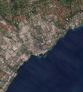
The Greater Toronto Area (GTA) is the most populous metropolitan area in Canada. It includes the City of Toronto and the regional municipalities of Durham, Halton, Peel, and York. In total, the region contains 25 urban, suburban, and rural municipalities. The Greater Toronto Area begins in Burlington in the Halton Region, and extends along Lake Ontario past downtown Toronto eastward to Clarington in the Durham Region.

Ontario Highway 401 Controlled-access highway in Ontario

King's Highway 401, commonly referred to as Highway 401 and also known by its official name as the Macdonald–Cartier Freeway or colloquially referred to as the four-oh-one, is a controlled-access 400-series highway in the Canadian province of Ontario. It stretches 828 kilometres (514 mi) from Windsor in the west to the Ontario–Quebec border in the east. The part of Highway 401 that passes through Toronto is North America's busiest highway, and one of the widest. Together with Quebec Autoroute 20, it forms the road transportation backbone of the Quebec City–Windsor Corridor, along which over half of Canada's population resides. It is also a Core Route in the National Highway System of Canada. The route is maintained by the Ministry of Transportation of Ontario (MTO) and patrolled by the Ontario Provincial Police. The speed limit is 100 km/h (62 mph) throughout its length, with the only exceptions the posted 80 km/h (50 mph) limit westbound in Windsor and in most construction zones.

Ontario Highway 407 Tolled highway in Ontario

King's Highway 407 is a tolled 400-series highway in the Canadian province of Ontario. Comprising a privately leased segment as well as a publicly owned segment, the route spans the entire Greater Toronto Area (GTA) around the city of Toronto, travelling through the suburbs of Burlington, Oakville, Mississauga, Brampton, Vaughan, Markham, Pickering, Whitby, and Oshawa before ending in Clarington, north of Orono. At 151.4 km long, this is the fourth longest freeway in Ontario's 400 series network, after Highways 417, 400, and 401. The segment between Burlington and Brougham in Pickering is leased to and operated by the 407 ETR Concession Company Limited and is officially known as the 407 Express Toll Route (407 ETR). It begins at the junction of the Queen Elizabeth Way (QEW) and Highway 403 in Burlington, and travels 108.0 km (67.1 mi) across the GTA to Brock Road in Pickering. East of Brock Road, the tollway continues east as Highway 407, a toll route operated by the provincial government, for 43.4 km (27.0 mi) to Highway 35/115 in Clarington. The route interchanges with nine freeways: the QEW, Highway 403, Highway 401, Highway 410, Highway 427, Highway 400, Highway 404, Highway 412, and Highway 418. Highway 407 is an electronically operated toll highway; there are no toll booths along the length of the route. Distances are calculated automatically using transponders or automatic number-plate recognition, which are scanned at entrance and exit points.

Queen Elizabeth Way Controlled-access highway in Ontario

The Queen Elizabeth Way (QEW) is a 400-series highway in the Canadian province of Ontario linking Toronto with the Niagara Peninsula and Buffalo, New York. The freeway begins at the Peace Bridge in Fort Erie and travels 139.1 kilometres (86.4 mi) around the western end of Lake Ontario, ending at Highway 427 in Toronto. The physical highway, however, continues as the Gardiner Expressway into downtown Toronto. The QEW is one of Ontario's busiest highways, with an average of close to 200,000 vehicles per day on some sections. Major highway junctions are at Highway 420 in Niagara Falls, Highway 405 in Niagara-on-the-Lake, Highway 406 in St. Catharines, the Red Hill Valley Parkway in Hamilton, Highway 403 and Highway 407 in Burlington, Highway 403 at the Oakville–Mississauga boundary, and Highway 427 in Etobicoke. Within the Regional Municipality of Halton, between its two junctions with Highway 403, the QEW is signed concurrently with Highway 403.

400-series highways Ontario freeway network

The 400-series highways are a network of controlled-access highways throughout the southern portion of the Canadian province of Ontario, forming a special subset of the provincial highway system. They are analogous to the Interstate Highway System in the United States or the Autoroute system of neighbouring Quebec, and are regulated by the Ministry of Transportation of Ontario (MTO). The 400-series designations were introduced in 1952, although Ontario had been constructing divided highways for two decades prior. Initially, only Highways 400, 401 and 402 were numbered; other designations followed in the subsequent decades.

Ontario Highway 427 Controlled-access highway in Ontario

King's Highway 427, also known as Highway 427 and colloquially as the 427, is a 400-series highway in the Canadian province of Ontario that runs from the Queen Elizabeth Way (QEW) and Gardiner Expressway in Toronto to Major Mackenzie Drive in Vaughan. It is Ontario's second busiest freeway by volume and the third busiest in North America, behind Highway 401 and Interstate 405 in California. Like Highway 401, a portion of the route is divided into a collector-express system with twelve to fourteen continuous lanes. Notable about Highway 427 are its several multi-level interchanges; the junctions with the QEW/Gardiner Expressway and Highway 401 are two of the largest interchanges in Ontario and were constructed between 1967 and 1971, while the interchanges with Highway 409 and Highway 407 were completed in 1992 and 1995, respectively.

Ontario Highway 409 Controlled-access highway in Ontario

King's Highway 409, commonly referred to as Highway 409 and historically as the Belfield Expressway, is a 400-series highway in the Canadian province of Ontario that extends from Highway 401 in Toronto to Pearson International Airport, west of Highway 427, in Mississauga. It is a short freeway used mainly as a spur route for traffic travelling to the airport or Highway 427 northbound from Highway 401 westbound, as these route movements are not accommodated at the complex interchange between Highways 401 and 427.

Ontario Highway 7 Ontario provincial highway

King's Highway 7, commonly referred to as Highway 7 and historically as the Northern Highway, is a provincially maintained highway in the Canadian province of Ontario. At its peak, Highway 7 measured 716 km (445 mi) in length, stretching from Highway 40 east of Sarnia in Southwestern Ontario to Highway 17 west of Ottawa in Eastern Ontario. However, due in part to the construction of Highways 402 and 407, the province transferred the sections of Highway 7 west of London and through the Greater Toronto Area to county and regional jurisdiction. The highway is now 535.7 km (332.9 mi) long; the western segment begins at Highway 4 north of London and extends 154.1 km (95.8 mi) to Georgetown, while the eastern segment begins at Donald Cousens Parkway in Markham and extends 381.6 km (237.1 mi) to Highway 417 in Ottawa.

Ontario Highway 400 Controlled-access highway in Ontario

King's Highway 400, commonly referred to as Highway 400, historically as the Toronto–Barrie Highway, and colloquially as the 400, is a 400-series highway in the Canadian province of Ontario linking the city of Toronto in the urban and agricultural south of the province with the scenic and sparsely populated central and northern regions. The portion of the highway between Toronto and Lake Simcoe roughly traces the route of the Toronto Carrying-Place Trail, a historic trail between the Lower and Upper Great Lakes. North of Highway 12, in combination with Highway 69, it forms a branch of the Trans-Canada Highway (TCH), the Georgian Bay Route, and is part of the highest-capacity route from southern Ontario to the Canadian West, via a connection with the mainline of the TCH in Sudbury. The highway also serves as the primary route from Toronto to southern Georgian Bay and Muskoka, areas collectively known as cottage country. The highway is patrolled by the Ontario Provincial Police and has a speed limit of 100 km/h (62 mph), except for the section south of the 401, where the speed limit is 80 km/h (50 mph).

Ontario Highway 403 Controlled-access highway in Ontario

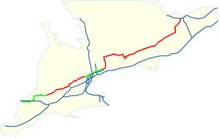
King's Highway 403, or simply Highway 403, is a 400-series highway in the Canadian province of Ontario that travels between Woodstock and Mississauga, branching off from and reuniting with Highway 401 at both ends and travelling south of it through Hamilton and Mississauga. It is concurrent with the Queen Elizabeth Way (QEW) for 22 km (14 mi) from Burlington to Oakville. Although the Highway 403 designation was first applied in 1963 to a short stub of freeway branching off the QEW, the entire route was not completed until August 15, 1997, when the section from Brantford to the then-still independent Town of Ancaster was opened to traffic. The section of Highway 403 between Woodstock and Burlington was formally dedicated as the Alexander Graham Bell Parkway on April 27, 2016.

Ontario Highway 410 Controlled-access highway in Ontario

King's Highway 410, also known as Highway 410 and colloquially as the four-ten, is a 400-series highway in the Canadian province of Ontario that connects Highways 401 and 403 to Brampton. North of Brampton, the freeway connects to Highway 10, which continues north through Caledon as a four-lane undivided highway. The route is patrolled by the Ontario Provincial Police and has a speed limit of 100 km/h (62 mph).

Ontario Highway 416 Controlled-access highway in Ontario

King's Highway 416, commonly referred to as Highway 416 and as the Veterans Memorial Highway, is a 400-series highway in the Canadian province of Ontario that connects the Trans-Canada Highway (Highway 417) in Ottawa with Highway 401 between Brockville and Cornwall. The 76.4-kilometre-long (47.5 mi) freeway acts as an important trade corridor from Interstate 81 between New York and Eastern Ontario via Highway 401, as well as the fastest link between Ottawa and Toronto. Highway 416 passes through a largely rural area, except near its northern terminus where it enters the suburbs of Ottawa. The freeway also serves several communities along its length, notably Spencerville and Kemptville.

The Hanlon Expressway or Hanlon Parkway is a high-capacity at-grade suburban limited-access road connecting Highway 401 with the city of Guelph in the Canadian province of Ontario. The 17 km (11 mi) route travels in a generally north-south direction on the city's west side. It is signed as Highway 6 for its entire length; from Wellington Street to Woodlawn Road it is concurrent with Highway 7. The speed limit alternates between 70 and 80 km/h.

Steeles Avenue

Steeles Avenue is an east–west street that forms the northern city limit of Toronto and the southern limit of York Region in Ontario, Canada. It stretches 77.3 km (48.0 mi) across the western and central Greater Toronto Area from Appleby Line in Milton in the west to the Toronto-Pickering city limits in the east, where it continues east into Durham Region as Taunton Road, which itself extends 58 km (36 mi) across the length of Durham Region to its boundary with Northumberland County.

King's Highway 50, commonly referred to as Highway 50, was a provincially maintained highway in the Canadian province of Ontario. The highway, which was decommissioned in 1998, is still referred to as Highway 50, though it is now made up of several county and regional roads: Peel Regional Road 50, York Regional Road 24 and Simcoe County Road 50. The route began in the north end corner of the former Etobicoke at Highway 27 as Albion Road, and travelled northwest to Highway 89 west of the town of Alliston. En route, it passed through the villages of Bolton, Palgrave and Loretto. The road south of Bolton is becoming increasingly suburban as development encroaches from the east and west; but despite this increasing urbanization, the removal of highway status, and the fact that it runs through the former Albion Township, the Albion Road name has not been extended to follow it outside Toronto.

Mid-Peninsula Highway Cancelled Ontario freeway

The Mid-Peninsula Highway is a proposed freeway across the Niagara Peninsula in the Canadian province of Ontario. Although plans for a highway connecting Hamilton to Fort Erie south of the Niagara Escarpment have surfaced for decades, it was not until The Niagara Frontier International Gateway Study was published by the Ministry of Transportation of Ontario (MTO) in 1998 that serious examination and planning began. The study called for an alternative route to the QEW, which runs through tender fruitlands and is not capable of expansion beyond its current configuration. The land on which studies are being performed for this future freeway is referred to as the Mid-Peninsula Corridor or the Niagara–GTA Corrdior.

Hurontario Street road in Ontario, Canada

Hurontario Street is a roadway running in Ontario, Canada between Lake Ontario at Mississauga and Lake Huron's Georgian Bay at Collingwood. Within Peel Region, it is a major urban thoroughfare within the cities of Mississauga and Brampton, which serves as the divide from which cross-streets are split into East and West, except at its foot in the historic Mississauga neighbourhood of Port Credit. Farther north, with the exception of the section through Simcoe County, where it forms the 8th Concession, it is the meridian for the rural municipalities it passes through. In Dufferin County, for instance, parallel roads are labelled as EHS or WHS for East of Hurontario Street.

King's Highway 10, commonly referred to as Highway 10 is a provincially maintained highway in the Canadian province of Ontario. The highway connects the northern end of Highway 410 just north of Brampton with Owen Sound on the southern shores of Georgian Bay, passing through the towns of Orangeville and Shelburne as well as several smaller villages along the way. It historically followed the Toronto–Sydenham Road, the southern part of which later became Hurontario Street. The section between Orangeville and Primrose was formerly part of Prince of Wales Road, which continues northwards after the highway turns west.

The Bradford Bypass, also known as the Highway 400–404 Link is a proposed east–west 400-series highway in the northern Greater Toronto Area of the Canadian province of Ontario. The approximately 16.2-kilometre (10.1 mi) route is currently undergoing planning and analysis under an environmental impact assessment (EA) by the Ministry of Transportation of Ontario (MTO) and the Government of Ontario. If approved, a new four-lane controlled-access highway would be built between Highway 400 near Bradford in Simcoe County, and Highway 404 near Queensville in York Region. It would serve as a bypass to the north side of Bradford.

References

  1. 1 2 3 Fox, Chris (February 25, 2021). "Mississauga Council Formally Opposes Hwy. 413 as Crombie Warns of 'Disastrous Impact on Environment'". CP24. Retrieved March 15, 2021.
  2. Frisque, Graeme (February 10, 2018). "Wynne Government Kills Plans for GTA West Highway After Lengthy and Expensive Planning Process". Brampton Guardian. Retrieved March 17, 2021.
  3. 1 2 Ministry of Finance (November 15, 2018). "Chapter I, Section C: Respecting Consumers And Families". Ontario Economic Outlook and Fiscal Review (Report). Government of Ontario. p. 73. Retrieved February 17, 2021.
  4. 1 2 3 "Ontario's Proposed Highway 413 is a $6-Billion Sprawl Accelerator". Globe and Mail . February 2021. Retrieved March 17, 2021.
  5. 1 2 Bradley, Dave (February 9, 2018). "Province Scraps Plans for Highway 413". Newstalk 1010 . Retrieved February 17, 2021.
  6. 1 2 WSP. "Frequently Asked Questions – GTA West". GTA West Study. Aecom. Archived from the original on February 9, 2021. Retrieved March 17, 2021.
  7. McKenzie-Sutter, Holly (November 10, 2021). "Ford government shows support for controversial Highway 413 with campaign-style route visit". Global News . Retrieved November 11, 2021.
  8. 1 2 3 4 5 6 7 WSP (August 7, 2020). "Preferred Route Announcement" (PDF). GTA West Study (Press release). Aecom. Retrieved March 15, 2021.
  9. Al-Shibeeb, Dina (August 7, 2020). "Ontario Government Confirms Preferred Route for GTA West Corridor". Vaughan Citizen. Retrieved March 15, 2021.
  10. 1 2 3 4 5 Google (March 15, 2021). "GTA West Corridor – Length and Route" (Map). Google Maps . Google. Retrieved March 15, 2021.
  11. Crawley, Mike (October 16, 2021). "Doug Ford's PCs believe Highway 413 is a winning issue in next election". CBC News . Retrieved January 14, 2022.
  12. "GTA West Transportation Corridor – Route Planning and EA Study – Stage 2 – Presentation to Town of Caledon Council". Aecom. July 7, 2020. Retrieved March 15, 2021.
  13. Abrey, Heather (November 20, 2009). "Hwy 410 Extension Causing Confusion". Caledon Enterprise. North Peel Media Group. Retrieved July 25, 2010.
  14. Al-Shibeeb, Dina (February 22, 2021). "'Shame on Ford government': Vaughan and King Residents Urge York Region to Axe Support for $6B GTA Highway". Vaughan Citizen. Retrieved March 15, 2021.
  15. Paradigm Transportation Solutions Limited (September 20, 2004). Caledon Transportation Needs Study (PDF) (Report). Regional Municipality of Peel. p. 26. Retrieved March 19, 2021.
  16. "Status Report – Bram West Secondary Plan and North West Brampton Future Urban Development Area Corridor Protection Area – Official Plan and Zoning Bylaw Amendments – City of Brampton" (PDF). City of Mississauga. August 30, 2005. Retrieved March 19, 2021.
  17. "By-Law Number 360-2005" (PDF). City of Brampton. November 14, 2005. Retrieved March 17, 2021.
  18. "Overview". Growth Plan for the Greater Golden Horseshoe, 2006. Government of Ontario. Retrieved March 19, 2021.
  19. "Schedule 2". Growth Plan for the Greater Golden Horseshoe 2006. Government of Ontario. Retrieved March 19, 2021.
  20. Ministry of the Environment, Conservation and Parks. "Part A Preparing the Terms of Reference and Class Environmental Assessment". Government of Ontario. Retrieved March 20, 2021.
  21. McCormick Rankin (July 2007). "GTA West Corridor Environmental Assessment Terms of Reference" (PDF). GTA West Study. Aecom. pp. 1–4. Retrieved March 20, 2021.
  22. Ministry of the Environment, Conservation and Parks (March 4, 2008). "Approval of the Terms of Reference for the GTA West Transportation Corridor Environmental Assessment". Government of Ontario. Retrieved March 20, 2021.
  23. "Will Halton Hills Become the Byway for a New Highway?". Burlington Post. June 10, 2010. Retrieved March 22, 2021 via InsideHalton.com.
  24. McCormick Rankin & URS (November 2012). "4.4. Road Based Improvement Alternatives". GTA West Corridor Environmental Assessment Study – Transportation Development Strategy Report (PDF) (Report). Aecom. pp. 45–49. Retrieved March 21, 2021.
  25. "Project Background". New Highway 7 – Kitchener to Guelph. WSP . Retrieved March 22, 2021.
  26. iTrans Consulting (May 2010). Halton–Peel Boundary Area Transportation Study Amended Final Report Executive Summary (PDF) (Report). p. ii. Retrieved March 20, 2021.
  27. City of Brampton Transportation and Transit Master Plan Sustainable Update (PDF) (Report). iTrans Consulting. November 2009. pp. 23–24. Retrieved March 20, 2021.
  28. Tallyn, Lisa (April 27, 2010). "Report Calls for New Freeway and Norval Bypass" (PDF). The Independent. Halton Hills. p. 1. Retrieved March 20, 2021 via OurOntario.ca.
  29. "GTA West Transportation Corridor". The Town of Halton Hills. Retrieved March 20, 2021.
  30. McCormick Rankin & URS (November 2012). "5.8. Summary of Evaluation Findings of 2011/2012 Additional Analysis". GTA West Corridor Environmental Assessment Study – Transportation Development Strategy Report (PDF) (Report). Aecom. p. 158. Retrieved March 21, 2021.
  31. McCormick Rankin & URS (November 2012). "6.4. New / Expanded Roadway Infrastructure". GTA West Corridor Environmental Assessment Study – Transportation Development Strategy Report (PDF) (Report). Aecom. p. 172. Retrieved March 21, 2021.
  32. Planning and Infrastructure Services Committee (March 30, 2015). GTA West Transportation Corridor Route Planning and Environmental Assessment Study, Stage 2 (PDF) (Report). Committee of the Council of The Corporation of the City of Brampton. Retrieved March 22, 2021.
  33. Javed, Noor (January 2, 2015). "Proposed highway to pave parts of Greenbelt proving controversial". Toronto Star. Retrieved March 23, 2021. “We see this as a lose-lose proposal,” said Susan Lloyd Swail, the Greenbelt Program Manager with Environmental Defence. “There will be a loss to the Greenbelt, a loss of farmland, waterways and forests,” said Swail.
  34. "Ontario to Review Greater Toronto Area West Corridor Project". Government of Ontario. December 16, 2015. Retrieved March 17, 2021.
  35. "Advisory Panel Members". GTA West Corridor Review. Ministry of Transportation of Ontario. Retrieved March 20, 2021.
  36. Belgrave, Roger (October 7, 2016). "Ontario Seeks Public Input On Alternatives to Proposed GTA-West Highway". Brampton Guardian. Retrieved March 22, 2021.
  37. Martin-Robbins, Adam (May 1, 2017). "Fate of Future 400-Series Highway Through Vaughan Still Up in Air". Vaughan Citizen. Retrieved March 17, 2021 via YorkRegion.com.
  38. Criscione, Peter (November 8, 2016). "Brampton Wants Province to Revive GTA-West Highway Plans". Brampton Guardian. Retrieved March 22, 2021.
  39. GTA West Advisory Panel (May 29, 2017). GTAW Advisory Panel's Letter (Report). Ministry of Transportation of Ontario. Archived from the original on June 18, 2019. Retrieved March 23, 2021.
  40. GTA West Advisory Panel (May 29, 2017). GTA West Corridor Advisory Panel Report (Report). Ministry of Transportation of Ontario. Archived from the original on June 18, 2019. Retrieved March 23, 2021.
  41. 1 2 Webster, Paul (December 19, 2020). "Doug Ford Plans to Start Building a New Superhighway Near the 401 Next Year. Why Not Move All the Trucks to the 407 Toll Highway Instead?". Toronto Star . Retrieved March 17, 2021.
  42. "Ontario Not Moving Forward with Highway for GTA West Corridor". Government of Ontario. February 9, 2018. Retrieved March 23, 2021.
  43. 1 2 "Plan For The People". Ontario PC Party. Archived from the original on March 22, 2021. Retrieved March 23, 2021.
  44. Grenier, Éric (June 8, 2018). "Doug Ford Promised to Deliver the GTA for the Ontario PCs and That's What He Did". CBC News. Retrieved March 24, 2021.
  45. Frisque, Graeme (June 6, 2019). "Brampton Council Applauds Ford Government's Hwy. 413/GTA West Corridor Reboot". Brampton Guardian. Retrieved March 24, 2021.
  46. Moore, Oliver (November 3, 2019). "Ontario PCs Revive Plans for GTA West Highway Amid Questions of Suitability in Changing Transportation Future". The Globe and Mail. Retrieved March 17, 2021.
  47. 1 2 "Preferred Interchange Locations" (PDF). GTA West Study. September 2019. Retrieved March 29, 2020.
  48. Marychuk, Marta (July 29, 2020). "Caledon Council Hears Options for GTA West Corridor". Caledon Enterprise. Retrieved March 24, 2021 via Toronto.com.
  49. 1 2 3 "Ontario Making Travel Easier Across York, Peel and Halton Regions" (Press release). Government of Ontario. August 7, 2020. Retrieved March 17, 2021.
  50. Frisque, Graeme (November 14, 2019). "Province Says No Timeline Yet for GTA West Highway". Brampton Guardian. Retrieved March 24, 2021.
  51. "GTA West Project". Impact Assessment Agency of Canada . February 18, 2021. Retrieved March 29, 2021.
  52. Bowman, Laura (February 3, 2021). "GTA West – Request for Designation of Project" (PDF). Impact Assessment Agency of Canada. Retrieved March 29, 2021.
  53. "Environmental Groups Ask Ottawa to Intervene on Controversial Highway Projects". BarrieToday.com. Retrieved March 29, 2021.
  54. Chaarani, James (February 27, 2021). "Caledon Requests Federal Environmental Assessment of GTA West Highway: But Do Feds Have Jurisdiction?". Toronto.com. Retrieved March 29, 2021.
  55. Wilkinson, Jonathan (May 3, 2021). "My Statement On the Designation Request for the GTA West Project". Twitter. Retrieved May 3, 2021.
  56. "Minister's Response on the Designation Request for the GTA West Project". Impact Assessment Agency of Canada . May 3, 2021. Retrieved May 3, 2021.
  57. 1 2 Bailey, Ian; Moore, Oliver; Stone, Laura (May 3, 2021). "Environmental concerns spur Ottawa to consider Highway 413 assessment". Globe and Mail . Retrieved November 5, 2021.
  58. Artuso, Antonella (November 4, 2021). "New Highways in Fast Lane". Toronto Sun . p. 7.
  59. 1 2 McGillivray, Kate (February 25, 2021). "Plan for New 400-Series Highway Draws Growing Pressure from Across the GTA to Hit the Brakes". CBC News. Retrieved March 17, 2021.
  60. 1 2 Is Building Highway 413 the Best Option for Moving People & Goods in the GTA West Region? (PDF) (Report). Environmental Defence. August 2020. Archived (PDF) from the original on March 13, 2021. Retrieved July 9, 2021.
  61. 1 2 3 4 McIntosh, Emma (March 12, 2021). "Ford Government's Hwy. 413 Dreams Fade As Another Municipality Pulls Support". National Observer. Retrieved March 18, 2021.
  62. 1 2 "Response to Inaccurate Media Coverage of TRCA's Stance Regarding the Proposed GTA West Highway". Toronto and Region Conservation Authority (TRCA). March 1, 2021. Retrieved March 18, 2021.
  63. "Stop the 413". Environmental Defence. Retrieved March 18, 2021.
  64. 1 2 Webster, Paul (November 24, 2020). "Highway 413: The Opposition Reloads". In the Hills. Retrieved March 18, 2021. "Agricultural land is valued as low as $18,000 an acre, but residential land is easily worth $1 million an acre," says Susan Lloyd Swail, a King City-based land-use planning expert who opposes the highway. “There are hundreds of millions of dollars to be made right now simply by rezoning farmlands around the new freeway into development lands. And there are billions more to be made in the future from developing those lands into ever more residential and industrial sprawl.
  65. Javed, Noor (January 2, 2015). "Proposed Highway to Pave Parts of Greenbelt Proving Controversial". Toronto Star . Retrieved March 17, 2021.
  66. Javed, Noor (January 30, 2015). "GTA West Highway: Forward Thinking or Retro Mistake?". Toronto Star . Retrieved March 17, 2021.
  67. Duranton, Gilles; Turner, Matthew A. (September 4, 2009). "The Fundamental Law of Road Congestion: Evidence from US cities" (PDF). University of Toronto, Department of Economics. Retrieved March 19, 2021.
  68. "Highway 413". Ontario Farmland Trust. October 1, 2020. Retrieved March 18, 2021.
  69. "GTA West Multimodal Transportation Corridor Fact Sheet". Avison Young . 2021. Retrieved March 29, 2021.
  70. Buist, Steve; Javed, Noor; McIntosh, Emma (April 3, 2021). "Friends with benefits? An inside look at the money, power and influence behind the Ford government's push to" . The Toronto Star. ISSN   0319-0781 . Retrieved November 2, 2021. The group of developers own 39 properties covering 3,300 acres that are conservatively valued at nearly half a billion dollars, according to land registry documents. Most of the developers in the group are also prolific PC donors, contributing at least $813,000 to support the party since 2014.
  71. Broadley, Laura (October 15, 2020). "'It's Just Going to Ruin Everything': King, Vaughan Groups Team Up to Fight Hwy. 413". YorkRegion.com. Retrieved March 18, 2021.
  72. Buist, Steve; Javed, Noor; McIntosh, Emma (April 3, 2021). "Friends with benefits? An inside look at the money, power and influence behind the Ford government's push to" . The Toronto Star. ISSN   0319-0781 . Retrieved November 2, 2021. One study commissioned by the previous Liberal government estimated the proposed highway would save drivers a mere 30 to 60 seconds of driving time. The Ministry of Transportation contends that it would save drivers 30 minutes.
  73. "Vaughan Withdraws Support for New 400-Series Highway". 680 News. March 3, 2021. Retrieved March 18, 2021.
  74. "Region of Peel votes to oppose GTA West Highway despite efforts of Brampton & Caledon mayors". Yahoo News Canada. March 12, 2021. Archived from [July 9, 2021 the original] Check |url= value (help) on April 11, 2021.
  75. Pavilons, Mark (April 7, 2021). "King Township Withdraws Support for GTA Corridor". King Weekly Sentinel. Archived from the original on July 10, 2021. Retrieved July 9, 2021 via Yahoo! News Canada.
  76. Wells, Tabitha (November 13, 2020). "'GTA West does not align with Orangeville's priorities': Council opposes Highway 413 through Caledon, Vaughan, Milton". Orangeville.com. Retrieved March 18, 2021.
  77. "Caledon Calls On Province for Public Consultations On Highway 413 Plan". Toronto Star. March 5, 2021. Retrieved March 18, 2021.
  78. "Mississauga Formally Opposes New 400-Series GTA Highway Proposed by Ontario Government". CTV News. February 25, 2021. Retrieved March 20, 2021. The leaders of the NDP, the Green Party and the Liberal Party have also said that they would not proceed with the project if elected.
  79. "NDP Will Scrap Sprawl-Inducing GTA West Highway Plan if Elected in 2022". Yahoo News Canada. January 28, 2021. Archived from the original on March 6, 2021. Retrieved July 9, 2021.
  80. "Ontario Liberals Pledge to Cancel Hwy 413, Build and Repair Schools Instead". CTV News Toronto. March 22, 2021. Retrieved March 22, 2021.
  81. "Toronto City Council Votes to Oppose Provincial Plans for Highway 413 in Northwest GTA". CBC News. Retrieved March 20, 2021.
  82. Hale, Alan S (March 18, 2021). "York Region reconfirms its support of GTA West highway corridor". NewmarketToday.ca. Retrieved March 29, 2021.
  83. "OTA Voices Support for New GTA West Highway". Truck News. March 10, 2021. Retrieved March 20, 2021.
  84. "BILD: GTA West Corridor is a Much Needed Link". Toronto Sun . December 12, 2016. Retrieved March 23, 2021.
  85. Webster, Paul (February 13, 2021). "Doug Ford's Planned Superhighway is a 'slam Dunk' for Developers — But Some Say It Will Be an Economic Disaster". Toronto Star. Retrieved March 23, 2021.
  86. "CUR supports GTA West Corridor EA streamlining". Daily Commercial News. August 31, 2020. Retrieved March 29, 2021. Without the proposed streamlining of the process it would be the year 2023 or beyond before the preliminary design study for the corridor is completed, it is simply taking too long to bring critical infrastructure improvements such as roads, transit, sewers and water to completion, or to ensure serviced sites in built-up urban and greenfield areas are available to meet the demands of new residents and businesses.
  87. Hunt, Geoff (July 12, 2001). "Council Minutes". Peelregion.ca. Regional Municipality of Peel. Archived from the original on April 8, 2021. Retrieved July 9, 2021.
  88. Aecom (April 2012). City of Vaughan Transportation Master Plan – Existing Transportation Conditions, Trends and Future Plans – Appendix D (PDF) (Report). City of Vaughan. p. 10. Retrieved March 23, 2021.
  89. Highway Transfers List – "Who Does What" (Report). Ministry of Transportation of Ontario. June 20, 2001. pp. 4, 13–14.

Route map:

KML file (edithelp)
    KML is not from Wikidata