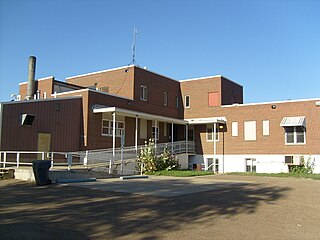
Garfield County is a county located in the U.S. state of Montana. As of the 2020 census, the population was 1,173. Its county seat is Jordan. Garfield County is noteworthy as the site of the discovery and excavation of four of the world's dozen or so major specimens of Tyrannosaurus rex. A cast of the skull of one of these dinosaurs is on display at the Garfield County Museum.
Garfield County is a county located in the U.S. state of Colorado. As of the 2020 census, the population was 61,685. The county seat is Glenwood Springs. The county is named in honor of United States President James A. Garfield. Garfield County is included in the Glenwood Springs, CO Micropolitan Statistical Area, which is also included in the Edwards-Glenwood Springs, CO Combined Statistical Area.

Rifle is a home rule municipality in, and the most populous community of, Garfield County, Colorado, United States. The population was 10,437 at the 2020 census. Rifle is a regional center of the cattle ranching industry located along Interstate 70 and the Colorado River just east of the Roan Plateau, which dominates the western skyline of the town. The town was founded in 1882 by Abram Maxfield, and was incorporated in 1905 along Rifle Creek, near its mouth on the Colorado. The community takes its name from the creek.

Mount Lafayette is a 5,249-foot (1,600 m) mountain at the northern end of the Franconia Range in the White Mountains of New Hampshire, United States. It lies in the town of Franconia in Grafton County, and appears on the New England Fifty Finest list of the most topographically prominent peaks in New England. The mountain's upper reaches are located in the alpine zone, an area where only dwarf vegetation exists due to the harsh climate.

The Grand Mesa National Forest is a U.S. National Forest in Mesa, Delta and Garfield Counties in Western Colorado. It borders the White River National Forest to the north and the Gunnison National Forest to the east. The forest covers most of Grand Mesa and the south part of Battlement Mesa. It has a total area of 346,555 acres. It is managed by the United States Forest Service together with Gunnison National Forest and Uncompahgre National Forest from offices in Delta, Colorado. There are local ranger district offices located in Grand Junction.

Mount Garfield is a mountain located in Grafton County, New Hampshire. The mountain is part of the White Mountains. Mt. Garfield is flanked to the east by South Twin Mountain, and to the southwest along Garfield Ridge by Mount Lafayette.

Galehead Mountain is a mountain located in Grafton County, New Hampshire. The mountain is part of the Twin Range of the White Mountains. Galehead is flanked to the east by South Twin Mountain, and to the west by Mount Garfield. The summit is reached by the Frost Trail which departs from Galehead Hut. There are several ways to reach the hut from one's car, the Gale River Trail from the northwest being the most direct.

Mount Ellen is a mountain located in Garfield County, Utah, United States.

The Garfield Range is a mountain range on Ellesmere Island, Nunavut, Canada. The mountains are made of Paleozoic rocks and rise to heights between 1,067 m (3,501 ft) and 1,433 m (4,701 ft) and are separated by valleys through which flow the major rivers fed by the ice fields and glaciers. Like most of the mountain ranges in the Arctic, it is one of the world's northernmost mountain ranges.

Storm King Mountain is a mountain in the White River National Forest of the Rocky Mountains, 5 miles (8.0 km) northwest of Glenwood Springs, Colorado, in northeastern Garfield County. It is on the north side of the Colorado River and Interstate 70 (I-70), between Glenwood Springs and New Castle.A ski lift at the Copper Mountain Ski Resort is named after the mountain.

Carbonate Mountain is a high mountain summit in the southern Sawatch Range of the Rocky Mountains of North America. The 13,670-foot (4,167 m) thirteener is located in San Isabel National Forest, 5.4 miles (8.7 km) north of the community of Garfield in Chaffee County, Colorado, United States.
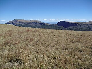
Flat Top Mountain is the highest summit of the Flat Tops in the Rocky Mountains of North America. The prominent 12,361-foot (3,768 m) peak is located in the Flat Tops Wilderness, 19.1 miles (30.7 km) south-southwest of the Town of Oak Creek, Colorado, United States, on the drainage divide between Routt National Forest and White River National Forest. The summit of Flat Top Mountain is the highest point in Garfield County, Colorado.

Garfield is an unincorporated community and a census-designated place (CDP) located in and governed by Chaffee County, Colorado, United States. The population of the Garfield CDP was 27 at the United States Census 2020. The Salida post office serves the area.
North Mamm Peak is a prominent mountain summit on Grand Mesa in the Rocky Mountains of North America. The 11,129-foot (3,392 m) peak is located in White River National Forest, 11.6 miles (18.6 km) south-southwest of the Town of Rifle in Garfield County, Colorado, United States.

Arrow Peak is a high mountain summit in the Grenadier Range of the Rocky Mountains of North America. The 13,809-foot (4,209 m) thirteener is located in the Weminuche Wilderness of San Juan National Forest, 8.7 miles (14.0 km) south-southeast of the Town of Silverton in San Juan County, Colorado, United States.
Garfield Peak is a high mountain summit of the Collegiate Peaks in the Sawatch Range of the Rocky Mountains of North America. The 13,787-foot (4,202 m) thirteener is located 5.6 miles (9.0 km) south-southwest of Independence Pass, Colorado, United States, on the Continental Divide separating San Isabel National Forest and Chaffee County from White River National Forest and Pitkin County. Garfield Peak was named in honor of James A. Garfield, 20th President of the United States.

Mt. Garfield is the high point of the Book Cliffs, east-northeast of Grand Junction, and overlooking the town of Palisade. Two classic hiking trails ascend the mountain. The mountain was named after President James Garfield a year after Garfield's death. The mountain is composed of Mesaverde Group overlaying Mancos Shale.

Mount Garfield is a 13,074-foot-elevation (3,985-meter) mountain summit located in San Juan County, Colorado, United States. It is situated eight miles south of the community of Silverton, in the Weminuche Wilderness, on land managed by San Juan National Forest. It is part of the San Juan Mountains range which is a subset of the Rocky Mountains of North America. Precipitation runoff from the mountain drains into tributaries of the Animas River. The peak can be seen from U.S. Route 550 and the Durango and Silverton Narrow Gauge Railroad. Topographic relief is significant as the west aspect rises over 4,300 feet above the river and railway in approximately one mile. It is set six miles west of the Continental Divide, one mile west of Electric Peak, and three miles east-southeast of Snowdon Peak.

Snowdon Peak is a 13,077-foot-elevation (3,986-meter) mountain summit located in San Juan County, Colorado, United States. It is situated seven miles south of the community of Silverton, in the Weminuche Wilderness, on land managed by San Juan National Forest. It is part of the San Juan Mountains range which is a subset of the Rocky Mountains of North America, and is set nine miles west of the Continental Divide. Topographic relief is significant as the east aspect rises 4,300 feet above the Animas River in approximately 1.5 mile. Neighbors include Mount Garfield three miles to the east-southeast, and Twilight Peak, which is the nearest higher peak, 3.7 miles to the south-southwest. This mountain can be seen from U.S. Route 550. The mountain is named after Snowdon, the highest mountain in Wales.

Electric Peak is a 13,292-foot-elevation (4,051-meter) mountain summit located in San Juan County, Colorado, United States. It is situated eight miles south of the community of Silverton, in the Weminuche Wilderness, on land managed by San Juan National Forest. It is part of the Needle Mountains which are a subset of the San Juan Mountains, which in turn is a subset of the Rocky Mountains. Precipitation runoff from the mountain drains into tributaries of the Animas River. The peak can be seen from U.S. Route 550 and the Durango and Silverton Narrow Gauge Railroad. Topographic relief is significant as the west aspect rises over 4,500 feet above the river and railway in approximately two miles. It is set five miles west of the Continental Divide, and one mile east of Mount Garfield. The mountain's name, which has been officially adopted by the United States Board on Geographic Names, was in use before 1906 when Henry Gannett published it in the Gazetteer of Colorado.

