Garrison, Maryland

Last updated
Garrison, Maryland
2016-07-12 11 05 11 View east along Maryland State Route 130 (Greenspring Valley Road) at Turnlee Road in Garrison, Baltimore County, Maryland.jpg
Greenspring Valley Road at Turnlee Road in Garrison, Maryland
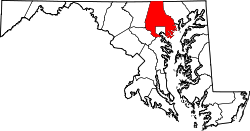
Baltimore County Maryland Incorporated and Unincorporated areas Garrison Highlighted.svg
Location of Garrison, Maryland
Coordinates: 39°24′4″N76°45′4″W / 39.40111°N 76.75111°W / 39.40111; -76.75111 Coordinates: 39°24′4″N76°45′4″W / 39.40111°N 76.75111°W / 39.40111; -76.75111
CountryFlag of the United States.svg United States
State Flag of Maryland.svg  Maryland
County Flag of Baltimore County, Maryland.svg Baltimore
Area
[1]
  Total3.16 sq mi (8.19 km2)
  Land3.16 sq mi (8.18 km2)
  Water0.00 sq mi (0.01 km2)
Elevation
443 ft (135 m)
Population
 (2020)
  Total9,487
  Density3,004.12/sq mi (1,159.76/km2)
Time zone UTC−5 (Eastern (EST))
  Summer (DST) UTC−4 (EDT)
ZIP code
21055
Area code 410
FIPS code 24-31625
GNIS feature ID0590284

Garrison is a census-designated place (CDP) in Baltimore County, Maryland, United States, adjacent to Owings Mills. It consists mainly of the McDonogh area and Valley Centre. The population was 8,823 at the 2010 census. [2]

Contents

Geography

Garrison is located at 39°24′4″N76°45′4″W / 39.40111°N 76.75111°W / 39.40111; -76.75111 (39.401055, 76.751073). [3]

According to the United States Census Bureau, the CDP has a total area of 3.2 square miles (8.2 km2), of which 0.12% is water.

Demographics

Historical population
CensusPop.
1990 5,045
2000 7,96958.0%
2010 8,82310.7%
2020 9,4877.5%
source: [2] [4]

As of the census [5] of 2000, there were 7,969 people, 3,459 households, and 1,940 families residing in the CDP. The population density was 2,551.5 inhabitants per square mile (985.1/km2). There were 3,696 housing units at an average density of 1,183.4 per square mile (456.9/km2). The racial makeup of the CDP was 77.54% White, 17.09% African American, 0.13% Native American, 3.35% Asian, 0.01% Pacific Islander, 0.92% from other races, and 0.97% from two or more races. Hispanic or Latino of any race were 2.27% of the population. In 2000, 14% of Garrison residents identified as being of Russian American heritage. This was the second highest percentage of Russian Americans of any place in Maryland after Pikesville. [6] The majority of them are of Jewish ancestry. 2% of Garrison's residents were of Ukrainian descent and 1% were descended from other Eastern European countries. 8% were German, 7% Polish, 5% Irish, 4% English, 3% Italian, 2% Lithuanian, and 2% French. [7]

There were 3,459 households, out of which 25.7% had children under the age of 18 living with them, 42.0% were married couples living together, 10.8% had a female householder with no husband present, and 43.9% were non-families. 35.5% of all households were made up of individuals, and 6.3% had someone living alone who was 65 years of age or older. The average household size was 2.19 and the average family size was 2.90.

In the CDP, the population was spread out, with 22.0% under the age of 18, 10.3% from 18 to 24, 34.4% from 25 to 44, 23.5% from 45 to 64, and 9.8% who were 65 years of age or older. The median age was 34 years. For every 100 females, there were 98.3 males. For every 100 females age 18 and over, there were 94.9 males.

The median income for a household in the CDP was $56,520, and the median income for a family was $62,171. Males had a median income of $45,286 versus $37,472 for females. The per capita income for the CDP was $36,236. About 4.6% of families and 5.8% of the population were below the poverty line, including 7.4% of those under age 18 and 9.3% of those age 65 or over.

Notable people

Related Research Articles

Miami Gardens was a census-designated place (CDP) in Broward County, Florida, United States. The population was 2,706 at the 2000 census.

<span class="mw-page-title-main">Bunche Park, Florida</span> Neighborhood of Miami Gardens in Miami-Dade, Florida, United States

Bunche Park is a neighborhood in Miami Gardens, Florida, United States. It was formerly a census-designated place.

<span class="mw-page-title-main">Coral Terrace, Florida</span> Census-designated place in Florida, United States

Coral Terrace is a suburban unincorporated community and census-designated place (CDP) in Miami-Dade County, Florida, United States. The population was 23,142 at the 2020 census, down from 24,376 in 2010.

<span class="mw-page-title-main">Golden Glades, Florida</span> Census-designated place in Florida, United States

Golden Glades is a census-designated place (CDP) in Miami-Dade County, Florida, United States. The population was 32,499 at the 2020 census.

<span class="mw-page-title-main">Ives Estates, Florida</span> Census-designated place in Florida, United States

Ives Estates is a census-designated place (CDP) in Miami-Dade County, Florida. The population was 25,005 at the 2020 census, up from 19,525 in 2010.

<span class="mw-page-title-main">Leisure City, Florida</span> CDP in Florida, United States

Leisure City is a census-designated place (CDP) in Miami-Dade County, Florida, United States, that includes the smaller, older community of Modello in its northwestern section. The population was 22,152 at the 2000 census. Leisure City is most notable for the Coral Castle Museum, located in the Modello area.

<span class="mw-page-title-main">Naranja, Florida</span> CDP in Florida, United States

Naranja is a census-designated place (CDP) in Miami-Dade County, Florida, United States. Many orange groves were once located in this area, so the community name came from the Spanish word for orange, "naranja", but the actual pronunciation is (Na-Ran-Jah) among the local residents, which is the Portuguese pronunciation. Naranja was also a stop for the Florida East Coast Railroad that once ran through this area. The population was 8,303 at the 2010 census.

<span class="mw-page-title-main">Olympia Heights, Florida</span> Neighborhood in Miami-Dade, Florida, United States

Olympia Heights is a census-designated place in Miami-Dade County, Florida, United States. The population was 13,488 at the 2010 census.

<span class="mw-page-title-main">Princeton, Florida</span> CDP & unincorporated community in Florida, United States

Princeton is a census-designated place (CDP) and unincorporated community in Miami-Dade County, Florida, United States. The population was 22,038 at the 2010 census.

<span class="mw-page-title-main">Richmond Heights, Florida</span> CDP in Florida, United States

Richmond Heights is a census-designated place (CDP) in Miami-Dade County, Florida, United States. The population was 8,541 at the 2010 census.

<span class="mw-page-title-main">Tamiami, Florida</span> CDP in Florida, United States

Tamiami is a census-designated place (CDP) in Miami-Dade County, Florida, United States. The population was 55,271 at the 2010 census.

<span class="mw-page-title-main">The Hammocks, Florida</span> CDP in Florida, United States

The Hammocks is an unincorporated census-designated place in Miami-Dade County, Florida, United States. The population was 51,003 at the 2010 census.

<span class="mw-page-title-main">West Little River, Florida</span> CDP in Miami-Dade County, Florida, US

West Little River is a census-designated place (CDP) in Miami-Dade County, Florida, United States. The population was 34,699 at the 2010 census.

<span class="mw-page-title-main">Crownsville, Maryland</span> Census-designated place in Maryland, United States

Crownsville is a census-designated place (CDP) in Anne Arundel County, Maryland, United States. The population was 1,757 at the 2010 census. It hosts the Anne Arundel County Fair each September, as well as the annual Maryland Renaissance Festival for several summer weekends. A state psychiatric hospital was formerly in Crownsville. The area offers waterfront scenery and easy access to urban metropolitan areas and culture.

<span class="mw-page-title-main">Lochearn, Maryland</span> Census-designated place in Maryland, United States

Lochearn is an unincorporated community and census-designated place in Baltimore County, Maryland, United States, located immediately to the west of the City of Baltimore. Per the 2020 census, the population was 25,511.

<span class="mw-page-title-main">Pikesville, Maryland</span> Census-designated place in Maryland, United States

Pikesville is a census-designated place (CDP) in Baltimore County, Maryland, United States. Pikesville is just northwest of the Baltimore city limits. It is the northwestern suburb closest to Baltimore.

<span class="mw-page-title-main">Randallstown, Maryland</span> Census-designated place in Maryland, United States

Randallstown is an unincorporated community and census-designated place in Baltimore County, Maryland, United States. It is named after Christopher and Thomas Randall, two 18th-century tavern-keepers. At that time, Randallstown was a tollgate crossroads on the Liberty Turnpike, a major east–west thoroughfare. Today it is a suburb of Baltimore, with a population of 33,655 as of the 2020 census. In the 1990s, Randallstown transitioned to a majority African American community.

<span class="mw-page-title-main">Rosedale, Maryland</span> Census-designated place in Maryland, United States

Rosedale is an unincorporated community and census-designated place in Baltimore County, Maryland, United States. The population was 19,257 at the 2010 United States Census.

<span class="mw-page-title-main">Eldersburg, Maryland</span> Census-designated place in Maryland, United States

Eldersburg is an unincorporated community and census-designated place (CDP) in Carroll County, Maryland, United States. The population was 30,531 at the 2010 census.

<span class="mw-page-title-main">Jarrettsville, Maryland</span> Census-designated place in Maryland, United States

Jarrettsville is an unincorporated community and census-designated place (CDP) in Harford County, Maryland, United States. The population was 2,888 at the 2020 census.

References

  1. "2020 U.S. Gazetteer Files". United States Census Bureau. Retrieved April 26, 2022.
  2. 1 2 "Profile of General Population and Housing Characteristics: 2010 Demographic Profile Data (DP-1): Garrison CDP, Maryland". United States Census Bureau . Retrieved February 23, 2012.
  3. "US Gazetteer files: 2010, 2000, and 1990". United States Census Bureau. 2011-02-12. Retrieved 2011-04-23.
  4. "CENSUS OF POPULATION AND HOUSING (1790-2000)". U.S. Census Bureau . Retrieved 2010-07-17.
  5. "U.S. Census website". United States Census Bureau . Retrieved 2008-01-31.
  6. "Ancestry Map of Russian Communities". Epodunk.com. Retrieved 2015-04-16.
  7. "Garrison, MD, Ancestry & Family History". Epodunk.com. Retrieved 2015-04-16.