
Scott County is a county located in the far southwestern part of the U.S. state of Virginia, on the border with Tennessee. As of the 2020 census, the population was 21,576. Its county seat is Gate City. Scott County was formed by an act of the General Assembly on November 24, 1814, from parts of Washington, Lee, and Russell counties and was named for Virginia-born General Winfield Scott. Scott County is part of the Kingsport–Bristol–Bristol, TN-VA Metropolitan Statistical Area, which is a component of the Johnson City–Kingsport–Bristol, TN-VA Combined Statistical Area, commonly known as the "Tri-Cities" region. The current County Administrator is Freda Russell Starnes.

Pickens County is a county in the Northwest region of the U.S. state of Georgia. As of the 2020 census, the population was 33,216. The county seat is Jasper. Pickens County is part of the Atlanta-Sandy Springs-Roswell, Georgia metropolitan statistical area.
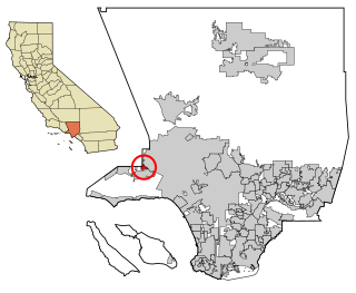
Hidden Hills is a city and gated community in the Santa Monica Mountains region of Los Angeles County, California. It is located next to the cities of Los Angeles and Calabasas. The population was 1,725 as of 2020.

North Druid Hills, also known as Briarcliff or Toco Hills, is an unincorporated community and census-designated place in DeKalb County, Georgia, United States. The population was 20,385 in 2020. The commercial center of the area is the Toco Hill Shopping Center, located near the intersection of North Druid Hills Road and LaVista Road.
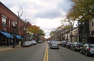
Melrose is a city located in the Greater Boston metropolitan area in Middlesex County, Massachusetts, United States. Its population as of the 2020 census was 29,817. It is a suburb located approximately seven miles north of Boston. It is situated in the center of the triangle created by Interstates 93, 95 and U.S. Route 1.
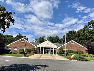
North Hills is a village in the Town of North Hempstead in Nassau County, on the North Shore of Long Island, in New York, United States. The population was 5,464 at the time of the 2020 census.

Levittown is a census-designated place (CDP) and planned community in Bucks County, Pennsylvania, United States. It is part of the Philadelphia metropolitan area. The population was 52,699 at the 2020 census, down from 52,983 at the 2010 census.
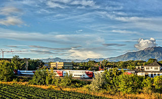
Layton (/ˈleɪʔɪn/) is a city in Davis County, Utah, United States. It is part of the Ogden-Clearfield Metropolitan Statistical Area. As of the 2020 census, the city had a population of 81,773, with 2022 Census Bureau estimates showing an increase to 82,601. 2024 estimates place Layton's population at 87,392. Layton is the most populous city in Davis County and the ninth most populous in Utah.

Yerba Buena Island sits in San Francisco Bay within the borders of the City and County of San Francisco. The Yerba Buena Tunnel runs through its center and connects the western and eastern spans of the San Francisco–Oakland Bay Bridge, linking the city with Oakland, California. Treasure Island is connected by a causeway to Yerba Buena Island. According to the United States Census Bureau, Yerba Buena Island and Treasure Island together have a land area of 0.901 square miles (2.33 km2) with a total population of 2,500 as of the 2010 census.

New Windsor is a town in Orange County, New York, United States. The population was 27,805 at the 2020 census. It is located on the eastern side of the county and is adjacent to the Hudson River and the City of Newburgh.

Golden Gate Park is an urban park between the Richmond and Sunset districts of San Francisco, California, United States. It is the second-largest park in the city, containing 1,017 acres (412 ha), and the third-most visited urban park in the United States, with an estimated 24 million visitors annually.

Crown Hill Cemetery is a historic rural cemetery located at 700 West 38th Street in Indianapolis, Marion County, Indiana. The privately owned cemetery was established in 1863 at Strawberry Hill, whose summit was renamed "The Crown", a high point overlooking Indianapolis. It is approximately 2.8 miles (4.5 km) northwest of the city's center. Crown Hill was dedicated on June 1, 1864, and encompasses 555 acres (225 ha), making it the third largest non-governmental cemetery in the United States. Its grounds are based on the landscape designs of Pittsburgh landscape architect and cemetery superintendent John Chislett Sr and Prussian horticulturalist Adolph Strauch. In 1866, the U.S. government authorized a U.S. National Cemetery for Indianapolis. The 1.4-acre (0.57 ha) Crown Hill National Cemetery is located in Sections 9 and 10.

Colington Island is an island located to the west of Kill Devil Hills in Dare County, North Carolina, United States. The island is located at the converging point of Albemarle Sound, Currituck Sound, Croatan Sound, and Roanoke Sound. While it is commonly referred to as one island, there are actually two separate islands, Big Colington Island and Little Colington Island. Colington Harbour is a gated community located on Big Colington Island.

The Golden Gate National Recreation Area (GGNRA) is a U.S. National Recreation Area protecting 82,116 acres (33,231 ha) of ecologically and historically significant landscapes surrounding the San Francisco Bay Area. Much of the park is land formerly used by the United States Army. GGNRA is managed by the National Park Service and is the second-most visited unit of the National Park system in the United States, with more than 15.6 million visitors in 2022. It is also one of the largest urban parks in the world, with a size two-and-a-half times that of the consolidated city and county of San Francisco.

Russell Township is one of the sixteen townships of Geauga County, Ohio, United States. As of the 2020 census the population was 5,404.
Inwood is a gated neighborhood located in far north-central San Antonio, Texas, United States. Nestled in the wooded, hilly Texas Hill Country, Inwood saw rapid growth and housing construction during the early to mid-1990s. This growth coincided with the rapid growth of the city's North Side as a whole over the last 15 years.

Aoba Castle is a Japanese castle located in Sendai, Miyagi Prefecture. Throughout the Edo period, Aoba Castle was home to the Date clan, daimyō of Sendai Domain. The castle was also known as Sendai-jō (仙台城) or as Gojō-rō (五城楼). In 2003, the castle ruins were designated a National Historic Site.
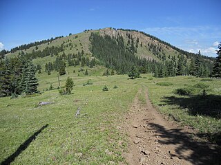
The Cochetopa Hills are a mountain range on the Continental Divide in Saguache County, Colorado, United States. The Cochetopa Hills are a sub-range of the San Juan Mountains and are located in the Gunnison National Forest and Rio Grande National Forest. The range extends from Marshall Pass southwest 50 miles (80 km) along the winding crest of the divide to Saguache Park. The high point of the Cochetopa Hills is Long Branch Baldy at an elevation of 11,974 feet (3,650 m).

Adobe Creek, historically San Antonio Creek, is a 14.2-mile-long (22.9 km) northward-flowing stream originating on Black Mountain in the Santa Cruz Mountains. It courses through the cities of Los Altos Hills, Los Altos, and Palo Alto on its way to the Palo Alto Flood Basin and thence to southwestern San Francisco Bay in Santa Clara County, California, United States. Historically, Adobe Creek was a perennial stream and hosted runs of steelhead trout entering from the Bay, but these salmonids are now blocked by numerous flood control structures, including a tidal gate at the creek's mouth and a long concretized rectangular channel culminating in an impassable drop structure at El Camino Real. The co-founders of Adobe Systems both lived on Adobe Creek.
Hawk Hill is a 923-foot (281 m) peak in the Marin Headlands, just north of the Golden Gate Bridge and across the Golden Gate strait from San Francisco, California. The hill is within the Golden Gate National Recreation Area.


