Buildings
| Name | Location | Photograph | Built | Notes |
|---|---|---|---|---|
| Entrance Gates | Aigburth Road 53°22′30″N2°56′13″W / 53.37509°N 2.93708°W |  | c. 1870 | This formed the entrance to Sefton Park from Aigburth Road, designed by Lewis Hornblower and Édouard André in Gothic style. In the centre is a screen containing the Liverpool coat of arms. This is flanked by granite piers, and three-bay arcades. On the top is a pavilion roof with iron cresting. On each side of the screen are two granite gate piers, with stone capitals and caps. The granite columns were removed from St George's Hall in the 1850s. [3] [4] |
| Gate piers, St Anne's Church | Aigburth Road 53°22′11″N2°55′49″W / 53.36963°N 2.93032°W |  | 1832 | The gate piers were designed by Cunningham and Holme, who also designed the church. They are in two pairs, constructed in stone, and are in Neo-Norman style. They are octagonal, with features including arcading, corbels, and finials. [5] [6] |
| Sefton Park Library | Aigburth Road 53°22′43″N2°56′50″W / 53.3786°N 2.9473°W |  | 1911 | This was the last of the branch libraries designed by Thomas Shelmerdine, and is in Tudor Revival style. The ground floor is in stone, partly roughcast, and the upper parts are timber-framed. It has large brick chimneystacks. The library was opened by Andrew Carnegie, and contains a plaque to commemorate this. [7] [8] |
| Barclays Bank | 301 Aigburth Road, 2 Ashfield Road 53°22′24″N2°56′02″W / 53.3733°N 2.9339°W |  | 1902 | This was designed by Willink and Thicknesse for the Bank of Liverpool. It is in red brick with stone dressings and has a slate roof. The bank is in two storeys with and attic, and has two bays facing each road, with a canted bay on the corner between them. Its features include large voussoirs above the ground floor windows, shaped gables, and an octagonal turret on the corner, with oculi and a copper cap. [9] [10] |
— | 34 Alexandra Drive 53°22′49″N2°56′59″W / 53.3804°N 2.94973°W | — | 1860s | The house, which was later extended and used for other purposes, is in cream, brown and yellow brick with dressings in sandstone and a slate roof. It is in Gothic Revival style, and has two storeys, attics and a basement, and a principal front of seven bays. There is a rich scheme of internal decoration, which has been retained. [11] |
| Presbytery, St Clare's Church | Arundel Avenue 53°23′28″N2°56′12″W / 53.3912°N 2.9366°W | 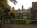 | 1890 | The presbytery was designed by Leonard Stokes, who also designed the church. It is in brick with a slate roof, and is attached to the northeast corner of the chancel. The building is in two storeys with casement windows, and is simply detailed. [12] [13] |
| Bark Hill 53°22′14″N2°55′11″W / 53.3705°N 2.9196°W | Barkhill Road |  | Early 19th century | The house, which was later extended and became part of a college, is in stuccoed brick with slate roofs, two storeys and basements. The original house has five bays, with a service wing to the west of eight bays, to which an attic storey was later added, and a later three-bay wing to the east. The middle bay of the original house is a full-height bow, the ground floor forming an entrance portico with pilasters, an entablature, and a dentilled cornice. The block has a plinth with corner pilasters, a moulded architrave between the floors, an eaves band, a moulded cornice, and a parapet. Most of the windows are mullioned and transomed sashes. [14] |
| Four entrance piers | Fulwood Park 53°22′28″N2°56′15″W / 53.3744°N 2.9375°W |  | c. 1840 | The gate piers stand at the entrance to Fulwood Park, They are in red sandstone, The outer two have a square plan, the other two are octagonal with a cornice and a cap. The gates are no longer present. [15] |
| Lodge | 1A Fulwood Park 53°22′28″N2°56′15″W / 53.37446°N 2.93738°W |  | c. 1840 | The lodge stands at the entrance to the private estate of Fulwood Park. It is built in sandstone, and has a stone slate roof. The entrance front is in three bays. The central bay projects forward under a gable and has two storeys. The lateral bays are in one storey, the left-hand bay containing a doorway. There are hood moulds over the doorway and the windows. To the southeast of the house is a garden gate enclosed in a stone ogee-headed arch flanked by columns, above which is a parapet with four trefoil openings. [16] [17] |
— | 3 Fulwood Park 53°22′25″N2°56′12″W / 53.3736°N 2.9368°W |  | c. 1840 | A stuccoed house with a slate roof, later converted into flats. It is in two storeys with an attic, and has a front of five irregular bays. The second and fourth bays project forward. At the top of the building is a frieze and a cornice. The windows are sashes, those in the upper floor with arcaded balconies. In the fourth bay is a Tuscan porch with a balcony. [16] [18] |
— | 4 Fulwood Park 53°22′22″N2°56′21″W / 53.3729°N 2.9391°W |  | c. 1840 | An asymmetrical stuccoed house with a slate roof. It has two storeys and a six-bay front, the fourth bay projecting forward with a canted bay window. The fifth and sixth bays form a bow window. In the ground floor the windows are casements, and in the upper floor they are sashes. [16] [19] |
— | 5A and 5B Fulwood Park 53°22′24″N2°56′14″W / 53.3733°N 2.9373°W |  | c. 1840 | This originated as a single house, later divided into two houses. It is stuccoed, in one and two storeys, and has a seven-bay front. At the top of the building is a cornice and a parapet. The windows are sashes. In the second bay is a recessed porch with an Ionic colonnade and a balustrade. The fourth bay projects forward under a pediment. In the sixth bay is a Doric porch. [16] [20] |
| Parklea | 6 Fulwood Park 53°22′21″N2°56′22″W / 53.3726°N 2.9394°W |  | c. 1840 | A stuccoed house with a hipped slate roof. It has an L-shaped plan, with two storeys and a three-bay front, the central bay protruding forward. The windows in the ground floor are round-headed, those in the upper floor have architraves and balconies. There is a central entrance with a fanlight. [16] [21] |
— | 8 Fulwood Park 53°22′18″N2°56′25″W / 53.3718°N 2.9403°W |  | c. 1840 | A stuccoed house with a hipped slate roof. It has two storeys with four bays on the front and three on the sides. The end bay is recessed, and the windows are sashes. In the second bay is an entrance with a Doric porch with an architrave. [16] [22] |
— | 9 and 9A Fulwood Park 53°22′20″N2°56′19″W / 53.3721°N 2.9387°W |  | c. 1840 | This originated as a single house, later divided into two houses. The building is stuccoed with slate roofs. It is symmetrical, in two storeys, and has five bays. The second and fourth bays project forward, and the end bays are recessed. The windows are sashes with architraves. At the top of the building are a frieze, a cornice, and a parapet. [16] [23] |
| Osborne House | 13 Fulwood Park 53°22′15″N2°56′25″W / 53.3708°N 2.9402°W |  | c. 1840 | A stuccoed house with a slate roof, it has two storeys and a five-bay front, the two end bays on each side projecting forward under a pediment. At the top of the building is an entablature. The entrance is in the second bay, and in the fifth bay is a long stair-window. The windows are sashes with architraves. On the side is a porch with Tuscan pilasters. [16] [24] |
— | 15 Fulwood Park 53°22′12″N2°56′29″W / 53.3699°N 2.9413°W |  | c. 1840 | A stuccoed house with a slate roof, it has two storeys and a five-bay front. In the fifth bay is a two-storey canted bay window. The windows are sashes with architraves. The third and fourth bays contain a four-bay porch with a colonnade. [16] [25] |
— | 17 and 17A Fulwood Park 53°22′11″N2°56′30″W / 53.3696°N 2.9417°W |  | c. 1840 | A stuccoed house with a slate roof, it has two storeys and a five-bay front. The first two bays have a one-bay forward projection, and the ground floor window in the fifth bay also projects. Above the ground floor is a cornice. At the top of the building is an entablature. The windows are sashes with architraves. The porch has a four-bay colonnade with a pediment. [16] [26] |
— | 19 Fulwood Park 53°22′09″N2°56′32″W / 53.3692°N 2.9421°W |  | c. 1840 | A stuccoed house with a slate roof. It has three storeys and a five-bay front. The first bay projects forward and contains a two-storey canted bay window. At the top of the house is a frieze, and a cornice. The windows are casements with architraves. There is also a six-bay colonnade, and a 20th-century extension. [16] [27] |
— | 21 Fulwood Park 53°22′08″N2°56′33″W / 53.3688°N 2.9426°W | 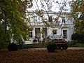 | c. 1840 | A stuccoed house with a slate roof. It has two storeys and a five-bay front, the first two bays being recessed. At the top of the building is a frieze, a cornice, and a panelled parapet. The windows are sashes with architraves. The porch has a four-bay colonnade. [16] [28] |
— | 23 and 25 Fulwood Park 53°22′05″N2°56′36″W / 53.3681°N 2.9432°W |  | c. 1840 | A pair of houses with two storeys, each house having a four-bay front. The first, third, sixth and eighth bays project forward under gables with undulating bargeboards. The windows are sashes. Both houses have Tudor arched entrances. No 23 has a canted porch with a plain parapet, and No 25 has a gabled porch. [16] [29] |
| Greenbank Lodge | Greenbank Drive 53°23′23″N2°55′46″W / 53.38982°N 2.92940°W |  | 1878 | A lodge to Sefton Park designed by Lewis Hornblower and Édouard André. It is in red brick with stone dressings and a slate roof. The lodge has two storeys, the upper storey being half-timbered. There are three bays, the outer two bays projecting forward under gables with decorative bargeboards. The windows are mullioned and transomed, and there is an oriel window in the first bay. On the left side are two half-dormers. [3] [30] |
| Gateway | Hadassah Grove 53°22′49″N2°56′40″W / 53.38039°N 2.94456°W | — | 1840s | An entrance, later blocked, consisting of a segmental-headed stone arch. It incorporates paired pilasters and a cornice, and is gabled. [31] [32] |
— | 2 Hadassah Grove 53°22′51″N2°56′41″W / 53.3809°N 2.9448°W |  | 1840s (probable) | A brick house with stone dressings and a slate roof. It has two storeys and three bays, with pilasters between the bays. All the windows have wedge lintels and are sashes. At the top of the house is a cornice and a frieze. In the first bay is a single-storey canted bay window. [31] [33] |
— | 4 and 6 Hadassah Grove 53°22′51″N2°56′40″W / 53.3808°N 2.9445°W |  | 1840s (probable) | Two brick houses with stone dressings and slate roofs. They are in two storeys, and each house has three bays with angle pilasters. The windows have wedge lintels and are sashes. The central entrances, and the windows above them, have architraves and consoled cornices. [31] [34] |
— | 7 and 9 Hadassah Grove 53°22′52″N2°56′41″W / 53.3812°N 2.9448°W |  | 1840s (probable) | Two brick houses with slate roofs. They are in two storeys, and each house has three bays. All the windows have wedge lintels and most are sashes, while two are casements. Each central entrance has panelled pilasters, a frieze and a cornice. [31] [35] |
— | 8 and 10 Hadassah Grove 53°22′51″N2°56′40″W / 53.3807°N 2.9444°W |  | 1840s (probable) | Two brick houses with stone dressings and a hipped slate roof. They are in two storeys, and each house has three bays. Along the top of the house is a cornice and a frieze. The windows have wedge lintels and are sashes. Both houses have ground floor canted bay windows. [31] [36] |
— | 11 and 13 Hadassah Grove 53°22′52″N2°56′41″W / 53.3811°N 2.9446°W |  | 1840s (probable) | Two stuccoed houses with a slate roof, in two storeys and three bays. Along the top of the building is a cornice and a frieze. The windows are all sashes. Both houses have a canted bay window, and the entrances are flanked by pilasters. [31] [37] |
— | 14 Hadassah Grove 53°22′50″N2°56′41″W / 53.3805°N 2.9446°W |  | 1840s (probable) | A brick house with stone dressings and a slate roof. It has two storeys and three bays, with pilasters and dosserets between the bays. All the windows have wedge lintels and are sashes. At the top of the house is a cornice. The central round-headed doorway has a Doric doorcase with fluted columns, a reeded frieze, and a fanlight. [31] [38] |
— | 17 Hadassah Grove 53°22′51″N2°56′38″W / 53.3808°N 2.9440°W |  | 1840s (probable) | A brick house with stone dressings and a slate roof. It has two storeys, with an entrance front of three bays and two bays facing the street. The windows have wedge lintels and are sashes. On the front is a verandah, behind which is a doorway with an architrave and a consoled cornice. Attached to the house is a stone screen. This has a central entrance with flanking panelled pilasters and gabled finials. [31] [39] |
— | 19 Hadassah Grove 53°22′49″N2°56′40″W / 53.3804°N 2.9444°W |  | 1840s (probable) | A brick house with stone dressings and a slate roof. It has two storeys, with an entrance front of three bays and two bays facing the street. The windows have wedge lintels and are sashes. The entrance is round-headed with a Doric doorcase. There is an attached screen wall containing an entrance with pilasters and finials. [40] |
| The Bridge | Ibbotsons Lane 53°22′54″N2°55′49″W / 53.3817°N 2.9304°W | — | c. 1880 | A brick house with stone dressings and a slate roof. It has two storeys with an attic, and an entrance front of three bays. On each side of the entrance is a rectangular bay window. The windows are mullioned and transomed. The entrance is buttressed, and above it is an oriel window. The gables contain timbering and pargeted panels. [41] |
| Albert public house | Lark Lane 53°22′54″N2°56′42″W / 53.3817°N 2.9449°W |  | 1873 | A public house built for the brewer Robert Cain. It is a stuccoed building with a slate roof, in two storeys and an attic. There are five bays on Lark Lane, four on Pelham Grove, and a canted bay between them. The main entrance is in the canted bay, above which is a diapered panel, and a gable inscribed with "THE ALBERT". Other features include an oriel window, and a canted two-storey bay window with a finial. Included in the designation are four lamp holders. [31] [42] |
| Gate | Lark Lane 53°22′57″N2°56′38″W / 53.3826°N 2.9438°W |  | c. 1870 | Four stone gate piers at an entrance to Sefton Park in Gothic style, probably designed by Lewis Hornblower and Édouard André. The piers are square in section, with foliated cornice s and pyramidal caps. The inner piers have lanterns, and the outer piers have fleurons. [3] [43] |
— | 63 Lark Lane 53°22′52″N2°56′46″W / 53.3811°N 2.9462°W |  | 1884 | This originated as the Christ Church Institute, and was later converted into a restaurant. It is built in brick and timber framing, with a tiled roof. It has two storeys with an attic, and a three-bay front. The ground floor has a central window, with entrances in the lateral bays. The upper storey is jettied, with a clock above the central window. The attic is further jettied, and contains panels with stencilled decoration. The windows are casements. [31] [44] |
| Christ Church | Linnet Lane 53°23′05″N2°56′55″W / 53.3848°N 2.9486°W |  | 1867–71 | The church was designed by Culshaw and Sumners in Decorated style. It is constructed in stone, with slate roofs. It consists of a nave with a clerestory, aisles, a chancel with a south vestry and a north tower with a broach spire. At the west end are diagonal corner porches. The nave has a hammerbeam roof. [45] [46] |
| Iron Bridge | Mossley Hill Drive 53°22′52″N2°55′54″W / 53.38120°N 2.93160°W | 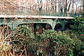 | c. 1870 | A cast iron bridge caring the road over a steam and a ravine designed by Lewis Hornblower and Édouard André. Octagonal columns support lattice girders. At the ends are brick piers; they have stone cornices and ornamental iron lamps. [47] [48] |
| Gledhill | 1 Mossley Hill Drive 53°23′03″N2°55′56″W / 53.3843°N 2.9323°W | — | 1881 | A house designed by James Francis Doyle, built in red brick with sandstone dressings, some timber framing, and a tiled roof. It is asymmetrical in an irregularly-shaped L-plan, it has two storeys with attics, and an irregular arrangement of bays. The windows are mullioned and transomed. Features include very tall chimneys, gables with pargeted panels, an oriel window, dormers, a two-storey polygonal bay window, and an entrance with a four-centred arch. [49] [50] |
— | 2 Mossley Hill Drive 53°23′02″N2°55′56″W / 53.3838°N 2.9321°W | — | 1880s | A house in common brick with dressings in red brick and terracotta, and a tiled roof. It has two storeys with an attic, and a four-bay front. The first and fourth bays project forward, and have tile-hung gables. In the ground floor are stone cross windows, the windows in the upper floor are sashes, and there are dormers in the attic. [51] |
— | 3 and 4 Mossley Hill Drive 53°23′00″N2°55′55″W / 53.3833°N 2.9319°W | — | 1880s | Two houses in common brick with red brick and stone dressings. They have a nine-bay front. The first bay projects forward and has a pyramidal roof with a finial, and the end bay contains a two-storey canted bay window. All the windows are sashes. Other features include pebbledashed gables, and dormers with pargeted gables. [52] |
— | 5 Mossley Hill Drive 53°22′59″N2°55′54″W / 53.3830°N 2.9316°W | — | 1881 | A brick house with stone dressings and a tiled roof. It has two storeys with an attic, and a three-bay front. Most of the windows are mullioned. The first bay has a timber-framed gable containing a six-light window. The central bay projects forward, it has a doorway with pilasters and an entablature, and a gable with terracotta diapering. The end bay is recessed, and has a two-storey canted bay window, and a gabled dormer. [53] |
| Duffus | 6 Mossley Hill Drive 53°22′57″N2°55′53″W / 53.3825°N 2.9315°W | — | 1880s | A house in common brick with red brick and stone dressings, and a tiled roof. It has two storeys with an attic, and a three-bay front. In the central bay is a canted bay window with a parapet containing terracotta panels. The windows in the ground floor are casements, those in the upper floor are sashes, and in the roof are dormers. [54] |
| Bridge House | 7 Mossley Hill Drive 53°22′56″N2°55′53″W / 53.3821°N 2.9313°W | — | 1870s | A house in common brick with dressings in red brick and stone, and a tiled roof. It has two storeys and an attic, and fronts with three and four bays. The windows have mullions. It elaborately decorated with features including terracotta panels, attic windows with tympana and pediments containing swags, and gables in a variety of shapes. [55] |
| Railings and gate piers, St Michael's Church | St Michael's Church Road 53°22′36″N2°57′01″W / 53.37666°N 2.95017°W |  | 1815 | The iron railings run between the road and the churchyard; they and the gates have spear heads. The gate piers and the piers at the ends of the railings are also in iron and are decorated with panels, and have crocketed finials. [56] |
| Arnewood | 4 St Michael's Church Road 53°22′36″N2°57′03″W / 53.3767°N 2.9507°W | — | c. 1815 | A stuccoed house with a slate roof, it has two storeys and a three-bay front. On the front are pilasters, and at the top is a frieze. In the first bay is a canted bay window. The other windows have architraves, and all are sashes. At the entrance is a Doric aediculae. [57] |
| Vicarage | 6 St Michael's Church Road 53°22′35″N2°57′04″W / 53.3765°N 2.9510°W | — | Early 19th century | A stuccoed house with a slate roof, it has two storeys and a three-bay front. On the front are pilasters, and at the top is a frieze. In the ground floor are canted bay windows with a cornice and a pierced parapet. All the windows are sashes. The gate and stone piers are included in the listing. [58] |
| Aigburth Lodge | Sefton Park 53°22′31″N2°56′12″W / 53.3752°N 2.9366°W | — | 1874 | The lodge stands at the entrance to the park from Aigburth Road, and was designed by Lewis Hornblower and Édouard André. It is built in red brick with decoration in blue brick, stone and timbering. It has a steep slate roof, and an L-shaped plan with a timber-framed porch in the angle. There are two storeys, and its features include oriel windows, half-dormers with balconies, and gables with decorative bargeboards. [3] [59] |
| Bandstand | Sefton Park 53°22′56″N2°56′17″W / 53.38229°N 2.93813°W |  | Late 19th century | The bandstand is in the middle of the lake. It is octagonal with a brick base, and is surrounded by iron railings. The bandstand consists of thin iron columns supporting a red-tiled pagoda roof. On top of the roof is a lantern and an elaborate weathervane. [60] |
| Drinking Fountain | Sefton Park 53°22′32″N2°56′15″W / 53.37561°N 2.93739°W |  | c. 1870 | This fountain stands near the south end of the lake, and was designed by Lewis Hornblower and Édouard André. It is constructed in sandstone, and is in High Victorian Gothic style. The fountain has a square plan, and contains four bowls, and entwined dolphins under a canopy supported by marble columns. [61] |
| Drinking Fountain | Sefton Park 53°22′59″N2°56′21″W / 53.38300°N 2.93907°W |  | 1932 | This contains a copy of the figure of Anteros from the Shaftesbury Memorial Fountain in Piccadilly Circus, London, which was designed by Alfred Gilbert; it is signed A. B. Burton. It stands on an octagonal bronze base containing a continuous trough, above which are eight bowls and numerous water jets. The base is decorated in Art Nouveau style and depicts fish and baby mermaids. [62] |
| Grotto (northeast) | Sefton Park 53°23′16″N2°56′15″W / 53.38767°N 2.93762°W |  | c. 1870 | The grotto is on the north side of the lake, and was probably designed by Lewis Hornblower and Édouard André. It is built in large blocks of stone. It consists of a chamber with three entrances, a central pier, and steps leading up to an opening in the roof. [63] |
| Grotto (west) | Sefton Park 53°22′40″N2°56′19″W / 53.37767°N 2.93860°W |  | c. 1870 | The grotto is on the west side of the lake, and was probably designed by Lewis Hornblower and Édouard André. It is built in large blocks of stone in a naturalistic style. [64] |
| Monument to Samuel Smith | Sefton Park 53°23′10″N2°56′43″W / 53.38602°N 2.94530°W |  | 1909 | The monument consists of an obelisk designed by C. J. Allen as a memorial to the local M. P. Samuel Smith. It is constructed in granite, stands on a square plinth with an inscription in bronze, and contains panels containing sculpted figures. [65] [66] |
| Princes Lodge | Sefton Park 53°23′12″N2°56′53″W / 53.38672°N 2.94792°W |  | 1874 | The lodge stands at the main entrance to the park, and was designed by Lewis Hornblower and Édouard André. It is in red brick and sandstone with half-timbering, and is in cottage orné style. The lodge is in two storeys, and has a T-shaped plan with a porch in the angle. To the left of the porch is a canted bay with mullioned and transomed windows. Facing Ullet Road is a canted bay window with a jettied first floor. [3] [67] |
| Shelter (east) | Sefton Park 53°22′43″N2°56′17″W / 53.37865°N 2.93818°W | — | c. 1870 | The shelter is on the east side of the lake, and was probably designed by Lewis Hornblower and Édouard André. It is wooden, standing on a brick base, and has a slate roof. Its plan is rectangular, and it has open sides containing arches with cinquefoil heads and trellis work. [68] |
| Shelter (west) | Sefton Park 53°22′34″N2°56′18″W / 53.37622°N 2.93839°W | — | c. 1870 | The shelter is on the west side of the lake, and was probably designed by Lewis Hornblower and Édouard André. It is wooden, standing on a brick base, and has a slate roof. Its plan is rectangular, and it has open sides containing arches with cinquefoil heads and trellis work. [69] |
| Statue of Peter Pan | Sefton Park 53°22′53″N2°56′08″W / 53.38148°N 2.93567°W |  | 1928 | A replica of the Peter Pan statue in Kensington Gardens, designed by George Frampton. It is in bronze, and depicts Peter Pan standing astride a tree trunk decorated with images of fairies and small animals. [65] [70] |
| Statue of William Rathbone | Sefton Park 53°22′48″N2°56′13″W / 53.38001°N 2.93692°W |  | 1877 | The marble statue is of William Rathbone V who died in 1868. It was begun by J. H. Foyle, and completed by Thomas Brock. The statue stands on granite steps and a plinth. Originally there were three reliefs by Brock representing education, industry and charity, but these have been removed. [65] [71] |
| The Dell | Sefton Park 53°22′52″N2°55′56″W / 53.3812°N 2.9323°W |  | c. 1870 | A series of four pools linked by a stream, bounded by sandstone rocks and slabs. Some of the slabs are overhanging to create waterfalls. The stonework was designed by M. Combaz. [65] [72] |
| Tunnel | Sefton Park 53°22′46″N2°56′21″W / 53.37935°N 2.93926°W |  | c. 1870 | A short tunnel taking one footpath under another. It was probably designed by Lewis Hornblower and Édouard André. The tunnel is constructed in large blocks of stone, and has a naturalistic style. [73] |
| Ullet Road entrance | Sefton Park 53°23′13″N2°56′52″W / 53.38688°N 2.94766°W |  | 1875 | Standing at the main entrance to the park and designed by Thomas Shelmerdine, this consists of a screen flanked by gate piers, all in stone. The base is buttressed with arched recesses. It supports three columns, the central one being slim and in sandstone, the lateral two being broader, and in granite. These carry a slate roof with iron cresting. The four piers are in granite with conical caps, three of them carrying lamps. [3] [74] |
— | 3 Southwood Road, 2 Alpass Road 53°22′37″N2°57′04″W / 53.3769°N 2.9511°W | — | Early 19th century | A stuccoed house with a hipped slate roof. It is in two storeys, and has fronts of three and four bays. All the windows are sashes with architraves. The entrance is in an enclosed porch with panelled pilasters, a frieze, a cornice, and a gable. [75] |
— | 16 and 18 Southwood Road 53°22′38″N2°57′05″W / 53.3771°N 2.9514°W | — | 1830s | A pair of stuccoed houses with a slate roof. They have two storeys, and each house is in two bays. The outer bays have canted bay windows, between which is a five-bay iron loggia. At the top of the building is a frieze and a cornice. The windows are casements. [76] |
— | 20 Southwood Road 53°22′37″N2°57′05″W / 53.3770°N 2.9515°W |  | Early 19th century | A stuccoed house with a slate roof, it is in two storeys, and has a three-bay front. All the windows have architraves; in the ground floor they are casements, and in the upper floor they are sashes. The entrance is on the side. [77] |
| Norwegian Fishermans' Church | 22 Southwood Road 53°22′35″N2°57′08″W / 53.3764°N 2.9522°W | — | Early 19th century | This originated as a house. It is stuccoed with a slate roof, and has two storeys and an attic. The building has fronts of three and four bays, the end bays projecting forward under gables. The windows are sashes with Tudor arched heads. [78] |
— | 24 Southwood Road 53°22′35″N2°57′08″W / 53.3764°N 2.9522°W |  | Early 19th century | A stuccoed house with a hipped slate roof. It is in two storeys, and has a three-bay front, the central bay projecting forward. At the angles are pilasters. To the left of the central porch is a rectangular bay window, and above the porch is a window with an architrave, a frieze, and a cornice. All the windows are sashes. [79] |
| Church Hall, St Agnes' Church | Ullet Road 53°23′24″N2°56′24″W / 53.3899°N 2.9400°W |  | 1887 (probable) | The hall stands behind the church. It is in brick with a tiled roof, and was designed by Norman Shaw in Gothic style. It is a simple building, linked to the church by a passage, and contains lean-to aisles and a clerestory. [45] [80] |
| Wall and gates, Ullet Road Unitarian Church | Ullet Road 53°23′22″N2°56′16″W / 53.38954°N 2.93776°W |  | c. 1898 | The walls extend from Cheltenham Avenue, along Ullet Road, and into York Avenue. They were designed by Thomas Worthington, and are in brick, with a stone plinth, coping, and dressings. They contain three sets of wrought iron gates. [81] |
| Ullet Grange | 36 Ullet Road 53°23′13″N2°56′48″W / 53.3870°N 2.9467°W | 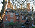 | 1870s | A brick house with stone dressings and a slate roof. It is in three storeys, and has an entrance front of four bays. Two of the bays project forward, and have gables with timbering and bargeboards. The garden front has three bays, a canted bay window with a balcony above, and half-dormers. Most of the windows are mullioned and transomed. [82] |
— | 38 Ullet Road 53°23′14″N2°56′47″W / 53.3872°N 2.9464°W |  | 1860s | A stuccoed house with a slate roof. It has four storeys, and a three-bay front. The windows and surrounds vary, some with architraves and pediments, and one containing seven round-headed lights. At the centre of the rear is a two-storey bow window. The entrance porch has a Doric-style colonnade with a balustraded balcony above. [83] |
— | 40 Ullet Road 53°23′15″N2°56′46″W / 53.3874°N 2.9462°W |  | 1860s | A stuccoed house with a slate roof. It has three storeys, and a five-bay front, the central bay being recessed. The windows are sashes with architraves. At the top of the house is a frieze and a cornice. In the first bay is a bay window. In the third bay is a five-bay blind arcade with archivolts and keystones, above which is a Venetian window with busts in roundels, and a pediment. [84] |
— | 42 Ullet Road 53°23′15″N2°56′45″W / 53.3876°N 2.9459°W |  | 1860s | A stuccoed house with a slate roof. It has three storeys, and a five-bay front. The windows are sashes and have architraves. In the middle bay is a five-bay blind arcade with archivolts and keystones. At the top of the house is a frieze and a cornice. The entrance is in the fourth bay, and has a rusticated surround. [85] |
| Restaurant | 44 Ullet Road 53°23′16″N2°56′44″W / 53.3877°N 2.9455°W |  | 1870s | Originally a house, later converted into a restaurant, it is built in common brick with dressings in red brick and stone, and has a slate roof. It has three storeys and a basement, and a front of three bays. Most of the windows are mullioned and transomed. Features include a tower with an octagonal turret surmounted by a conical roof, a Tudor arched entrance, gables with timbering and decorative bargeboards, and, at the rear, a balustraded terrace. [86] |
| Gates and gate piers | 44 Ullet Road 53°23′17″N2°56′45″W / 53.38796°N 2.94585°W | — | 1870s | The gates are wooden, between four stone gate piers. The piers have cornices decorated with Tudor flowers. They are castellated and have ogival caps with fish-scale pattern, crockets and fleurons. [87] |
| Sefton Court Mansions | 50 Ullet Road 53°23′18″N2°56′36″W / 53.3884°N 2.9433°W |  | 1860s | A stuccoed house with a hipped slate roof. It is mainly in three storeys with a basement, and has fronts of four and three bays. In the first bay is a canted bay window. The windows are sashes, those in the first floor with balustraded balconies. The porch has Doric columns, and above it is a pedimented window. The interior was remodelled in 1912, with decoration by the Bromsgrove Guild. [88] |
| Holt House | 54 Ullet Road 53°23′19″N2°56′24″W / 53.3887°N 2.9400°W |  | c. 1870 | The house was built for Robert Durning Holt, ship owner and first Lord Mayor of Liverpool. It is in red brick with sandstone dressings, and has a Welsh slate roof. The house has basically an L-shaped plan, and is in two storeys with a basement and attics. The entrance porch has Tuscan columns carrying an entablature and a frieze. The windows are sashes. Other features include canted bay windows, a Diocletian window and, at the top of the house, a parapet and a domed lantern. The attached garden walls are included in the listing. [89] |
| Wall and gate piers, Holt House | 54 Ullet Road 53°23′21″N2°56′25″W / 53.38911°N 2.94041°W |  | c. 1879 | The wall and gate piers are in sandstone. The wall extends along Ullet Road and around the garden of Holt House. There are two pairs of gate piers, all of which are panelled with pyramidal caps. [90] |
| Kelton | Woodlands Road 53°22′28″N2°55′34″W / 53.3744°N 2.9260°W |  | Early 19th century | A stuccoed house with a hipped slate roof. It has two storeys, and a three-bay front, the central bay projecting forward. At the top of the house is a frieze and a cornice. Other than one casement window, all the windows are sashes. The porch is in Ionic style, with paired columns. There have been later extensions. [91] |
