Grantwood Village, Missouri

Last updated

Grantwood Village, Missouri
Grant's Cabin.jpg
Grant's log cabin in 2015, located on Grant's Farm in Grantwood Village
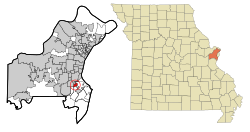
St. Louis County Missouri Incorporated and Unincorporated areas Grantwood Village Highlighted.svg
Location of Grantwood Village, Missouri
Coordinates: 38°33′03″N90°21′11″W / 38.55083°N 90.35306°W / 38.55083; -90.35306
Country United States
State Missouri
County St. Louis
Area
[1]
  Total0.83 sq mi (2.14 km2)
  Land0.82 sq mi (2.12 km2)
  Water0.01 sq mi (0.03 km2)
Elevation
[2]
492 ft (150 m)
Population
 (2020)
  Total941
  Density1,151.77/sq mi (444.86/km2)
Time zone UTC-6 (Central (CST))
  Summer (DST) UTC-5 (CDT)
FIPS code 29-28630 [3]
GNIS feature ID2396972 [2]
Website www.grantwoodvillage.us

Grantwood Village is a town in St. Louis County, Missouri, United States. The population was 863 at the 2010 census. [4]

Contents

Geography

According to the United States Census Bureau, the village has a total area of 0.83 square miles (2.15 km2), all land. [5]

Demographics

Historical population
CensusPop.Note
1940 86
1950 13354.7%
1960 676408.3%
1970 99447.0%
1980 1,0020.8%
1990 904−9.8%
2000 883−2.3%
2010 863−2.3%
2020 9419.0%
U.S. Decennial Census [6]

2010 census

As of the census [7] of 2010, there were 863 people, 340 households, and 262 families living in the village. The population density was 1,039.8 inhabitants per square mile (401.5/km2). There were 351 housing units at an average density of 422.9 per square mile (163.3/km2). The racial makeup of the village was 99.0% White, 0.6% African American, 0.2% Asian, and 0.2% from two or more races. Hispanic or Latino of any race were 0.8% of the population.

There were 340 households, of which 30.3% had children under the age of 18 living with them, 70.0% were married couples living together, 5.0% had a female householder with no husband present, 2.1% had a male householder with no wife present, and 22.9% were non-families. 19.4% of all households were made up of individuals, and 11.1% had someone living alone who was 65 years of age or older. The average household size was 2.54 and the average family size was 2.92.

The median age in the village was 50.5 years. 23.1% of residents were under the age of 18; 4.2% were between the ages of 18 and 24; 14% were from 25 to 44; 35.2% were from 45 to 64; and 23.4% were 65 years of age or older. The gender makeup of the village was 48.1% male and 51.9% female.

2000 census

As of the census [3] of 2000, there were 883 people, 347 households, and 284 families living in the town. The population density was 1,054.1 inhabitants per square mile (407.0/km2). There were 361 housing units at an average density of 431.0 per square mile (166.4/km2). The racial makeup of the town was 98.30% White, 0.23% African American, 0.45% Asian, 0.68% from other races, and 0.34% from two or more races. Hispanic or Latino of any race were 0.45% of the population.

There were 347 households, out of which 28.0% had children under the age of 18 living with them, 74.4% were married couples living together, 6.6% had a female householder with no husband present, and 17.9% were non-families. 17.3% of all households were made up of individuals, and 14.1% had someone living alone who was 65 years of age or older. The average household size was 2.54 and the average family size was 2.86.

In the town the population was spread out, with 23.0% under the age of 18, 3.3% from 18 to 24, 17.9% from 25 to 44, 26.8% from 45 to 64, and 29.0% who were 65 years of age or older. The median age was 50 years. For every 100 females, there were 91.5 males. For every 100 females age 18 and over, there were 89.4 males.

The median income for a household in the town was $91,754, and the median income for a family was $90,844. Males had a median income of $66,250 versus $35,417 for females. The per capita income for the town was $52,008. About 0.7% of families and 1.8% of the population were below the poverty line, including 2.0% of those under age 18 and 0.8% of those age 65 or over.

Attractions

Grantwood Village is home to two major attractions: the Ulysses S. Grant National Historic Site (White Haven) and Grant's Farm. Most of the village, including Grant's Farm, was once part of the larger plantation owned by Mrs. Grant's family. The farm itself was purchased by August Anheuser Busch, Sr., and is the ancestral home to family members of Anheuser-Busch.

Notable people

Related Research Articles

<span class="mw-page-title-main">Oakfield, Maine</span> Town in the state of Maine, United States

Oakfield is a town in Aroostook County, Maine, United States. The population was 661 at the 2020 census. The village of Oakfield, listed as a census-designated place, is in the northwestern corner of the town.

<span class="mw-page-title-main">Rives, Missouri</span> Village in Missouri, United States

Rives is a town in Dunklin County, Missouri, United States. The population was 63 at the 2010 census.

<span class="mw-page-title-main">Grand Falls Plaza, Missouri</span> Village in Missouri, United States

Grand Falls Plaza is a village in Newton County, Missouri, United States. The population was 114 at the 2010 census, at which time it was a town. It is part of the Joplin, Missouri Metropolitan Statistical Area.

<span class="mw-page-title-main">Ashburn, Missouri</span> Town in Missouri, United States

Ashburn is an town in Pike County, Missouri, United States. The population was 52 at the 2010 census.

<span class="mw-page-title-main">Mount Leonard, Missouri</span> Town in Missouri, United States

Mount Leonard is a town in Saline County, Missouri, United States. The population was 87 at the 2010 census.

<span class="mw-page-title-main">Gerster, Missouri</span> Town in Missouri, United States

Gerster is a town in St. Clair County, Missouri, United States. The population was 21 at the 2020 census.

<span class="mw-page-title-main">Huntleigh, Missouri</span> City in Missouri, United States

Huntleigh is a city in St. Louis County, Missouri, United States. The population was 334 at the 2010 census.

<span class="mw-page-title-main">Moundville, Missouri</span> Village in Missouri, United States

Moundville is a village in southwest Vernon County, Missouri, United States. The population was 124 at the 2010 census.

<span class="mw-page-title-main">Cedar Creek, Nebraska</span> Village in Nebraska, United States

Cedar Creek is a village in Cass County, Nebraska, United States. The population was 465 at the 2020 census.

<span class="mw-page-title-main">Boys Town, Nebraska</span> Village in Douglas County, Nebraska, United States

Boys Town is a village in Douglas County, Nebraska, United States. The population was 410 at the 2020 census. Boys Town is an enclave and a suburb of Omaha.

<span class="mw-page-title-main">Odell, Nebraska</span> Village in Nebraska, United States

Odell is a village in Gage County, Nebraska, United States. The population was 260 at the 2020 census.

<span class="mw-page-title-main">Holloway, Ohio</span> Village in Ohio, United States

Holloway is a village in Belmont County, Ohio, United States. The population was 330 at the 2020 census. It is part of the Wheeling metropolitan area. Holloway was laid out in 1883, and named after the local Holloway family.

<span class="mw-page-title-main">Martinsburg, Ohio</span> Village in Ohio, United States

Martinsburg is a village in Knox County, Ohio, United States. The population was 222 at the 2020 census.

<span class="mw-page-title-main">St. Louisville, Ohio</span> Village in Ohio, United States

St. Louisville is a village in Licking County, Ohio, United States, along the North Fork of the Licking River. The population was 352 at the 2020 census.

<span class="mw-page-title-main">Port Jefferson, Ohio</span> Village in Ohio, United States

Port Jefferson is a village in Salem Township, Shelby County, Ohio, United States. The population was 371 at the 2010 census.

<span class="mw-page-title-main">McDonald, Ohio</span> Village in Ohio, United States

McDonald is a village in southern Trumbull County, Ohio, United States, along the Mahoning River. The population was 3,172 at the 2020 census. It is a suburb of the Youngstown–Warren metropolitan area.

<span class="mw-page-title-main">Beech Bottom, West Virginia</span> Village in West Virginia, United States

Beech Bottom is a village in Brooke County, West Virginia, United States, situated along the Ohio River. The population was 523 at the 2010 census. It is part of the Weirton–Steubenville metropolitan area.

<span class="mw-page-title-main">Bellevue, Wisconsin</span> Village in Wisconsin, United States

Bellevue is a village in Brown County, Wisconsin. It was a town until incorporating as a village on February 14, 2003. The population was 14,570 at the time of the 2010 census. Bellevue is part of the Green Bay metropolitan area. Bellevue sits around 4.34 miles (6.99km) east from central Green Bay.

<span class="mw-page-title-main">Patch Grove, Wisconsin</span> Village in Wisconsin, United States

Patch Grove is a village in Grant County, Wisconsin, United States. The population was 198 at the 2010 census. The village is located within the Town of Patch Grove.

<span class="mw-page-title-main">Star Prairie, Wisconsin</span> Village in Wisconsin, United States

Star Prairie is a village in St. Croix County in the U.S. state of Wisconsin. The population was 561 at the 2010 census. The village is located along the Apple River on the boundary between the Town of Star Prairie and the Town of Stanton.

References

  1. "ArcGIS REST Services Directory". United States Census Bureau. Retrieved August 28, 2022.
  2. 1 2 U.S. Geological Survey Geographic Names Information System: Grantwood Village, Missouri
  3. 1 2 "U.S. Census website". United States Census Bureau . Retrieved January 31, 2008.
  4. "Race, Hispanic or Latino, Age, and Housing Occupancy: 2010 Census Redistricting Data (Public Law 94-171) Summary File (QT-PL), Grantwood Village village, Missouri". United States Census Bureau . Retrieved October 25, 2011.
  5. "US Gazetteer files 2010". United States Census Bureau. Archived from the original on January 25, 2012. Retrieved July 8, 2012.
  6. "Census of Population and Housing". Census.gov. Retrieved June 4, 2015.
  7. "U.S. Census website". United States Census Bureau . Retrieved July 8, 2012.