Groton, New York

Last updated

Groton, New York
USA New York location map.svg
Red pog.svg
Groton, New York
Location within the state of New York
Usa edcp location map.svg
Red pog.svg
Groton, New York
Groton, New York (the United States)
Coordinates: 42°35′22.7″N76°22′1.9″W / 42.589639°N 76.367194°W / 42.589639; -76.367194
Country United States
State New York
County Tompkins County
Incorporated1817
Area
  Total49.54 sq mi (128.31 km2)
  Land49.41 sq mi (127.96 km2)
  Water0.13 sq mi (0.35 km2)  0.10%
Elevation
1,690 ft (515 m)
Population
 (2020)
  Total5,746
  Density115.98/sq mi (44.78/km2)
Time zone UTC-5 (Eastern (EST))
  Summer (DST) UTC-4 (EDT)
ZIP Code
13073
Area code(s) 315, 607
FIPS code 36-30972
GNIS feature ID951849
Website townofgrotonny.org

Groton is a town in Tompkins County, New York, United States. The population was 5,950 at the 2010 census. The name is taken from Groton, Massachusetts. [1]

Contents

The Town of Groton contains a village, also called Groton. The town is in the northeast corner of the county and is northeast of Ithaca.

As well as a village, the Town of Groton also includes a former school, Groton High School, which was listed on the National Register of Historic Places in 1994.

History

Groton was in the former Central New York Military Tract.

The town was formed in 1817, before the formation of Tompkins County, from the Town of Locke (in Cayuga County) as the "Town of Division." Many of the early residents from New England elected to change the name to "Groton."

In 1888, the community of Groton separated from the town by incorporating as a village. Groton was also home to the original Corona Typewriter Company which later merged to form Smith Corona.

Geography

According to the United States Census Bureau, the town has a total area of 128.4 km2 (49.6 sq mi). 128.3 km2 (49.5 sq mi) of it is farmland and 0.1 km2 (0.04 sq mi) of it (0.10%) is water.

The north town line is the border of Cayuga County, and the east side town line is the border of Cortland County. The southern border is with the Town of Dryden and the western border with the Town of Lansing.

Groton is in the Finger Lakes region of central New York State.

North-south New York State Route 38 intersects New York State Route 222 at Groton village. New York State Route 34B is an east–west highway by the south town line.

Demographics

Historical population
CensusPop.Note
1820 2,742
1830 3,59731.2%
1840 3,6180.6%
1850 3,342−7.6%
1860 3,5345.7%
1870 3,512−0.6%
1880 3,450−1.8%
1890 3,5723.5%
1900 3,564−0.2%
1910 3,280−8.0%
1920 4,12225.7%
1930 3,789−8.1%
1940 3,8792.4%
1950 4,2469.5%
1960 4,4695.3%
1970 4,8819.2%
1980 5,2136.8%
1990 5,4835.2%
2000 5,7945.7%
2010 5,9502.7%
2020 5,746−3.4%
U.S. Decennial Census [2]

As of the census [3] of 2000, there were 5,794 people, 2,168 households, and 1,543 families residing in the town. The population density was 116.9 inhabitants per square mile (45.1/km2). There were 2,287 housing units at an average density of 46.2 units per square mile (17.8 units/km2). The racial makeup of the town was 97.38% White, 0.64% Black or African American, 0.09% Native American, 0.24% Asian, 0.26% from other races, and 1.40% from two or more races. Hispanic or Latino of any race were 0.79% of the population.

There were 2,168 households, out of which 35.8% had children under the age of 18 living with them, 55.9% were married couples living together, 10.6% had a female householder with no husband present, and 28.8% were non-families. 23.1% of all households were made up of individuals, and 9.7% had someone living alone who was 65 years of age or older. The average household size was 2.62 and the average family size was 3.09.

In the town, the population was spread out, with 28.1% under the age of 18, 6.4% from 18 to 24, 28.7% from 25 to 44, 23.9% from 45 to 64, and 12.8% who were 65 years of age or older. The median age was 37 years. For every 100 females, there were 95.9 males. For every 100 females age 18 and over, there were 91.1 males.

The median income for a household in the town was $42,407, and the median income for a family was $50,057. Males had a median income of $31,890 versus $23,642 for females. The per capita income for the town was $18,075. About 4.8% of families and 6.0% of the population were below the poverty line, including 7.3% of those under age 18 and 4.8% of those age 65 or over.

2020 Census

As of the census of 2020, [4] there were 5,746 people, 2,372 households, and an unknown number of families residing in the town. The population density was 115.98 people per square mile (44.78 people/km2). There were 2,561 housing units at an average density of 51.69 per square mile (19.96/km2). The racial makeup of the town was 88.06% White, 1.02% Black or African American, 0.29% Native American, 0.71% Asian, 1.53% from other races, and 8.37% from two or more races. Hispanic or Latino of any race were 3.72% of the population. An estimated 18.0% were of German ancestry, 13.3% English, 12.3% Irish, and 7.8% Italian.

There were 2,372 households, out of which 36.6% had children under the age of 18 living with them, 56.5% were married couples living together, 18.8% had a female householder with no spouse/partner present, and 15.9% had a male householder with no spouse/ partner present. The average household size was 2.41 and the average family size was 2.86. [5]

In the town, the population was spread out, with 22.7% under the age of 18, 6.4% from 18 to 24, 34.8% from 15 to 44, and 14.2% who were 65 years of age or older. The median age was 39.7 years. [6]

The median income for a household in the town was $59,625, and the median income for a family was $77,738. The per capita income for the town was $29,571. About 5.5% of the population is below the poverty line, including 4.3% of those under age 18 and 6.8% of those age 65 or over.

Communities and locations in the Town of Groton

Notable people

Related Research Articles

<span class="mw-page-title-main">Dayton, New York</span> Town in New York, United States

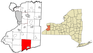
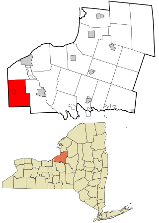
Dayton is a town in Cattaraugus County, New York, United States. The population was 1,689 at the 2020 census. The town is on the western border of Cattaraugus County.

<span class="mw-page-title-main">Locke, New York</span> Town in New York, United States

Locke is a town in Cayuga County, New York, United States. The population was 1,877 at the 2020 census. The town was named after John Locke, an English philosopher, and is the birthplace of Millard Fillmore, 13th President of the United States.

<span class="mw-page-title-main">Summerhill, New York</span> Town in New York, United States

Summerhill is a town in Cayuga County, New York, United States. The population was 1,217 at the 2010 census. The town name is that of a location in Ireland. Summerhill is in the southeastern corner of the county and is northeast of Ithaca.

<span class="mw-page-title-main">Pitcher, New York</span> Town in New York, United States

Pitcher is a town in Chenango County, New York, United States. The population was 803 at the 2010 census. The town is named after Nathaniel Pitcher, the eighth governor of New York. The town is on the western border of Chenango County, west of the city of Norwich.

<span class="mw-page-title-main">Saranac, New York</span> Town in New York, United States

Saranac is a town in Clinton County, New York, United States. The town is on the western border of the county, west of Plattsburgh, and is within the Adirondack Park. The population was 3,852 at the 2020 census, down from 4,007 at the 2010 census. The town is named for the Saranac River that flows through the town.

<span class="mw-page-title-main">Cortlandville, New York</span> Town in New York, United States

Cortlandville is a town in Cortland County, New York, United States. The population was 8,509 at the 2010 census.

<span class="mw-page-title-main">Concord, New York</span> Town in New York, United States

Concord is a town in Erie County, New York, United States. The population was 8,494 at the 2010 census. The town is believed to be named after Concord, Massachusetts, by early settlers from New England.

<span class="mw-page-title-main">Salisbury, Herkimer County, New York</span> Town in New York, United States

Salisbury is a town in Herkimer County, New York, United States. The population was 1,958 at the 2010 census. The town is on the eastern edge of the county, north of the city of Little Falls. The northern part of the town is in the Adirondack Park.

<span class="mw-page-title-main">Winfield (town), New York</span> Town in New York, United States

Winfield is a town in Herkimer County, New York, United States. The population was 2,086 at the 2010 census. The town is named after General Winfield Scott and is in the southwestern corner of the county, south of Utica.

<span class="mw-page-title-main">Charleston, New York</span> Town in Montgomery County, NY

Charleston is a town in Montgomery County, New York, United States. The population was 1,373 at the 2010 census. The town was named for Charles Van Epps, an early settler.

<span class="mw-page-title-main">Marshall, New York</span> Town in New York, United States

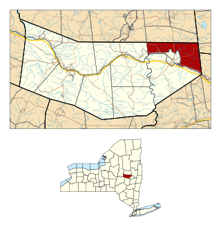
Marshall is a town in Oneida County, New York, United States. The population was 1,966 at the 2020 census.

South Bristol is a town in Ontario County, New York, United States. The population was 1,651 at the 2020 census. The name is derived from its separation from the Town of Bristol.

<span class="mw-page-title-main">Palermo, New York</span> Town in New York, United States

Palermo is a town in Oswego County in the U.S. state of New York. The population was 3,664 at the 2010 census. The town is named after Palermo in Sicily.

<span class="mw-page-title-main">Fowler, New York</span> Town in New York, United States

Fowler is a town in St. Lawrence County, New York, United States. The population was 2,202 at the 2010 census.

<span class="mw-page-title-main">Moravia, New York</span> Town in New York, United States

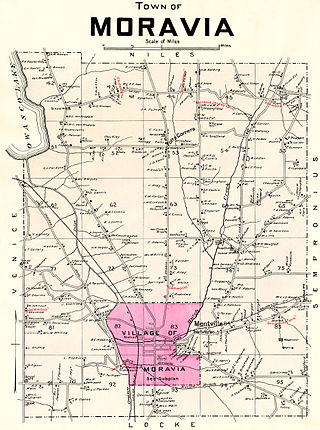
Moravia is a town in Cayuga County, New York. The population was 3,626 at the time of the 2010 census.

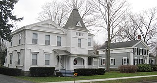
Hamilton is a town in Madison County, New York, United States. The population was 6,379 at the 2020 census. The town is named after American Founding Father Alexander Hamilton, and is a college town, with Colgate University dominating the town's employment, culture and population.

<span class="mw-page-title-main">Amsterdam (town), New York</span> Town in New York, United States

Amsterdam is a town in Montgomery County, New York, United States. The population was 5,566 at the 2010 census. The town is named after Amsterdam, the capital of the Netherlands.

<span class="mw-page-title-main">Hannibal, New York</span> Town in New York, United States

Hannibal is a town in Oswego County, New York, United States. The population was 4,854 at the 2010 census. The name is derived from the hero of ancient Carthage, Hannibal.

<span class="mw-page-title-main">Dryden, New York</span> Town in New York, United States

Dryden is a town in Tompkins County, New York, United States. The population was 14,435 at the 2010 census. The town administers an area that includes two villages, one also named Dryden and one named Freeville, as well as a number of hamlets. The town is on the county's eastern border, east of Ithaca, in the Finger Lakes region.

<span class="mw-page-title-main">Ithaca (town), New York</span> Town in New York, United States

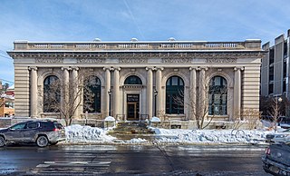
Ithaca is a town in Tompkins County, New York, United States. The town's population was 22,283 at the 2020 census. The town is in the central part of the county, in the Finger Lakes–Southern Tier region of New York, and is part of the Ithaca Metropolitan Statistical Area. The Town of Ithaca is a horseshoe-shaped portion of the metropolitan area of Ithaca, New York, surrounding the City of Ithaca and being the city's only border. Ithaca College is located in the South Hill section of the town.

References

  1. Gannett, Henry (1905). The Origin of Certain Place Names in the United States. Govt. Print. Off. pp.  145.
  2. "Census of Population and Housing". Census.gov. Retrieved June 4, 2015.
  3. "U.S. Census website". United States Census Bureau . Retrieved January 31, 2008.
  4. "2020 U.S. Census website". United States Census Bureau . Retrieved July 20, 2022.
  5. "2020 American Community Survey: Selected Social Characteristics in the United States". United States Census Bureau . Retrieved July 20, 2022.
  6. "2020 American Community Survey: Age and Sex". United States Census Bureau . Retrieved July 20, 2022.