
Kuwohi is a mountain in the Great Smoky Mountains of Tennessee and North Carolina in the Southeastern United States.

Arnold Henry Guyot was a Swiss-American geologist and geographer.

South Twin Mountain is a mountain located in Grafton County, New Hampshire, United States. The mountain is part of the Twin Range of the White Mountains. South Twin forms the high point of a north–south ridge, with North Twin Mountain lying approximately one mile to the north and Mount Guyot two miles (3.2 km) to the southeast. Galehead Mountain, a lower spur of South Twin, is to the west.

Guyot Glacier is a 34-mile (55 km) long and 8-mile (13 km) wide glacier located in the east end of the Robinson Mountains in the U.S. state of Alaska. It begins 5.6 mi (9.0 km) north of Yaga Peak and heads east-southeast to Icy Bay, south of the Guyot Hills and 73 miles (117 km) northwest of Yakutat. It borders Yahtse Glacier on the northeast. The glacier was named by the New York Times expedition of 1886 for Arnold Henry Guyot.

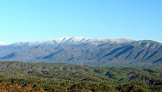
The Black Mountains are a mountain range in western North Carolina, in the southeastern United States. They are part of the Blue Ridge Province of the Southern Appalachian Mountains. The Black Mountains are the highest mountains in the Eastern United States. The range takes its name from the dark appearance of the red spruce and Fraser fir trees that form a spruce-fir forest on the upper slopes which contrasts with the brown or lighter green appearance of the deciduous trees at lower elevations. The Eastern Continental Divide, which runs along the eastern Blue Ridge crest, intersects the southern tip of the Black Mountain range.
Mount Bond is a mountain located in Grafton County, New Hampshire, United States. The mountain is named after Professor George P. Bond (1825–1865) of Harvard University, and is the southernmost extension of the Twin Range of the White Mountains. Mount Bond is flanked to the north by Mount Guyot.
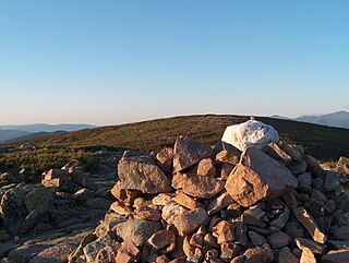
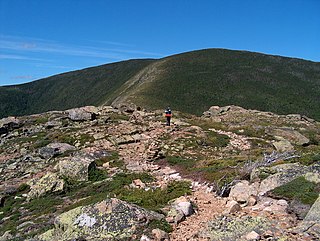
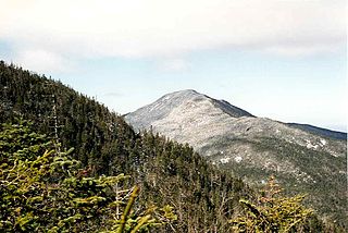
Mount Guyot is a mountain located in Grafton County, New Hampshire. The mountain is named after Professor Arnold H. Guyot (1807–1884) of Princeton University, and is part of the Twin Range of the White Mountains. Mount Guyot is flanked to the northwest by South Twin Mountain, to the northeast by Mount Zealand, and to the south by Mount Bond. Guyot is on the northern boundary of the Pemigewasset Wilderness. The immediate area around the summit consists of high-altitude spruce-fir forest or krummholz.
Thunderhead Mountain is a 5,527-foot (1,685 m) mountain in the west-central part of the Great Smoky Mountains, located in the southeastern United States. Rising along the border between Tennessee and North Carolina, the mountain dominates the western Smokies. The Appalachian Trail crosses its summit, making it a popular hiking destination. Rocky Top, a knob on the western part of the mountain's summit ridge, shares its name with a popular Tennessee state song.

Silers Bald is a mountain in the western Great Smoky Mountains, located in the southeastern United States with the Great Smoky Mountains National Park. Its proximity to Kuwohi and its location along the Appalachian Trail make it a popular hiking destination.

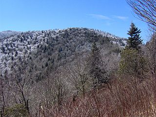
Mount Kephart is a mountain in the central Great Smoky Mountains, located in the Southeastern United States. The Appalachian Trail crosses the mountain's south slope, making it a destination for thru-hikers. The Jumpoff, a 1,000-foot (300 m) cliff on the northeast side of the mountain, has views of the central and eastern Smokies. A stand of Southern Appalachian spruce-fir forest coats the mountain's upper elevations.
Old Black is a mountain in the Great Smoky Mountains, located in the Southeastern United States. While often overshadowed by Mount Guyot, its higher neighbor to the south, Old Black is the 5th-highest mountain in Tennessee and the 7th-highest in the Great Smoky Mountains National Park. The Appalachian Trail crosses its western slope, connecting the Cosby-area trail system with the heart of the eastern Smokies.

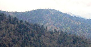
Mount Guyot is a mountain in the Great Smoky Mountains, located in the southeastern United States. At 6,621 feet (2,018 m) in elevation, Guyot is the fourth-highest summit in the Eastern U.S., and the second-highest in the Great Smoky Mountains National Park. While the mountain is remote, the Appalachian Trail crosses its south slope, passing to within 1,000 feet (300 m) of the summit.
Mount Sequoyah is a mountain in the Great Smoky Mountains, located in the Southeastern United States. It has an elevation of 6,003 feet above sea level. While the Appalachian Trail crosses its summit, Sequoyah is an 11.5-mile (18.5 km) hike from the nearest parking lot, making it one of the most remote places in the Great Smoky Mountains National Park.

Mount Collins is a mountain in the Great Smoky Mountains, located in the Southeastern United States. It has an elevation of 6,188 feet (1,886 m) above sea level. Located along the Appalachian Trail between Kuwohi and Newfound Gap, the mountain is a popular destination for thru-hikers. A backcountry shelter and a major trail junction are located along the mountain's northeastern slope. The mountain's summit is covered by a southern Appalachian spruce–fir forest.

Mount Chapman is a mountain in the Great Smoky Mountains, located in the Southeastern United States. It has an elevation of 6,427 feet above sea level. While the mountain is located deep within the Smokies, the Appalachian Trail crosses its eastern slope, coming to within 200 feet (61 m) of the summit. Mount Chapman is among the 10 highest mountains in the Appalachian range, if subpeaks are not included.
Seward Mountain is a mountain in the Seward Range of the Adirondacks in the U.S. state of New York. It is the 24th-highest of the Adirondack High Peaks, with an elevation of 4,361 feet (1,329 m). The mountain is located in the town of Harrietstown in Franklin County. It is named for New York governor William Seward.

Seymour Mountain is a mountain located in Franklin County, New York, named after Horatio Seymour (1810–1886), Governor of New York. The mountain is part of the Seward Mountains of the Adirondacks. Seymour Mountain faces Seward Mountain to the west across Ouluska Pass.
Bonticou Crag is a mountain in the Shawangunk Mountains,of New York south of High Falls. Formally Known as Bunticoo Point and Bontecou Crag. Guyot Hill is located west-southwest of Bonticou Crag. A 2.3 mile loop hike called Bonticou Crag Trail is available for hikers to explore the area which begins at the Bonticou Crag trailhead.

Mount Guyot is a high mountain summit in the Front Range of the Rocky Mountains of North America. The 13,376-foot (4,077 m) thirteener is located 6.3 miles (10.2 km) east-southeast of the Town of Breckenridge, Colorado, United States, on the Continental Divide separating Pike National Forest and Park County from Arapaho National Forest and Summit County. The mountain was named in honor of Arnold Henry Guyot, a Swiss-American geologist.

