
Gadag is a district in the state of Karnataka, India. It was formed in 1997, when it was split from Dharwad district. As of 2011, it had a population of 1064570. The overall population increased by 13.14 percent from 1991 to 2001. Gadag district borders Bagalkot district on the north, Koppal district on the east, Vijayanagara district on the southeast, Haveri district on the southwest, Dharwad district on the west and Belgaum District on the northwest. It is famous for the many monuments from the Western Chalukya Empire. It has seven talukas: Gadag, Gajendragad, Ron, Shirhatti, Nargund, Lakshmeshwar and Mundargi.

Lakkundi, also referred to as Lokkugundi, was a major city prior to the 14th-century, and is now a village in Gadag District of Karnataka, India. By 10th-century, it was already a major economic and commerce center with mint operations for South India, one mentioned in Kannada and Sanskrit inscriptions and texts. By 12th-century, a galaxy of Hindu and Jain temples had been consecrated here, along with public infrastructure such as step wells and water reservoirs. Among the major temples are the Brahma Jinalaya (oldest), Mallikarjuna, Lakshminarayana, Manikeshwara, Naganatha, Kumbheshvara, Nanneshwara, Someshwara, Narayana, Nilakanteshwara, Kasivisesvara, Virabhadhara, Virupaksha, and others. As its importance and wealth grew, Lakkundi became one of the capitals of the Hoysalas.

Sirsi is a moderate city in Uttara Kannada district, Karnataka, India. Sirsi was also known as Kalyanapattana during the Sonda Dynasty.

North Karnataka, is a geographical region in Deccan plateau from 300 to 730 metres elevation that constitutes the region of the Karnataka state in India and the region consists of 13 districts. It is drained by the Krishna River and its tributaries the Bhima, Ghataprabha, Malaprabha, and Tungabhadra. North Karnataka lies within the Deccan thorn scrub forests ecoregion, which extends north into eastern Maharashtra. Most parts of the region has black fertile soil ideal for agriculture.

Annigeri is a taluk of Dharwad district in the state of Karnataka, India, located 20 km west of Gadag en route to Hubli and 35 km from Hubli.
Mudgal is a panchayat town in Lingsugur taluk, Raichur district in the Indian state of Karnataka. Mudgal is about 10 miles south-west of Lingsugur.
Ron is a taluka headquarters in Gadag district, Karnataka in India. Of historical importance, the town was termed Dronapur in ancient times. The temples are believed to be constructed by the ancient architect and warrior-priest Dronacharya.
Sreekandapuram is a municipality in Kannur district, in the Indian state of Kerala.
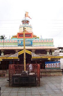
Banashankari Devi Temple is a Hindu shrine located at Cholachagudda near Badami, in Bagalkot district, Karnataka, India. The temple is popularly called °Shakambhari°' 'Banashankari or Vanashankari' 'since it is located in the Tilakaaranya forest. The temple deity is also called the Shakambhari, an incarnation of the goddess Parvati.

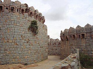
Sudi, is a panchayat town in the Gadag District of Karnataka, India. It is about 30 km from Badami, 12 km from Gajendragad and 3 km from Itagi Bhimambika temple. In the past it was an important town of the Kalyani Chalukyas during 1000 AD. It is notable for rare stone carved monuments like Twin towered temple, Mallikarjuna temple and nagakunda , and few other structural temples. For long time these structures were abandoned, but recently they caught the eye of the Indian Archaeological Department.

Wadakkancherry is a major town in Thrissur, Kerala. Up until 1860, this area was part of Chelakkara Taluk. Now, it is the headquarters of Talappilly Taluk.
Shirahatti is a panchayat town in Gadag district in the Indian state of Karnataka.

Belavanaki is a village in southern state of Karnataka, India. It is located in Ron Taluka of Gadag district in Karnataka. It belongs to Belagavi Division.
Hanamsagar, also spelled as Hanumasagara is a village in the Kushtagi taluk of Koppal district in Karnataka state, India.
There are places of worship considered important in the Kannur district. Kannur District is one of the 14 districts in the state of Kerala, India. The town of Kannur is the district headquarters, and gives the district its name.

Polali Rajarajeshwari Temple is a temple located in Polali, Dakshina Kannada district in Karnataka. The primary deity of the temple is Shri Rajarajeshwari. The temple was constructed in the 8th century AD by King Suratha and has been developed by many dynasties which ruled over the region. The idol of Sri Rajarajeshwari, another name/form of the divine Goddess Sri Lalita Tripurasundari, is completely moulded from clay with special medicinal properties. The temple portrays Hindu architecture with roofs adorned with wooden carvings of gods and copper plates. Daily and special poojas are conducted in the temple under the auspices of the head priest madhava bhat. Annual festivals are held in the temple with much fanfare. Polali Chendu festival is an important festive event where football is played to represent the fight of good over evil. The Chendu festival is followed by the annual festival in March, which lasts for a month and is attended by people from all over the world.

Kadamba architecture was a style of temple architecture founded by Mayurasharma in the 4th century AD in Karnataka, India. Kadambas created new style of architecture which was the basis of the Hoysalas style of architecture, developed original school of sculpture, was the forerunner of series of South Indian sculptors. Many temples at Aihole, Badami and Hampi are built in Kadamba style.
Kanaginahal is a village in the Gadag district of Karnataka State in India. The first co-operative society of India was registered in 1905 at Kanaginahal village.
Venkatapura is a village in the Gadag district of Karnataka State in India, about 15 kilometres (9.3 mi) from Gadag.


