
Ben Hill County is a county located in the U.S. state of Georgia. As of the 2020 census, the population was 17,194. The county seat is Fitzgerald. The county was organized in 1906. It is named after Benjamin Harvey Hill, a former Confederate and United States Senator.

Herkimer is a town in Herkimer County, New York, United States, southeast of Utica. It is named after Nicholas Herkimer. The population was 9,566 at the 2020 census, down from 10,175 in 2010.

Capitol Hill is a neighborhood in Washington, D.C., located in both Northeast D.C. and Southeast D.C.. Bounded by 14th Street SE & NE, F Street NE, Southeast Boulevard SE, South Capitol Street SE. Dominated by the United States Capitol, which sits on the highest point of Capitol Hill, it is one of the oldest historic districts in Washington. Home to around 35,000 people in just under 2 square miles (5 km2), Capitol Hill is also one of the most densely populated neighborhoods in Washington, D.C.. The name "Capitol Hill" is frequently used as a metonym for the U.S. Congress.

Walter Georg Alfred Hasenclever was a German Jewish Expressionist poet and playwright. His works were banned when the Nazis came to power and he went into exile in France. There he was imprisoned as a "foreign enemy". He died in Les Milles near Aix-en-Provence.

Procarbazine is a chemotherapy medication used for the treatment of Hodgkin's lymphoma and brain cancers. For Hodgkin's it is often used together with chlormethine, vincristine, and prednisone while for brain cancers such as glioblastoma multiforme it is used with lomustine and vincristine. It is typically taken by mouth.

Black Hills National Forest is located in southwestern South Dakota and northeastern Wyoming, United States. The forest has an area of over 1.25 million acres (5,066 km2) and is managed by the Forest Service. Forest headquarters are located in Custer, South Dakota. There are local ranger district offices in Custer, Rapid City, and Spearfish in South Dakota, and in Sundance, Wyoming.
Long Pond Ironworks State Park is located in the community of Hewitt, in West Milford, New Jersey, United States. The park is known for its old stone walls, furnaces and other remnants of a once industrious ironworking community that now sits next to the swiftly flowing Wanaque River. The park is operated and maintained by the New Jersey Division of Parks and Forestry and has an area of 145 acres (0.59 km2).
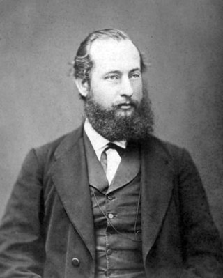
Wilhelm Hasenclever was a German politician. He was originally a tanner by trade but later became a journalist and author. However, he is most known for his political work in the predecessors of the Social Democratic Party of Germany (SPD).

The Black Hills is an isolated mountain range rising from the Great Plains of North America in western South Dakota and extending into Wyoming, United States. Black Elk Peak, which rises to 7,242 feet (2,207 m), is the range's highest summit. The name of the range in Lakota is Pahá Sápa. It encompasses the Black Hills National Forest. It formed as a result of an upwarping of ancient rock, after which the removal of the higher portions of the mountain mass by stream erosion produced the present-day topography. The hills are so called because of their dark appearance from a distance, as they are covered in evergreen trees.
Sandyfield was a settlement of about 30 houses in the Town of Ramapo in Rockland County, New York, United States, that was submerged in 1928 when swampy Beaver Pond was dammed to create Lake Welch in Harriman State Park.
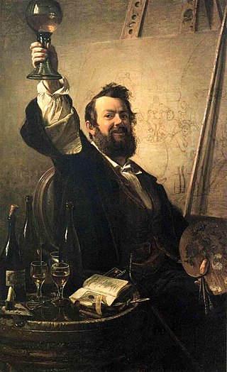
Johann Peter Hasenclever was a German genre painter, associated with the Düsseldorfer Malerschule.
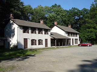
Tranquility Ridge Park is a 2,062 acre Watershed Protection Area that spans the border of Ringwood and West Milford, New Jersey, United States, and is directly south of the New Jersey-New York State Line. Tranquility Ridge Park is directly adjacent to Sterling Forest State Park in NY, and Long Pond Ironworks State Park in NJ. The area was once part of Long Pond Ironworks, which was developed as an ironworks "plantation" by Peter Hasenclever in 1766, and produced iron for American forces during the American Revolutionary War, the War of 1812, and the American Civil War.

Rum Hill is a mountain located in Central New York Region of New York northwest of the Hamlet of Pierstown. Red House Hill is located southeast, Metcalf Hill is located south, Allen Lake and Mohegan Hill are located north-northwest and Otsego Lake is located east of Rum Hill.
Fitch Hill is a mountain located in Central New York Region of New York by Pierstown. Fitch Hill is named after the Fitch family who were early settlers in the area.
Kilkenny Hill is a mountain in the Central New York region of New York, United States. It is located northwest of Unadilla, New York. Kilkenny Hill is part of the Northern Allegheny Plateau Ecoregion.
Red Hill is a mountain located in the Catskill Mountains of New York east-south of Frost Valley. Woodhull Mountain is located northeast of Red Hill.
Gallis Hill is a 794-foot-tall (242 m) mountain in the Catskill Mountains region of New York. It is located northwest of Kingston in Ulster County. Jockey Hill is located north-northeast, and Morgan Hill is located west of Gallis Hill. In 1927, the Conservation Department built a steel fire lookout tower on the mountain. In 1950, the tower was closed and disassembled then moved to Overlook Mountain, where it still remains today.
Leonard Hill is a 2,592-foot-tall (790 m) mountain in Schoharie County, New York. It is located east-southeast of North Blenheim. Safford Hill is located northwest and Hubbard Hill is located southeast of Leonard Hill. In 1948, the Conservation Commission built an 80-foot-tall (24 m) steel fire lookout tower on the mountain. The tower ceased fire watching operations at the end of the 1988 season and was officially closed in early 1989. The tower remains on the summit, but is closed to the public. A local group is planning to restore the tower and reopen it to the public.

Sophie Hasenclever was a German poet and translator.

