Height gauge

Last updated
The left height gauge has the vernier scale, while the right one is an electronic height gauge with a digital readout. GaugeHeightVernier-Electronic.jpg
The left height gauge has the vernier scale, while the right one is an electronic height gauge with a digital readout.

A height gauge is a measuring device used for determining the height of objects, and for marking of items to be worked on.

These measuring tools are used in metalworking or metrology to either set or measure vertical distances; the pointer is sharpened to allow it to act as a scriber and assist in marking out work pieces.

Devices similar in concept, with lower resolutions, are used in health care settings (health clinics, surgeries) to find the height of people, in which context they are called stadiometers .

Height gauges may also be used to measure the height of an object by using the underside of the scriber as the datum. The datum may be permanently fixed or the height gauge may have provision to adjust the scale, this is done by sliding the scale vertically along the body of the height gauge by turning a fine feed screw at the top of the gauge; then with the scriber set to the same level as the base, the scale can be matched to it. This adjustment allows different scribers or probes to be used, as well as adjusting for any errors in a damaged or resharpened probe.

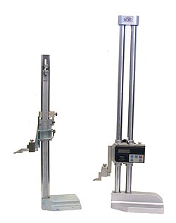
In the toolroom, the distinction between a height gauge and a surface gauge is that a height gauge has a measuring head (whether vernier, fine rack and pinion with dial, or linear encoder with digital display), whereas a surface gauge has only a scriber point. Both are typically used on a surface plate and have a heavy base with an accurately flat, smooth underside.

Related Research Articles

<span class="mw-page-title-main">Geodesy</span> Science of measuring the shape, orientation, and gravity of the Earth and other astronomical bodies

Geodesy is the science of measuring and representing the geometry, gravity, and spatial orientation of the Earth in temporally varying 3D. It is called planetary geodesy when studying other astronomical bodies, such as planets or circumplanetary systems.

<span class="mw-page-title-main">Micrometer (device)</span> Tool for the precise measurement of a components length, width, and/or depth

A micrometer, sometimes known as a micrometer screw gauge, is a device incorporating a calibrated screw widely used for accurate measurement of components in mechanical engineering and machining as well as most mechanical trades, along with other metrological instruments such as dial, vernier, and digital calipers. Micrometers are usually, but not always, in the form of calipers. The spindle is a very accurately machined screw and the object to be measured is placed between the spindle and the anvil. The spindle is moved by turning the ratchet knob or thimble until the object to be measured is lightly touched by both the spindle and the anvil.

<span class="mw-page-title-main">Submersible</span> Small watercraft able to navigate under water

A submersible is an underwater craft which needs to be transported and supported by a surface vessel or platform. This distinguishes submersibles from submarines, which are self-supporting and capable of independent operation.

<span class="mw-page-title-main">Combination square</span> Measuring and marking tool

A combination square is a multi-purpose measuring and marking tool used in metalworking, woodworking, and stonemasonry. It is composed of a rule and one or more interchangeable heads that can be attached to the rule. Other names for the tool include adjustable square, combo square, and sliding square.

<span class="mw-page-title-main">Inclinometer</span> Instrument used to measure the inclination of a surface relative to local gravity

An inclinometer or clinometer is an instrument used for measuring angles of slope, elevation, or depression of an object with respect to gravity's direction. It is also known as a tilt indicator, tilt sensor, tilt meter, slope alert, slope gauge, gradient meter, gradiometer, level gauge, level meter, declinometer, and pitch & roll indicator. Clinometers measure both inclines and declines using three different units of measure: degrees, percentage points, and topos. The astrolabe is an example of an inclinometer that was used for celestial navigation and location of astronomical objects from ancient times to the Renaissance.

<span class="mw-page-title-main">Levelling</span> Surveying technique

Levelling or leveling is a branch of surveying, the object of which is to establish or verify or measure the height of specified points relative to a datum. It is widely used in geodesy and cartography to measure vertical position with respect to a vertical datum, and in construction to measure height differences of construction artifacts.

<span class="mw-page-title-main">Hypsometer</span>

A hypsometer is an instrument for measuring height or elevation. Two different principles may be used: trigonometry and atmospheric pressure.

<span class="mw-page-title-main">Calipers</span> Tool used to measure dimensions of an object

Caliper(s) or calliper(s) are an instrument used to measure the dimensions of an object, generally by placing two movable points of the instrument across the object or span to be measured.

<span class="mw-page-title-main">Scriber</span> Hand tool for making marks on workpieces

A scriber is a hand tool used in metal work to mark lines on workpieces, prior to machining. The process of using a scriber is called scribing and is just part of the process of marking out. It is used instead of pencils or ink lines, because the latter are hard to see, easily erased, and imprecise due to their wide mark; scribe lines are thin and semi-permanent. On non-coated workpieces marking blue is commonly used to increase the contrast of the mark lines.

<span class="mw-page-title-main">Indicator (distance amplifying instrument)</span> Distance amplifying instrument

In various contexts of science, technology, and manufacturing, an indicator is any of various instruments used to accurately measure small distances and angles, and amplify them to make them more obvious. The name comes from the concept of indicating to the user that which their naked eye cannot discern; such as the presence, or exact quantity, of some small distance.

Marking out or layout means the process of transferring a design or pattern to a workpiece, as the first step in the manufacturing process. It is performed in many industries or hobbies although in the repetition industries the machine's initial setup is designed to remove the need to mark out every individual piece.

<span class="mw-page-title-main">Coordinate-measuring machine</span> Device for measuring the geometry of objects

A coordinate measuring machine (CMM) is a device that measures the geometry of physical objects by sensing discrete points on the surface of the object with a probe. Various types of probes are used in CMMs, the most common being mechanical and laser sensors, though optical and white light sensor do exist. Depending on the machine, the probe position may be manually controlled by an operator or it may be computer controlled. CMMs typically specify a probe's position in terms of its displacement from a reference position in a three-dimensional Cartesian coordinate system. In addition to moving the probe along the X, Y, and Z axes, many machines also allow the probe angle to be controlled to allow measurement of surfaces that would otherwise be unreachable.

<span class="mw-page-title-main">Level (optical instrument)</span> Optical instrument to verify horizontal points

A level is an optical instrument used to establish or verify points in the same horizontal plane in a process known as levelling. It is used in conjunction with a levelling staff to establish the relative height or levels of objects or marks. It is widely used in surveying and construction to measure height differences and to transfer, measure, and set heights of known objects or marks.

<span class="mw-page-title-main">Australian Height Datum</span> Vertical datum of Australia

The Australian Height Datum was introduced in 1971 as the official vertical datum for Australia, and thereby serves as the benchmark to which all height measurements are referred. The Australian Height Datum is an amalgamation of decades of spirit levelling work conducted by numerous state and territory authorities across the country, and was corrected to align with the mean sea level observations of thirty tide gauges positioned around the entire coastline. While it remains the published vertical datum for all surveying and engineering operations performed throughout Australia, newer technologies have uncovered numerous deficiencies, offsets and distortions within the Australian Height Datum, leading to discussions about defining a new Australian vertical datum.

<span class="mw-page-title-main">National Geodetic Vertical Datum of 1929</span> Vertical datum in the United States

The National Geodetic Vertical Datum of 1929 is the official name since 1973 of the vertical datum established for vertical control surveying in the United States of America by the General Adjustment of 1929. Originally known as Sea Level Datum of 1929, NGVD 29 was determined and published by the National Geodetic Survey and used to measure the elevation of a point above and depression below mean sea level (MSL).

A level staff, also called levelling rod, is a graduated wooden or aluminium rod, used with a levelling instrument to determine the difference in height between points or heights of points above a vertical datum. When used for stadiametric rangefinding, the level staff is called a stadia rod.

<span class="mw-page-title-main">Quadrant (instrument)</span> Navigation instrument

A quadrant is an instrument used to measure angles up to 90°. Different versions of this instrument could be used to calculate various readings, such as longitude, latitude, and time of day. Its earliest recorded usage was in ancient India in Rigvedic times by Rishi Atri to observe a solar eclipse. It was then proposed by Ptolemy as a better kind of astrolabe. Several different variations of the instrument were later produced by medieval Muslim astronomers. Mural quadrants were important astronomical instruments in 18th-century European observatories, establishing a use for positional astronomy.

<span class="mw-page-title-main">Vertical datum</span> Reference surface for vertical positions

In geodesy, surveying, hydrography and navigation, vertical datum or altimetric datum, is a reference coordinate surface used for vertical positions, such as the elevations of Earth-bound features and altitudes of satellite orbits and in aviation. In planetary science, vertical datums are also known as zero-elevation surface or zero-level reference.

This is a glossary of levelling terms. Levelling is a surveying method used to find relative height, one use of which is to ensure ground is level during construction, for example, when excavating to prepare for laying a foundation for a house.

Vertical position or vertical location is a position along a vertical direction above or below a given vertical datum . Vertical distance or vertical separation is the distance between two vertical positions. Many vertical coordinates exist for expressing vertical position: depth, height, altitude, elevation, etc. Points lying on an equigeopotential surface are said to be on the same vertical level, as in a water level.

References