Highway 90 is the longest Israeli road, at about 480 kilometres (300 mi), and stretches from Metula and the northern border with Lebanon, along the western side of the Sea of Galilee, through the Jordan Valley, along the Dead Sea's western bank, through the Arava Valley, and until Eilat and the southern border with Egypt on the Red Sea. The central section of the road traverses the Israeli-occupied West Bank. While it passes near the city of Jericho, it runs through Area C and does not enter areas controlled by the Palestinian Authority.

Highway 1 is the main highway in Israel, connecting Tel Aviv and Jerusalem, and continuing eastwards to the Jordan Valley in the West Bank.
Highway 50, officially called Begin Boulevard and also referred to as Menachem Begin Expressway or Begin Highway, is a north-south urban freeway, through western Jerusalem, named after Israel's sixth Prime Minister, Menachem Begin. Local Jerusalemites simply refer to it as 'Begin'. It enters Area C of the West Bank on the north end and East Jerusalem on both ends.
Highway 65 is a major highway in northern Israel. It connects Hadera with the Galilee.

Highway 89 is a major east–west highway in the Upper Galilee and Western Galilee in northern Israel. It begins in the west in Nahariya and continues east to Ma'alot-Tarshiha, Safed, Hatzor HaGlilit and Rosh Pina, crossing the entire Galilee. It is 58 km long

Highway 87 is a 35 km long east-west highway in northern Israel and the Israeli-occupied Golan Heights. It extends from the northern shores of Lake Kinneret through the central Golan Heights. It begins in the west at Kfar Nahum/Capernaum and ends in the east at Bashan Junction.

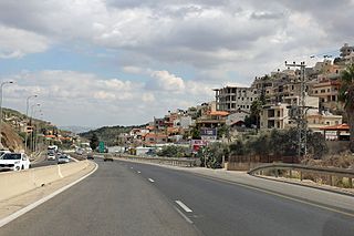
Highway 70 is a highway, 44 km in length, running through the Western Galilee region in the Northern District of Israel. It connects the Lower Galilee to Kiryat Ata and Shlomi near Israel's border with Lebanon.

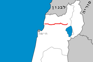
Highway 75 is a 40 km long east-west highway in northern Israel. It runs from Haifa in the west to Nazareth and Nof HaGalil in the east.
Highway 79 is an east-west highway in northern Israel. It crosses the Zevulun Valley and the western Lower Galilee. The road leads from Kiryat Bialik to Mashhad north of Nazareth. It is 27 km long.
Route 866 is a north-south regional highway in northern Israel. It begins at Hananya junction with Highway 85 in the south and ends at Meron junction with Highway 89 in the north.
The Coastal railway line is a mainline railway in Israel, which begins just south of the Lebanon-Israel border on the Mediterranean coast, near the town of Nahariya in Northern Israel and stretches almost the entire Mediterranean coast of the country, to just north of the border with the Gaza Strip in the south.

The Haifa metropolitan area is a metropolitan area including areas from both the Haifa and the Northern districts of Israel. It is located along the Israeli Mediterranean coastline. With an estimated population of almost 1 million, the Haifa metropolitan area is the third largest metropolitan area in Israel, behind Gush Dan and Greater Jerusalem.

The Railway to Karmiel is a railway linking Haifa and Karmiel in northern Israel. It opened in 2017 and consists of a double track standard gauge railway stretching for 23 km from near Acre (Akko) to Karmiel. It branches eastwards from the Coastal Railway between the Kiryat Motzkin Railway Station and the Acre Railway Station and includes a 5 km long tunnel in the mountainous region near the eastern end of the line. Most of the route is in the vicinity of Highway 85. There are two stations on the railway: Ahidud and Karmiel.

The Road of the Patriarchs or Way of the Patriarchs is an ancient north–south route traversing the land of Israel and the region of Palestine. The modern Highway 60 (Israel-Palestine) follows roughly the route of the Way of the Patriarchs. The name is used by biblical scholars because of mentions in biblical narratives that it was frequently travelled by Abraham, Isaac and Jacob.

Route 505 is a regional Israeli highway in the West Bank.
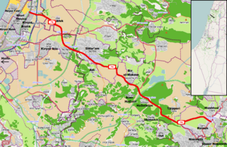
Route 436 is a regional arterial road in Israel and the West Bank between Jerusalem and Givat Ze'ev. The southern portion begins as a major urban artery in Jerusalem's predominantly Hareidi neighborhoods leading to Highway 50, to Highway 1 and to the northern neighborhood of Ramot. Further north, the road runs alongside portions of Israel's West Bank Barrier as it approaches Givat Ze'ev. It crosses Route 443 to the Tel Aviv area and Highway 45 to Atarot and ends at the Beitunia section of the security barrier. The speed limit begins at 50 km/h along its urban section becoming 70 km/h as it passes through Ramot and then becoming 90 km/h as it leaves the Jerusalem municipality northwards. The road officially ends at the Beitunya cargo transfer terminal.

The Karmiel railway station is an Israel Railways passenger terminal in Karmiel, Israel. It is located at the eastern terminus of the Railway to Karmiel. The next station to the west is Ahihud. The station was opened on 20 September 2017.

Migdal Tefen is an industrial council in the Upper Galilee, which contains only industrial plants. Within the council's area, there is a light industry and high-tech industry zone, an industrial park, the Tefen Open Museum, a rehabilitation center called Gesher, and also several restaurants. The jurisdiction area of the council extends over 2,700 dunams. It is located about 6 kilometers from Ma'alot-Tarshiha and about 17 kilometers from Karmiel, between the moshav Lapidot to the south and the community settlement Kfar Vradim to the north, and Druze villages that are located to its west and east. The head of the council, as of July 2023, is Faiz Hana.

Route 784 is a regional highway in Northern Israel, which serves as a main transportation artery for the residents of the Misgav Regional Council and connects the Jezreel Valley with the Galilee settlements by the shortest route. The road starts at the Yiftahel interchange in the south and ends at the West Karmiel interchange in the north. From the Misgav junction to the Yuvalim junction, the road overlaps with Route 805. The length of the road is 26 km (16 mi).