The Battle of Loos took place from 25 September to 8 October 1915 in France on the Western Front, during the First World War. It was the biggest British attack of 1915, the first time that the British used poison gas and the first mass engagement of New Army units. The French and British tried to break through the German defences in Artois in the north and Champagne at the south end of the Noyon Salient and restore a war of movement.

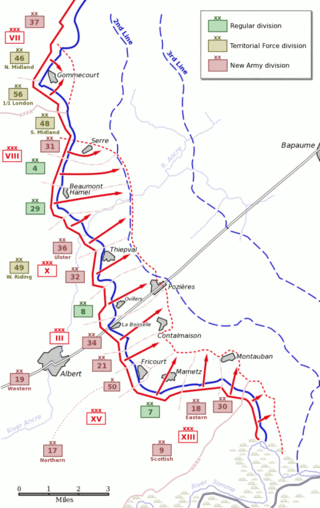
The first day on the Somme, 1 July 1916, was the beginning of the Battle of Albert (1–13 July), the name given by the British to the first two weeks of the 141 days of the Battle of the Somme in the First World War. Nine corps of the French Sixth Army and the British Fourth and Third armies attacked the German 2nd Army from Foucaucourt south of the Somme, northwards across the Somme and the Ancre to Serre and at Gommecourt, 2 mi (3.2 km) beyond, in the Third Army area. The objective of the attack was to capture the German first and second defensive positions from Serre south to the Albert–Bapaume road and the first position from the road south to Foucaucourt.

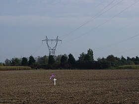
Hawthorn Ridge Redoubt was a German field fortification, west of the village of Beaumont Hamel on the Somme. The redoubt was built after the end of the Battle of Albert and as French and later British attacks on the Western Front became more formidable, the Germans added fortifications and trench positions near the original lines around Hawthorn Ridge. At 7:20 a.m. on 1 July 1916, the British fired a huge mine beneath the Hawthorn Ridge Redoubt. Sprung ten minutes before zero hour, the mine was one of 19 mines detonated on the first day of the Battle of the Somme. Geoffrey Malins, one of two official war cameramen, filmed the detonation of the mine. The attack on the redoubt by part of the 29th Division of VIII Corps was a costly failure.
The Gas Attacks at Hulluch were two German cloud gas attacks on British troops during World War I, from 27 to 29 April 1916, near the village of Hulluch, 1 mi (1.6 km) north of Loos in northern France. The gas attacks were part of an engagement between divisions of the II Royal Bavarian Corps and divisions of the British I Corps.

The Actions of the Hohenzollern Redoubt took place on the Western Front in World War I from 13 to 19 October 1915, at the Hohenzollern Redoubt near Auchy-les-Mines in France. In the aftermath of the Battle of Loos, the 9th (Scottish) Division captured the strongpoint and then lost it to a German counter-attack. The British attack on 13 October failed and resulted in 3,643 casualties, mostly in the first few minutes. In the History of the Great War, James Edmonds wrote that "The fighting [from 13 to 14 October] had not improved the general situation in any way and had brought nothing but useless slaughter of infantry".
The Capture of Mametz took place on 1 July 1916, when the British Fourth Army attacked the German 2nd Army on the Western Front, during the first day of the Battle of the Somme. Mametz is a village on the D 64 road, about 20 mi (32 km) north-east of Amiens and 4 mi (6.4 km) east of Albert. Fricourt lies to the west, Contalmaison is to the north, Montauban to the north-east and Carnoy and Maricourt are to the south-east. Mametz Wood is 1,000 yd (910 m) to the north-west and before 1914, the village was the fifth largest in the area, with about 120 houses and had a station on the line from Albert to Péronne. During the Battle of Albert the II Bavarian Corps attacked westwards north of the Somme but was fought to a standstill east of Mametz. Reinforced by the XIV Reserve Corps the Germans on the north side of the Somme attacked again and took Mametz on 29 September. After a mutually costly battle for Fricourt, where the French were eventually forced out, the front line stabilised and both sides began to improvise defences. In mid-December a French local attack in the Mametz area was a costly failure.
The Capture of La Boisselle was a tactical incident during the Battle of Albert, the name given by the British to the first two weeks of the Battle of the Somme. The village of La Boisselle forms part of the small commune of Ovillers-la-Boisselle about 22 mi (35 km) north-east of Amiens in the Somme department in Picardie in northern France. To the north-east of La Boisselle lies Ovillers; by 1916, the village was called Ovillers by the British Expeditionary Force (BEF) to avoid confusion with La Boisselle, south of the road.

The Loss of the Kink Salient occurred during a local attack on 11 May 1916, by the 3rd Bavarian Division on the positions of the 15th (Scottish) Division. The attack took place at the west end of the Hohenzollern Redoubt near Loos, on the Western Front during the First World War. An unprecedented bombardment demolished the British front line, then specially trained German assault units rushed the survivors and captured the British front line and the second line of defence; British tunnellers were trapped in their galleries and taken prisoner.

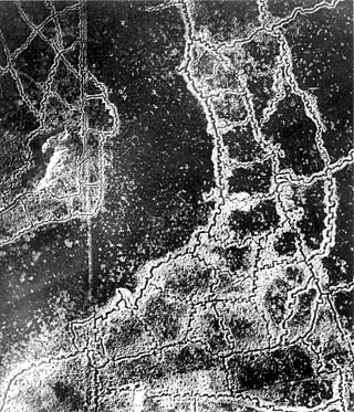
The Hohenzollern Redoubt action, 2–18 March 1916 was fought on the Western Front during the First World War. The Hohenzollern Redoubt was a German defensive position north of Loos-en-Gohelle (Loos), a mining town north-west of Lens in France. The Redoubt was fought over by the British and German armies from the Battle of Loos to the beginning of the Battle of the Somme on 1 July 1916. Over the winter of 1915–1916, the 170th Tunnelling Company RE dug several galleries under the German lines in the area of the redoubt, which had changed hands several times since September 1915. In March 1916, the west side was held by the British and the east side was occupied by the Germans, with the front near a new German trench known as The Chord. No man's land had become a crater field and the Germans had an unobstructed view of the British positions from the Fosse 8 slag heap. The British front line was held by outposts to reduce the number of troops vulnerable to mine explosions and the strain of knowing that the ground could erupt at any moment.
The Staffordshire Brigade was a volunteer infantry brigade formation of the British Army from 1888 to 1936. It saw active service on the Western Front in World War I, including the attacks on the Hohenzollern Redoubt and the Gommecourt Salient, and the assault crossing of the St Quentin Canal, 'a most remarkable feat of arms'.

In World War I, the area around Hooge on Bellewaerde Ridge, about 2.5 mi (4 km) east of Ypres in Flanders in Belgium, was one of the easternmost sectors of the Ypres Salient and was the site of much fighting between German and Allied forces.
The 170th Tunnelling Company was one of the tunnelling companies of the Royal Engineers created by the British Army during World War I. The tunnelling units were occupied in offensive and defensive mining involving the placing and maintaining of mines under enemy lines, as well as other underground work such as the construction of deep dugouts for troop accommodation, the digging of subways, saps, cable trenches and underground chambers for signals and medical services.
The 180th Tunnelling Company was one of the tunnelling companies of the Royal Engineers created by the British Army during World War I. The tunnelling units were occupied in offensive and defensive mining involving the placing and maintaining of mines under enemy lines, as well as other underground work such as the construction of deep dugouts for troop accommodation, the digging of subways, saps, cable trenches and underground chambers for signals and medical services.
The 252nd Tunnelling Company was one of the tunnelling companies of the Royal Engineers created by the British Army during World War I. The tunnelling units were occupied in offensive and defensive mining involving the placing and maintaining of mines under enemy lines, as well as other underground work such as the construction of deep dugouts for troop accommodation, the digging of subways, saps, cable trenches and underground chambers for signals and medical services. 252nd Tunnelling Company is particularly known for creating the Hawthorn Ridge mine during the Battle of the Somme 1916, which formed part of a series of mines that were placed beneath the German lines.
On the morning of 1 July 1916, the first day of the Battle of the Somme during World War I, underground explosive charges planted by British tunnelling units were detonated beneath the German front lines. The joint explosion of these mines ranks among the largest artificial non-nuclear explosions.

In World War I, the small commune of Ovillers-la-Boisselle, located some 22 miles (35 km) north-east of Amiens in the Somme department in Hauts-de-France in northern France, was the site of intense and sustained fighting between German and Allied forces. Between 1914 and 1916, the Western Front ran through the commune, and the villages were completely destroyed. After the Armistice of 11 November 1918, the former inhabitants returned and gradually rebuilt most of the infrastructure as it had been before the war.
The Y Sap mine was an underground explosive charge, secretly planted by the British during the First World War and ready for 1 July 1916, the first day on the Somme. The mine was dug by the Tunnelling Companies of the Royal Engineers under a German machine-gun nest known as Blinddarm (appendix) in the front line, on the north side of the village of La Boisselle in the Somme département. The mine was named after Y Sap, the British trench from which the gallery was driven. It was one of 19 mines on the British sector to be blown at the start of the battle.
The Actions of St Eloi Craters from 27 March to 16 April 1916, were local operations in the Ypres Salient of Flanders, during the First World War by the German 4th Army and the British Second Army. Sint-Elooi is a village about 5 km (3.1 mi) south of Ypres in Belgium. The British dug six galleries under no man's land, placed large explosive charges under the German defences and blew them at 4:15 a.m. on 27 March. The 27th Division captured all but craters 4 and 5. The 46th Reserve Division counter-attacked but the British captured craters 4 and 5 on 30 March. The Canadian Corps took over, despite the disadvantage of relieving troops in action.

The German attack on Vimy Ridge was a local attack on the Western Front on 21 May 1916, during the First World War. The Germans intended to prevent mines being blown under German positions by capturing the British front line and mine gallery entrances. After the Third Battle of Artois the French Tenth Army had held positions on the western slope of Vimy Ridge and the German 6th Army occupied positions on the steeper eastern slope. During the Battle of Verdun, the Tenth Army was withdrawn and the British First Army and Third Army, on either flank, took over the French positions.

The 5th Battalion, Lincolnshire Regiment, was a volunteer unit of Britain's Territorial Army from 1900 until 1967, serving as infantry on the Western Front during the First World War and as an air defence unit during and after the Second World War.