Holmview, Queensland

Last updated

Holmview
Logan City,  Queensland
Lima Park Holmview.jpg
Lima Park and bikeway, 2014
Australia Queensland location map.svg
Red pog.svg
Holmview
Coordinates 27°42′52″S153°10′16″E / 27.7144°S 153.1711°E / -27.7144; 153.1711 Coordinates: 27°42′52″S153°10′16″E / 27.7144°S 153.1711°E / -27.7144; 153.1711
Population2,358 (2016 census) [1]
 • Density590/km2 (1,527/sq mi)
Postcode(s) 4207
Area4.0 km2 (1.5 sq mi)
Time zone AEST (UTC+10:00)
Location
LGA(s) Logan City
State electorate(s) Macalister
Federal Division(s) Forde
Suburbs around Holmview:
Edens Landing Loganholme Beenleigh
Waterford Holmview Beenleigh
Bahrs Scrub Bahrs Scrub Beenleigh

Holmview is a residential suburb in the City of Logan, Queensland, Australia. [2] In the 2016 census, Holmview had a population of 2,358 people. [1]

Contents

Geography

It is located south-west of Brisbane, the state capital. Much of the suburb is undeveloped bush. Part of the suburb's northern border is marked by the Logan River. The Beenleigh railway line passes through this northern section. The Logan River Road, a major arterial, crosses Holmview from east to west.

History

On 1 May 1975 Holmview was designed a locality by Queensland Place Names Board. It was designated as a suburb on 7 February 2003. [2] However, the name has a longer history with Holmview railway station being mentioned in railway timetables in 1886, [3] the railway line to Beenleigh having opened on 27 July 1885. [4] Despite its name, the railway station is now within the locality of Beenleigh. [5] There is an 1889 electoral roll listing for William Mann, a leaseholder at "Holmview, Beenleigh". [6] [7]

In the 2011 census, Holmview recorded a population of 1,395 people. [8]

In the 2016 census, Holmview had a population of 2,358 people. [1]

Education

There are no schools in Holmview. The nearest primary school is Edens Landing State School in neighbouring Edens Landing. The nearest secondary schools are Windaroo Valley State High School in neighbouring Bahrs Scrub, Loganlea State High School in Loganlea and Beenleigh State High School in Beenleigh. [9]

Demographics

In the 2011 census, Holmview recorded a population of 1,395 people, 50.2% female and 49.8% male. [8] The median age of the Holmview population was 27 years, 10 years below the national median of 37. 73.2% of people living in Holmview were born in Australia. The other top responses for country of birth were New Zealand 9.2%, England 3.8%, South Africa 0.9%, Scotland 0.4%, Canada 0.4%. 87.8% of people spoke only English at home; the next most common languages were 0.9% Maori (New Zealand), 0.6% French, 0.6% Romanian, 0.4% Afrikaans, 0.4% Other Australian Indigenous Languages.

Related Research Articles

Beenleigh, Queensland Suburb of City of Logan, Queensland, Australia

Beenleigh is a town and suburb in the City of Logan, Queensland, Australia. In the 2016 census, Beenleigh had a population of 8,252 people.

Beenleigh railway line

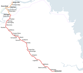
The Beenleigh railway line is a suburban railway line extending 40.1 km (24.9 mi) east-southeast from Brisbane Central railway station, the state capital of Queensland, Australia. It is part of the Queensland Rail City network.

Loganlea railway station

Loganlea railway station is located on the Beenleigh line in Queensland, Australia. It serves the suburb of Loganlea and Meadowbrook in City of Logan. The station opened in 1885 at the same time as the line. On 21 April 1992, a second platform opened as part of the duplication of the line. It is within a short distance of the Logan Hospital, TAFE college, Griffith University Logan campus, Loganlea State High School and Woolworths supermarket.

Holmview railway station

Holmview railway station is located on the Beenleigh line in Queensland, Australia. It is one of two stations serving the Logan suburb of Beenleigh, the other being Beenleigh station.

Sunnybank Hills, Queensland Suburb of Brisbane, Queensland, Australia

Sunnybank Hills is an outer southern suburb in the City of Brisbane, Queensland, Australia. In the 2016 census, Sunnybank Hills had a population of 18,085 people.

Fairfield, Queensland Suburb of Brisbane, Queensland, Australia

Fairfield is a suburb of the City of Brisbane, Queensland, Australia. In the 2016 census, Fairfield had a population of 2,980 people.

Kuraby, Queensland Suburb of Brisbane, Queensland, Australia

Kuraby is an outer southern suburb in the City of Brisbane, Queensland, Australia. In the 2016 census, Kuraby had a population of 8,108 people.

Woodridge, Queensland Suburb of Logan City, Queensland, Australia

Woodridge is a town and suburb in the City of Logan, Queensland, Australia. In the 2016 census, the suburb of Woodridge had a population of 12,579 people.

Loganlea, Queensland Suburb of Logan City, Queensland, Australia

Loganlea is a suburb in the City of Logan, Queensland, Australia. In the 2016 census, Loganlea had a population of 7,321 people.

Meadowbrook, Queensland Suburb of Logan City, Queensland, Australia

Meadowbrook is a mixed-use suburb in the City of Logan, Queensland, Australia. In the 2016 census, Meadowbrook had a population of 3,113 people.

Underwood, Queensland Suburb of Logan City, Queensland, Australia

Underwood is a suburb in the City of Logan, Queensland, Australia. In the 2016 census, Underwood had a population of 6,341 people.

Oxenford, Queensland Suburb of Gold Coast, Queensland, Australia

Oxenford is a suburb in the City of Gold Coast, Queensland, Australia. In the 2016 census, Oxenford had a population of 11,842 people.

Runcorn, Queensland Suburb of Brisbane, Queensland, Australia

Runcorn is an outer southern suburb in the City of Brisbane, Queensland, Australia. In the 2016 census, Runcorn had a population of 14,592 people.

Kenmore Hills, Queensland Suburb of Brisbane, Queensland, Australia

Kenmore Hills is a suburb in the City of Brisbane, Queensland, Australia. In the 2016 census, Kenmore Hills had a population of 2,402 people.

Yeerongpilly, Queensland Suburb of Brisbane, Queensland, Australia

Yeerongpilly is a southern suburb in the City of Brisbane, Queensland, Australia. In the 2016 census, Yeerongpilly had a population of 1,934 people.

Ransome, Queensland Suburb of Brisbane City Council, Queensland, Australia

Ransome is an outer coastal suburb in the City of Brisbane, Queensland, Australia. In the 2016 census, Ransome had a population of 405 people.

Richlands, Queensland Suburb of Brisbane, Queensland, Australia

Richlands is an outer south-western suburb in the City of Brisbane, Queensland, Australia. In the 2016 census, Richlands had a population of 3,598 people.

Electoral district of Waterford

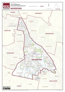
Waterford is an electoral district of the Legislative Assembly in the Australian state of Queensland.

Edens Landing, Queensland Suburb of Logan City, Queensland, Australia

Edens Landing is a suburb in the City of Logan, Queensland, Australia. In the 2016 census, Edens Landing had a population of 5094 people.

Alberton, Queensland Suburb of Gold Coast, Queensland, Australia

Alberton is a rural locality in the City of Gold Coast, Queensland, Australia. In the 2016 census, Alberton had a population of 590 people.

References

  1. 1 2 3 Australian Bureau of Statistics (27 June 2017). "Holmview (SSC)". 2016 Census QuickStats. Retrieved 20 October 2018. OOjs UI icon edit-ltr-progressive.svg
  2. 1 2 "Holmview - suburb in City of Logan (entry 48113)". Queensland Place Names. Queensland Government . Retrieved 26 January 2020.
  3. "Railway Time Tables". The Brisbane Courier . Queensland, Australia. 7 January 1886. p. 2. Retrieved 28 March 2020 via Trove.
  4. Kerr, John (1990). Triumph of narrow gauge : a history of Queensland Railways. Boolarong Publications. p. 224. ISBN   978-0-86439-102-5.
  5. "Beenleigh" (Map). Queensland Government. 1947. Retrieved 28 March 2020.
  6. Qld Electoral rolls 1860-79, 1884, 1889. Toowoomba & Darling Downs Family History Society.
  7. "Advertising". Logan Witness . Queensland, Australia. 10 July 1886. p. 2. Retrieved 28 March 2020 via Trove.
  8. 1 2 Australian Bureau of Statistics (31 October 2012). "Holmview (State Suburb)". 2011 Census QuickStats. Retrieved 7 July 2012. OOjs UI icon edit-ltr-progressive.svg
  9. "Queensland Globe". State of Queensland . Retrieved 28 March 2020.