
Horseshoe Falls is the largest of the three waterfalls that collectively form Niagara Falls on the Niagara River along the Canada–United States border. Approximately 90% of the Niagara River, after diversions for hydropower generation, flows over Horseshoe Falls. The remaining 10% flows over American Falls and Bridal Veil Falls. It is located between Terrapin Point on Goat Island in the US state of New York, and Table Rock in the Canadian province of Ontario. These falls are also referred to as the Canadian Falls.

Wells is a town in Hamilton County, New York, United States. The population was 674 at the 2010 census. The town is named after Joshua Wells, a land agent, who built the first mills in the area. It is in the Adirondack Park and on the eastern border of the county. It is northwest of Schenectady.

Piercefield is a town in St. Lawrence County, New York, United States. The population was 310 at the 2010 census.
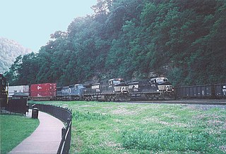
Logan Township is a township in Blair County, Pennsylvania, United States. It is part of the Altoona, PA Metropolitan Statistical Area. It is the most populous township in Blair County, with a population of 12,413 at the 2020 census. Logan Township is home to Horseshoe Curve, a National Historic Landmark.

The horseshoe is an open-faced sandwich originating in Springfield, Illinois, United States. It consists of thick-sliced toasted bread, a hamburger patty or other choice of meat, French fries, and cheese sauce.

The Chemehuevi Mountains are a mountain range that are found at the southeast border of San Bernardino County in southeastern California and are adjacent the Colorado River. Located south of Needles, California and northwest of the Whipple Mountains, the mountains are oriented in a north–south direction, and stretch for approximately 15 miles (24 km) in length.

Mount Langley is a mountain located on the crest of the Sierra Nevada, on the boundary between Inyo and Tulare counties in eastern California, in the United States. To the east is the Owens Valley, and to the west is the Kern River Valley. It is the ninth-highest peak in the state and the seventh-highest in the Sierra. Mount Whitney, the highest peak in the contiguous United States, lies 4.8 miles (7.7 km) to the northwest. Mount Langley also has the distinction of being the southernmost fourteener in the United States.

The Niagara Frontier refers to the stretch of land in the United States that is south of Lake Ontario and north of Lake Erie, and extends westward to Cleveland, Ohio. The term dates to the War of 1812, when the northern border was in contention between the United States and British forces in Canada. It refers only to the land east of the Niagara River and north of Lake Erie within the United States. The western side of the Niagara River, on the Canada/Ontario side, is the Niagara Peninsula; it is considered part of the Golden Horseshoe.

Cushetunk Mountain is a ring shaped mountain in the U.S. state of New Jersey, located in Readington and Clinton Township in Hunterdon County. The Lenape Native Americans called the mountain "Cushetunk" meaning "place of hogs" after the wild hogs found there. In the 1960s, the valley at the heart of the mountain was dammed and filled with water to create Round Valley Reservoir. Today, the mountain and its accompanying lake act as a vital water supply to Central New Jersey, while at the same time providing numerous recreational opportunities to the region.
Chiricahua Peak is a 9,773 feet (2,979 m) peak located in the Chiricahua Mountains of southeastern Arizona, located about 35 miles (56 km) north of the United States–Mexico border. It is the highest summit in the Chiricahua Mountains and the highest point in Cochise County.

The Marble Mountain Wilderness is a 241,744-acre (978.30 km2) wilderness area located 60 miles (97 km) southwest of Yreka, California, in the United States. It is managed by the United States Forest Service and is within the Klamath National Forest in Siskiyou County. The land was first set aside in April 1931 as the Marble Mountain Primitive Area, which comprised 234,957 acres (950.84 km2). It was one of four areas to gain primitive status under the Forest Service's L-20 regulations that year. In 1964, it became a federally designated wilderness area when the U.S. Congress passed the Wilderness Act.
Mummy Mountain is a mountain situated in Paradise Valley, Arizona, United States. The slopes of the mountain incorporate primarily suburban residential development while the upper summit areas are conservation sites. Camelback Inn has been located on the southern slope since 1936. As the only part of the Phoenix Mountains not held within the Phoenix Mountain Preserve, portions of Mummy Mountain are protected by the Mummy Mountain Preserve Trust and the town of Paradise Valley.

Buckner Mountain is a tall peak in the North Cascades of Washington state and in the Stephen Mather Wilderness of North Cascades National Park. At 9,114 feet (2,778 m) in elevation it is the highest in Skagit County and one of about ten of Washington's non-volcanic peaks above 9,000 feet high. It is ranked as the 14th highest peak in the state, and the third highest peak in North Cascades National Park.

Horseshoe Casino Hammond is a casino located in Hammond, Indiana. The 400,000-square-foot (37,000 m2) property containing gaming, entertainment, restaurants, bars, and lounges.
The Watchung Outliers include six areas of isolated low hills and rock outcrops of volcanic and sedimentary origin in the U.S. states of New York, New Jersey, and Pennsylvania. These geologic outliers are primarily diminutive and detached remnants of the Triassic/Jurassic age Watchung Mountain basalt flows with intervening layers of sedimentary rock. All six of the outliers are found along the western edge of the Newark Basin, occupying small synclines adjacent to the Ramapo fault system. The outliers, from north to south, are known as: Ladentown, Union Hill, New Germantown/Oldwick, Prospect Hill, Sand Brook, and Jacksonwald.
The Horseshoe Hills are a roughly crescent-shaped range of hills north of Manhattan, Montana in Gallatin County, Montana. They lie at 6,673 feet (2,034 m) in the area between the southern Big Belt Mountains and the northern Bridger Range. The hills are bounded on the north by Sixteen Mile Creek, the first major tributary of the Missouri River. As they are in the rain shadow of the Boulder, Elkhorn, and Bull Mountains to the west, the Horseshoe Hills are notably dry, receiving 10–12 inches (250–300 mm) of precipitation annually. This is especially true on the southern and southeastern flanks, which are also in the rain shadow of the hills themselves. In the driest areas, Missouri foxtail cacti, plains prickly pear cacti, and yucca abound, as well as prairie rattlesnakes. Much of the hills are private property, but there is also some state, BLM, and National Forest land.

Horseshoe Mountain is a high mountain summit in the Mosquito Range of the Rocky Mountains of North America. The 13,905-foot (4,238 m) thirteener is located 7.1 miles (11.5 km) southeast by east of the City of Leadville, Colorado, United States, on the drainage divide separating San Isabel National Forest and Lake County from Pike National Forest and Park County.

Horseshoe Park is a flat at 8,524 feet (2,598 m) in elevation in Larimer County, Colorado. It is within the Rocky Mountain National Park, which lies between Estes Park to the east and Grand Lake, Colorado on the west. Horseshoe Park is home to bighorn sheep, elk and other wildlife, and it is a wetland sanctuary for a wide variety of birds. Recreational activities include picnicking, hiking, cross-country skiing and snowshoeing. Roaring River, Lawn Lake and Crystal Lake are located here.

Hell for Sure Lake is an Alpine lake located in the John Muir Wilderness, which is part of the Sierra Nevada mountain range. The lake is at an elevation of 10,768 feet (3,282 m), has a few small rocky islands and is between Red Mountain to the north and Mount Hutton to the south. The Hell for Sure trail and Hell for Sure Pass both are named after this lake with the region being known for its rough terrain. The rocks the surround Hell for Sure Lake and its nearby mountains are estimated to be over 100 million years old.
Disappointment Lake is an Alpine lake located in the John Muir Wilderness, which is part of the Sierra Nevada mountain range. The lake is found by following the Hell for Sure Trail which continues up to Hell for Sure Lake and Hell for Sure Pass. Mount Hutton can be found approximately 1.35 mi (2.17 km) to the south east and Red Mountain can be found approximately 1.13 mi (1.82 km) to the northeast.

